I. THE ROLE OF THE DNIEPER RIVER IN THE EARLY HISTORY OF EASTERN EUROPE
A. “Put’ iz Variag v Greki” 19
B. Theories based on the Annales Bertiniani 23
C. The testimony of Muslim sources 27
D. Byzantine sources and the Russian Primary Chronicle 31
The understanding of developments in the history of Kievan Rus has been obscured by the perseverance of opinions based on some assumptions with little or no documentation. Such is the case with the belief that the River Dnieper played a crucial role in the growth of the political and economic strength of Kievan Rus. [1] In reality, the Dnieper performed at times a positive, and at times a negative, role, depending on various, constantly changing, factors. Although it may be true that the Dnieper provided economic possibilities for the growth of a state, these possibilities were never fully utilized in the Middle Ages because of insurmountable difficulties created by the very nature of the river, as well as by the political conditions along its banks.
Another opinion which persists without much recourse to sources is that there existed a waterway connecting the Scandinavian North with Byzantium along the rivers of Eastern Europe, and that this route was essential for the economic life of the Kievan State. A most frequently quoted phrase from the Primary Chronicle is the reference to a route “from the land of the Varangians to Greece” (“put’ iz Variag v Greki”). Emphasis on opinions rather than on facts caused the phrase to be translated into English as “a trade route [which] connected the Varangians with the Greeks”. [2] This mistranslated phrase is often the sole argument in support of the notion that there was a large-scale trade exchange between Scandinavia and Byzantium and that the whole of Kievan Rus flourished on that trade.
1. Among others:
V. O. Kliuchevskii, Sochineniia, Vol. I (Moscow, 1956), pp. 123-24, 144-46;
Lubor Niederle, Rukovet slovanskych starožitnosti (Prague, 1953), pp. 132, 382, 388;
B. H. Sumner, A Short History of Russia (New York, 1943), pp. 16, 27;
R. J. Kerner, The Urge to the Sea: The Course of Russian History (Berkeley-Los Angeles, 1946), pp. 14, 19;
Frederick Kaplan, “The Decline of the Khazars and the Rise of the Varangians”, The American Slavic and East European Review, XIII (1954), pp. 1, 3;
Henryk Paszkiewicz, The Origin of Russia (London, 1954), p. 139.
2. The Russian Primary Chronicle, Laurentian Text, translated and edited by Samuel Hazzard Cross and Olger P. Sherbowitz-Wetzor (Cambridge, Mass., 1953), p. 53 (hereinafter cited as The Russian Primary Chronicle).
![]()
19
A. "PUT' IZ VARIAG V GREKI”
Even today lakes and rivers offer the cheapest means of inland transportation. The role of the waterways in shaping the economic and political life of people was much more evident during the Middle Ages, when wheeled transport was difficult and time less valued than it is today. Medieval cities of economic significance grew along navigable rivers, at the mouths of such rivers, or at places where rivers and other trade routes converged, and where the adjacent region provided a sizeable market.
Eastern Europe is especially well endowed with rivers connecting the core of the continent with all of the surrounding seas. There are no big mountains to hinder overland transportation of goods between two navigable rivers. The system of portages, developed and maintained during the Middle Ages for the purpose of auxiliary traffic, made all of Russia accessible by boat. (Moscow is today a port serving five seas by means of a network of rivers and canals.)
The political unity of Eastern Europe is, in part, the result of the economic interdependence of her regions based on her rivers. The expansion of Russia across the Ural Mountains into Asia, to the shores of the Pacific, was accomplished mainly by boat along the rivers, which are connected by relatively short and flat portages. [3] In this case, economic expansion was followed closely by political integration.
In the history of Kievan Rus, the most important river was obviously the Dnieper. Kiev is located in the center of a large geographic region drained by that river and its tributaries. The rivers of the Dnieper Basin provide conditions for an economically independent region, the prosperity of which depends on the political consolidation of that area and on peaceful conditions along the borders for the pursuit of trade with neighbors.
The opinion that the Dnieper was used primarily as an economically important transit route connecting the Scandinavians with the Greeks is based on the following description of East European waterways given in the Primary Chronicle:
When the Polanians lived by themselves among these hills, there was a route from the Varangians to the Greeks. And starting from the Greeks [this route proceeds] along the Dnieper. At the upper part of the Dnieper [there is] a portage to the river Lovat, and along the Lovat one may enter the great lake Ilmen. From this lake flows out the river Volkhov and flows into the great lake Nevo. And the mouth of that lake opens into the Varangian Sea. Over this sea one may go to Rome and from Rome, over the same sea, one may arrive at Constantinople. And from Constantinople it is possible to enter the
3. Cf. B. H. Sumner, op. cit., p. 22; D. M. Lebedev, Ocherki po istorii geografii v Rossii XV i XVI vekov (Moscow, 1956), pp. 27-116, maps 3-12, especially map no. 4. See also article and map “Velikie geograficheskie otkrytiia” in Sovetskaia istoricheskaia entsiklopediia, Vol. 3 (1963), cols. 135-39.
![]()
20
Black Sea. Into this [sea] flows the Dnieper River. The Dnieper itself flows out from the Okov Forest. And from the same forest flows the River Dvina and goes northward and enters into the Varangian Sea. From the same forest flows the Volga eastward and flows into the sea of Khvalis through seventy mouths. So that from Rus it is possible to go along the Volga to the Bulgars and to the Khvalisians and [going] eastward one may arrive to the region I which is the share of Shem. And along the Dvina lone may go] to the Varangians, from the Varangians to Rome, then from Rome to the tribe of Ham and the Dnieper flows into the Black Sea through a mouth. This sea is named [also] the sea of the Rus. Beside it was teaching, as it is said, St. Andrew, brother of Peter. [4]
At the first reading of this passage one encounters some apparent contradictions. First, traveling along the Volga, passing the Bulgars, and before reaching the sea, one should cross the land of the Khazars and not the land of the Khvalisians. Second, the actual description of “the route from the Varangians to the Greeks” starts from the south and not from the north, as implied in the opening sentence of that fragment. This route is then extended to lead around Europe to Rome and back to Greece, forming a full circle. Third, the shortest route from the Varangians to the Greeks leads not along the Volkhov and Lovat, but along the Western Dvina. Fourth, the description mentions only one portage between the Dnieper and Lovat, while in reality there are two. Finally, a serious problem is posed by the chronological inconsistency: according to the Primary Chronicle, the Varangians first appeared in Kiev only around the middle of the ninth century, [5] but the description of the waterway is interpreted usually as if the route had been used by them much earlier, “when the Polanians lived by themselves”.
In order to analyze the description and understand it as it was understood by the Chronicler, we have to approach it, not as an isolated episode, but against the background given by the Chronicle itself.
The fragment of the Chronicle directly following the description of the waterways is the legend of St. Andrew. St. Andrew, according to the Chronicler, desired to return from Sinope in Asia Minor to Rome. The first part of his journey was to the Greek city of Chersonesus in the Crimea, then up the Dnieper past the hills where later Kiev was founded and up to the Slovenes “where Novgorod is now situated”. From here the saint went to the Varangians and later to Rome, obviously around Europe. After a sojourn in Rome he departed again, this time directly to Sinope.
After reading this fragment, one may immediately observe that the
4. Cf. Povest’ vremennykh let, editing of text and comments by D. S. Likhachev, modern Russian translation by D. S. Likhachev and B. A. Romanov, edited by V. P. Adrianova-Perets, vol. I (Moscow-Leningrad, 1950), pp. 11-12 (hereinafter cited as Likhachev, Povest vremennykh let).
5. Likhachev, Povest vremennykh let, p. 20.
![]()
21
details of St. Andrew’s itinerary are similar to, although not identical with, the description of the route “from the Varangians to the Greeks”. A closer analysis reveals, however, that the similarity does not result from repetitiveness but that the two descriptions are complementary to each other. The first is a description of a possible route, the second of an actual journey. A close genetic relation between the two descriptions can immediately be deduced when the relevant fragments are arranged in parallel columns:
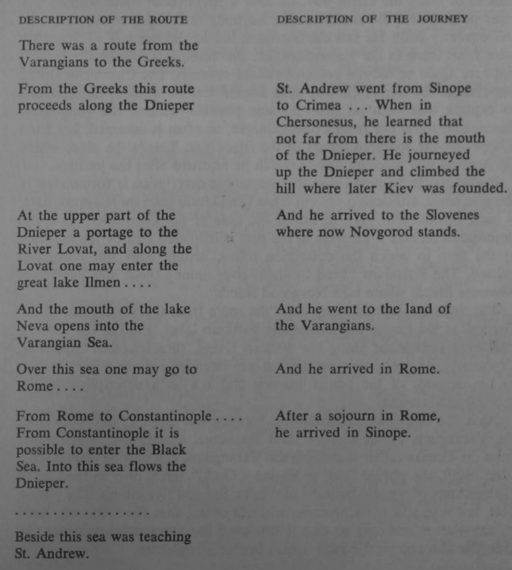
It appears obvious that the Chronicler regarded the two fragments as a unit: The last sentence of the first column, “Beside this sea was teaching St. Andrew” is not the end of a separate paragraph, but a transition to the description of the actual journey undertaken by the Saint. The modern
![]()
22
editions of the text and translations break up the original text into convenient. but arbitrary, paragraphs reflecting the logic of the editors but not that of the Chronicler.
The joint treatment of the two descriptions allows us to draw several obvious conclusions. First of all, the description of the route is a geographic introduction to the description of the journey. The Chronicler knew the legend about St. Andrew “as it is said”, but some of the elements appeared to him to be unusual: The saint wanted to go to Rome, but instead of using the direct way, he took a roundabout route without any clear purpose. He did not encounter anybody at the spot where Kiev was subsequently built. He saw the Slovenes, but he did not talk to them. He went from there to the Varangians, i.e. the ‘foreigners around the Baltic’, but here again he did not preach or make converts. The Chronicler would not change the legend (it was done later), [6] but he wanted, nevertheless, to explain that such an itinerary was possible. Hence, the geographic description starts not from Constantinople, as often is assumed, but from Sinope, on the southern shores of the Black Sea. This is the place where St. Andrew was teaching and to which he returned after the journey.
It also has to be noted that the geographic description is formulated in the past tense, although a present tense would have been more appropriate, if such a route had been in use at the time of the Chronicler. That the description reflects a situation in the past is indicated also by the fact that at the time to which the description refers, neither Kiev nor Novgorod existed. The Polanians “lived by themselves among these hills” and “the Slovenes (lived) where now Novgorod stands”.
The apparent inconsistency that “the route from the Varangians to the Greeks” is the longer way across the northern lakes, and not the shortest and most convenient along the western Dvina, thus becomes explained. Obviously, the geographic description was intended only as a introduction to the account of the actual journey and not as a description of the shortest trade route.
Also, the disturbing contradiction between the caption “the route from the Varangians to the Greeks” and the actual description, which starts from the Greeks rather than from the Varangians, can now be disregarded. First of all, the phrase “put’ iz Variag v Greki” refers only to the fact of the existence of a route between the Baltic Sea and Byzantium. The phrase does not say, and the Chronicler did not mean, that the route was used by the Varangians only or that it was used for commercial purposes. So even the chronological contradiction becomes irrelevant.
6. For a bibliography on the St. Andrew legend and a short discussion of the Legend’s evolution see: Georg von Rauch, “Frühe christliche Spuren in Russland", Saeculum, MI (1956), pp. 43-45. See also A. A. Shakhmatov’s “Povest vremennykh let i ee istochniki", Trudy otdela drevne-russkoi literatury, IV (1940), pp. 29, 249-50. See also: B. A. Rybakov, Drevnaia Ruś (Moskva. 1963). p. 225 (map) and pp. 242 ff.
![]()
23
Finally, the observation should be made that the Russian terms iz Variag and v Greki do not refer to any ethnic groups but only to two geographic regions. Iz Variag means from the foreign lands around the Baltic. Ot Variag would mean from the Varangians. Similarly, v Greki means to Greece, k Grekam would mean to the Greeks. The so often misinterpreted and mistranslated caption iz Variag v Greki should actually be interpreted to read: from the foreign lands around the Baltic to Byzantium. [7]
It is now possible to conclude that the description of the waterway “iz Variag v Greki” is part of the St. Andrew legend. The geographic elements of the route do. in fact, correspond to reality, but the description cannot be used to approximate the date when such a route was discovered or frequented by the Varangians. Consequently, the phrase “a route from the Baltic to Byzantium” cannot be used as evidence for the economic significance of the Dnieper.
B. THEORIES BASED ON THE ANNALES BERTINIAN1
Another source frequently used in connection with the problem of the use of the Dnieper River is the Annales Bertiniani. [8] This chronicle, which originated in Western Europe, contains the first undisputed reference to the people named Rhos. The source is highly reliable, because it is contemporary with the events it describes and because it was composed - or at least the part important for the study of early Russian history - by Bishop Prudentius of Troyes.
According to Bishop Prudentius, who was probably an eye witness of the events:
“Envoys of the Greeks arrived, dispatched by the Emperor Theophile. ... The Emperor [Louis I] received them with honors on the 18th day of May [839] in Ingelheim.” With those envoys came “some people who said that they, that is, their people, were named Rhos”. Theophile sent Louis a letter, in which he explained the background of these Rhos people. The king of theirs [i.e., of the Rhoses], named Chaganus, dispatched them to him [i.e., to Theophile] in the cause of friendship (amicitiae causa)." [9]
Theophile appealed to Louis I to assist the Rhos envoys in their attempt to return home on a roundabout way “because the roads on which they
7. There are basic semantic differences between the forms v Greki, k Grekam, na Greki. The first form means ‘into Greece’, the second ‘to the Greeks’, and the third ‘against the Greeks’.
8. Annales Bertiniani, in Monumenta Germaniae historica. Scriptores, Vol. I (Hannover. 1826). A new edition of the Annales Bertiniani is included in the Fontes ad historiam regni Francorum aevi Karolini illustrandam, Vol. II (Darmstadt, 1958), hereinafter cited as Annales Bertiniani.
9. Annales Bertiniani, s.a. 839.
![]()
24
came to him to Constantinople lead through wild, extremely ferocious tribes”.
Bishop Prudentius also recounted that Louis made some investigations of the background of the Rhos envoys and “he found out that they belonged to, or were by origin, Sueones, (“comperit, eos gentis esse Sueonum”). He suspected that the envoys were not on a tour of friendship but rather on a spying mission, collecting intelligence both in Greece and in the Carolingian Empire. [10] Louis, using the pretext of danger along the frontiers of his own empire, detained the envoys and sent a letter to Theophile explaining his suspicion. Unless the suspicion was cleared by both of them, Louis was prepared to send the envoys back to Theophile. [11]
There is unanimous agreement among the scholars of early Russian history that the Rhos envoys were the same people known to the Greeks as ‘Ros’ and to the Arabs as ‘Rus’, and that all these names refer to the ancestors of the Russians. This consensus of scholarly opinion ends when we come to the problems of their ethnic origin and the more exact location of their abodes in the earlier part of the ninth century. The problem of the ethnic character of the Rhos envoys should not concern us here. More important for the present study are the questions from where the Rhos envoys came to Constantinople, and whether they used the Dnieper waterway.
As we learned from Bishop Prudentius, the return of the Rhos envoys to their homes by a direct route starting in Constantinople was hindered by some “wild and extremely ferocious tribes”. The name of these tribes has not been preserved in the Annales Bertiniani, but we may assume that they were nomadic groups somewhere in the steppe zone north of the Black Sea menacing the Byzantine possessions. The Rhos people must therefore have lived somewhere north, not only of the Greeks, but also north of the dangerous steppe zone.
In this general area Ibn Khurdādhbeh, a well-informed Arabian geographer of the ninth century, reported some Rus merchants who were interested in fur trade with the Arabic East. The information of Ibn Khurdādhbeh refers to a period prior to 847 (the date when his description was composed). According to his information, the Rus are “a tribe from among the aṣ-Ṣaqāliba [people]. They bring furs of beavers and of black foxes and swords from the most distant parts of the Ṣaqlabiya [land] to the sea of Rum, [where] the ruler of ar-Rum levies tithes on them. If they want, they travel on the Itil, the river of the aṣ-Ṣaqāliba and pass through Khamlīj, town of the Khazars....” [12]
The river aṣ-Ṣaqāliba is definitely the Volga River, because on its banks
10. Ibid., “... exploratores potius regni illius nostrique quam amicitiae petitores...”
11. Ibid.
12. Text in Tadeusz Lewicki’s Źródła arabskie do dziejów Słowiańszczyzny, Vol. 1 < (Wrocław-Warsaw, 1956), pp. 76-77 (hereinafter cited as Lewicki, Źródła arabskie)
![]()
25
was Khamlīj, the city of the Khazars. The sea of Rum is the Mediterranean, to which a sea route led from the Baltic. For Ibn Khurdādhbeh, who lived in the Bagdad Caliphate, “the most distant part of the Ṣaqlabya [land]” must have been, therefore, an area in northwestern Europe, from where there was easy access both to the Volga River and to the Baltic. From such a region the Rus merchants could travel without much hindrance to the Khazars. This conclusion is in agreement with the Primary Chronicle, where the information on the Varangians in general, and on the “Varangian Ruses” in particular, connects them first with the northwest, the region around Lake Ilmen, before their appearance in Kiev in the fifties of the ninth century. [13]
There still remains the problem of the route their envoys might have used for the journey from the Lake Ilmen region to Constantinople. Traveling from the northwest to Constantinople, the Rhos had a choice of three routes: the roundabout sea route, the Dnieper, and the Volga/Don waterways. Of course, they could also have used any combination of waterways and roads, but since the people of Rus were expert boatmen, it is wholly unlikely that the envoys traveled by land. Neither is the sea route a possibility, because Bishop Prudentius explicitly stated that the envoys could not use for the return journey those roads by which they had come to Constantinople because they led through wild, extremely ferocious tribes. Of the two river routes, the connection along the Volga and Don would seem the more likely, since the use of the Volga route is attested to by Ibn Khurdādhbeh for times prior to 847 (the date of his compilation). As for the Dnieper there is no evidence that it was used before 860 for transport.
The problem of floating down the rivers to the Black Sea is rather a simple venture compared to the problem of going up the rivers, especially when the banks of a river are controlled by nomads. In case of disturbances in the Pontic Steppes, the Dnieper would be the river most exposed to dangers, because this river was far from Khazar, Byzantine, or Danubian-Bulgar military centers capable of, or interested in, fighting the nomads in that region. But it would be equally dangerous to use the Dniester or the river Don. Theoretically, the Volga, controlled by the Khazars, was still at the disposal of the Rus envoys. For the Greeks it would have been no problem to have sent the Rus envoys to the Crimea and thence to the eastern shores of the Black Sea, where the Khazars could have provided further assistance for the journey up the Volga.
A. A. Shakhmatov has suggested that at the time of the envoys’ attempted return home, the rivers were not considered for the journey because, according to him, the Rus people were plotting with the Greeks against the Khazars. Shakhmatov has entirely disregarded the possibility
13. Likhachev, Povest vremennykh let, p. 18.
![]()
26
of dangers posed by some nomads, although he has quoted the relevant text of the Annales Bertiniani in Latin and also in Russian translation.
There is, however, no evidence brought forward by Shakhmatov to support his suggestion, and the theory, therefore, cannot be sustained. The theory has obvious weaknesses: The Greeks could not have expected any benefits from a conflict with the Khazars, who could have easily overrun the Byzantine grain-producing possessions on the Crimea. Furthermore, there was no cause for friction between the Khazars and the Greeks of Byzantium at this time, since both nations were exposed to the dangers of the strong and militant Arabs and, in fact, shortly before the Rus envoys’ arrival, were cooperating in strengthening their defenses against new, common enemies from the steppes. [14]
B. D. Grekov was definitely of the opinion that the Dnieper was the river on which the envoys moved down to the Black Sea and on which they intended to return. Grekov’s simple argument was that the Chagan of Rus had his residence in Kiev. The aim of the mission was to enter into an alliance with the Greeks against the Pechenegs, who in Grekov’s opinion were already at this time (i.e., 839) around the banks of the Dnieper. [15] In Grekov’s theory there are weak points of argumentation and also serious chronological inconsistencies:
First of all, there is no evidence that a Khagan of Ruses resided in Kiev before the middle of the ninth century. The Oriental sources, Ibn Rūsta, the anonymous Persian author of Ḥudūd al-'Ālam and Gardīzī, in fact, used the title ‘qaghan’ for the ruler of Rus, but without definitely indicating when and where such a Khagan resided. [16] All these Oriental sources were composed during the tenth and eleventh centuries. The fragments dealing with the Rus and other peoples of Eastern Europe reflect a situation existing in the second rather than the first part of the ninth century.
Furthermore, Grekov’s identification of the nomads with the Pechenegs is a gross anachronism because the Pecheneg federation did not appear in Eastern Europe until the second half of the ninth century, probably only around the year 880. This is the date when they crossed the Volga. [17]
The whole structure of theories presented by Grekov was demolished, actually by himself, when in the same study some pages later, he quoted the Primary Chronicle that in “915 the Pechenegs came for the first time against the land of Rus”. Grekov had no reservations about the accuracy
14. For A. A. Shakhmatov’s opinion see his Drevneishia sudby ruskago plemeni (Petrograd. 1919), pp. 57-58. For the Khazar-Byzantine cooperation see below, pp. 70-71.
15. Ocherki istorii SSSR III-IX vv., edited by B. A. Grekov (Moscow, 1958), p. 75.
16. Ḥudūd al-'Ālam, ‘The Regions of the World', translated and explained by V. Minorsky (London, 1937), p. 159. The title Kagan was applied later to Vladimir the Saint, Jaroslav the Wise, and Oleg, son of Sviatoslav.
17. C. A. Macartney, The Magyars in the Ninth Century (Cambridge, 1930), p. 86.
![]()
27
of the Chronicle’s statement, but even paraphrased the sentence, repeating that the Pechenegs lived their nomadic life between the Don and the Danube at the beginning of the tenth century.
Since all these speculations do not prove that the Ruses used the Dnieper, it must be admitted that the information contained in the Annales Bertiniani gives no clue to the existence of a waterway along that river which could have been used for transportation as early as 839. Only the hypothesis may be proposed that the danger in the steppes, north of Byzantium, extended from the Danube to the Volga and that it was for this reason that the Rus envoys could not utilize any of the rivers and had to return home across the lands of Louis I.
C. THE TESTIMONY OF MUSLIM SOURCES
Another document, contemporary with the Annales Bertiniani, which must be considered in a discussion of the chronology and utilization of the East European waterways, is the “Book of Roads and Kingdoms” by Ibn Khurdādhbeh, the author already referred to in connection with the problem of the geographic location of the earliest abodes of the Ruses in Eastern Europe.
The “Book of Roads and Kingdoms” was composed, as already indicated, in 847; hence, it has exceptional value for the chronology of developments in Eastern Europe. Ibn Khurdādhbeh was especially interested in trade routes and was able to assemble a wealth of relevant information covering Europe from Spain to the Urals and the lands of the Near and Far East.
There are two fragments in Khurdādhbeh’s book that deserve closer attention. The first fragment contains a description of the waterways used by the Rus merchants and the second deals with the routes used by the Radanite Jewish merchants for their trade between Spain and the Far East. [18] Part of the first fragment has already been quoted, [19] but here the complete text of both fragments is reproduced to permit closer analysis.
"The Route of the ar-Rus Merchants"
They are a tribe from among the aṣ-Ṣaqāliba. They bring furs of beavers and of black foxes and swords from the most distant parts of the Ṣaqlabiya [land] to the sea of Rūm [where] the ruler of ar-Rūm levies tithes on them. If they want, they travel on the Itīl, the river of the aṣ-Ṣaqāliba and pass through Khamllj, the town of the Khazars, [where] the ruler of it levies tithes on them. Then they arrive at the sea of Gurjān and they land on that shore of it which they choose. The diameter of that sea is 500 farsakhs. On occasion they bring their merchandise on camels from Gurjan to Bagdad, [where]
18. Lewicki, Źródła arabskie, pp. 76-77.
19. See above, p. 24.
![]()
28
aṣ-Ṣaqāliba eunuchs serve them as interpreters. They claim to be Christians and pay (only) head tax.
"Their [i.e., the Jewish Merchants’] Land Route"
The Jewish merchant who starts out from Spain or from the land of the Franks traverses the sea in the direction of as-Sūs al-aqṣā. [From there] he proceeds to Tanger, then to Ifrīqiya, Miṣr [i.e., Egypt], Ramla, Damascus, al-Kūfa, Bagdad, al-Busra, al-Ahwāz, Fars, Kirman, Sind, India, and China. On occasion, [the Jewish merchants] take [the road] above Rūmiya [i.e., Byzantium], across the aṣ-Ṣaqāliba [land], thence to Khamllj, the town of the Khazars; thence in the direction of Balh and of Mā warā' an-nahr [i.e., Transoxania], thence to Wurtu [Ordu] Toghuzguz, thence to China. [20]
The river aṣ-Ṣaqāliba in the itineraries quoted above, as already mentioned, flows into the Caspian Sea (sea of Gurjān) [21] and can be easily identified with the Volga. This river was used by tradesmen at least since the times of the Gothic domination over the regions north of the Black Sea. The Volga was probably used already by those Suehans who, according to Jordanes, the historian of the Goths, were engaged in fur trade with Byzantium. [22] According to Jordanes, the Suehans arrived in Byzantium after having traversed lands of many peoples. J. Marquart suggested that the Suehans used the Volga, the Don, the Sea of Azov, and the Black Sea. [23] We should note here that the Suehans of Jordanes and the Sueons-Rhoses of Bishop Prudentius seem to be the same people, or of similar ethnic extraction.
The Volga-Don route to Byzantium used by Scandinavians was discontinued at the downfall of the Gothic empire, when the fur trade with Byzantium was taken over by the nomads. The Volga was not rediscovered by Scandinavians until the earliest part of the ninth century, when it was used for contacts between the regions around the Baltic and the lands of the Arabic East.
There is less agreement as to the second route used by the Rus merchants. The problem is whether the route “from the most distant parts of the Ṣaqlabiya [land] to the Sea of Rum” led along the Dnieper or around Europe to the Mediterranean. [24]
A sea route around Europe was known to Ibn Ḥauqal, another Arabic
20. For the Radanite Jewish merchants cf. Solomon Katz, The Jews in the Visigothic and Frankish Kingdoms of Spain and Gaul (Cambridge, Mass., 1937).
21. Cf. Lewicki, Źródła arahskie, pp. 20, 115; see also Ḥudūd al-'Ālam, ‘The Regions of the World', translated and explained by V. Minorsky (London, 1937), pp. 179-186.
22. Jordanes, Getica 3, 21. I
23. Joseph Marquart, Osteuropäische und ostasiatische Streifzüge (Leipzig, 1903), p. 513 (hereinafter cited as Marquart, Streifzüge). Cf. Lewicki, Źródła arabskie, pp. 135-37.
24. For the complex problem of names used for various seas cf. Encyclopaedia of Islam, s.v. “Buntus”, “Baḥr al-Khazar”, “Baḥr ar-Rūm”.
![]()
29
Geographer of the middle of the tenth century. He described a connection between “the bay beyond the land of Ṣaqlaba“ and Spain, which was used by merchants trading in beaver skins. [25] For the Arabs this “bay beyond the land of Ṣaqlaba“ was the Baltic. [26] The most convenient connection from the Baltic to Spain was, of course, the one by sea.
The same author knew that the Ruses had frequented this route. According to him the Ruses used to travel from the Khazars across Byzantine possessions to Spain, and then, further on to their homelands. [27] Travel over such a long roundabout way at the time when the Volga was already in commercial use must be explained as a necessity dictated by strictly technical requirements. It was easy for the Rus, from a base around Lake Ilmen, to float down to the Caspian, but the return up the river was difficult and sometimes dangerous.
This report of Ibn Ḥauqal describes a practice of the Ruses as observed in the tenth century, but his information adds credibility to Ibn Khurdādhbeh’s report that a connection between the Baltic and the Mediterranean leading around Europe existed already before 847.
Further evidence for the existence of a sea route frequented by the Northmen can be derived from sources describing the Viking raids against the cities of Western Europe. These raids were conducted from Scandinavia and Denmark by boats. From a chronological point of view, the information related by al-Ya'qūbī (end of the ninth century) that a people named Rus attacked Seville in H. 233 (843/4) is of importance. [28] This raid was an extension of the yearly attacks of the Northmen against the cities of France and Germany. In 844, going up the Garonne, they plundered Toulouse. In 845, they arrived in Paris and collected seven thousand pounds of peace money. [29]
The attack on Seville is especially significant because al-Mas'ūdī (c. 950), when dealing with the same or a similar attack on Andalusia, adds the explanatory note that the attack was made by the Rus people, because they were the only sea-going people using the waterways connecting the ocean with the Maeotis (i.e., the Sea of Azov). [30]
There is a dispute among scholars as to the identity of the Rus people attacking Seville in 843/4, but this problem is here of lesser importance. [31] Although al-Mas'ūdī has mentioned the Sea of Azov, the attack against Seville did not come from the Mediterranean. His information reflects only the fact that the Ruses were known all around the coastal line of Europe.
25. Opus geographicum auctore Ibn Haukal, edited by J. H. Kramers, Vol. II (Leiden, 1938), p. 392.
26. M Cf. Lewicki, Źródła arabskie, pp. 93, 98.
27. Marquart, Streifzüge, p. 474; cf. Lewicki, Źródła arabskie, p. 131.
28. Lewicki, Źródła arabskie, pp. 250-51.
29. Annales Bertiniani, s.a.
30. Lewicki, Źródła arabskie, pp. 270-71.
31. Various semantic meanings of the term ‘Rus’ will be discussed on pp. 102-108.
![]()
30
Both the Western and the Oriental sources provide sufficient background to identify the route “from the most distant part of Ṣaqlabiya [land] to the sea of Rum” with a roundabout sea route. The trade contacts between the lands of the Baltic and the Mediterranean were in the hands of the Northmen.
The second fragment quoted from Ibn Khurdādhbeh’s “Book of Roads and Kingdoms” describes an overland route connecting Spain across Europe with India and China. This overland route was an alternative for some other possible itineraries leading across the Mediterranean or North Africa. [32] All these routes were used by the Radanite Jewish merchants. [33] A trade route from Western Europe to Kiev is well attested to in medieval Hebrew sources, and it is assumed that this route formed part of a longer road leading to the Bulgars on the Volga and to the Khazars. [34] Ibn Khurdādhbeh definitely confirms that such an overland route existed as early as the first part of the ninth century. This route was continued along the Volga to the city of the Khazars, Khamlīj.
Both fragments of Ibn Khurdādhbeh analyzed here and other itineraries described by him in detail indicate his broad interest and good sources of information.
What should attract our attention is the conspicuous absence in his work of any reference to the river Dnieper. What is more, this river is unknown to any other oriental authority describing Eastern Europe in this period.
There is direct evidence that Ibn Khurdādhbeh used in his compilation also the work of al-Jarmī. This author, an educated Arab, spent some eight years in Byzantium as prisoner of war, probably in close contact with the officials of the Imperial Court. Al-Jarmī has an accurate description of the lands and peoples neighboring Byzantium. [35] Any information on the existence of a trade route along the Dnieper, especially if used by Scandinavians or Slavs for trade with Byzantium, would have been reported by al-Jarmī. Absence of such information from al-Jarmī’s own intelligence and from other sources used by Ibn Khurdādhbeh creates a strong case for the assumption that no such route was in operation at the time of al-Jarmī's release from captivity (845/6) or at the time when Ibn Khurdādhbeh compiled his survey of roads (847).
32. Various roads leading from Western Europe to the Far East are described and discussed by Lewicki in his Źródła arabskie, pp. 141-52.
33. V. Minorsky in his comments on Ḥudūd al-'Ālam, p. 429, ascribes those routes also to the Rus. This view was criticized by Lewicki, Źródła arabskie, pp. 118-19.
34. Źródła hebrajskie do dziejów Słowian i niektórych innych ludów Środkowej i Wschodniej Europy, edited by Franciszek Kupfer and Tadeusz Lewicki (Wrocław-Warsaw, 1956), pp. 66-83.
35. On Al-Jarmī and the sources used by Ibn Khurdādhbeh, cf. Lewicki, Źródła arabskie, pp. 57-63.
![]()
31
D. BYZANTINE SOURCES AND THE RUSIAN PRIMARY CHRONICLE
The earliest source on which a hypothesis concerning the utilization of the Dnieper can be based is the homilies of Patriarch Photius of Constantinople. [36] This is one of the few medieval sources of rare accuracy and authenticity. Important for our purposes is the description of an attack against Constantinople in the summer of 860. The description of the attack is part of a sermon delivered by Patriarch Photius a week or two after the enemy’s departure. In accordance with medieval Byzantine practice, the sermon was probably recorded in shorthand, [37] and hence the description is of a unique documentary value. The sermons of Photius indicate that the attack was unexpected and that the occasion was the first encounter of the Greeks with a yet unknown people. At the time of the attack and when the sermons were delivered, Photius did not yet know the name of the enemy. The impression of Photius was that the invaders came “out of the farthest north . . . they were sundered off from us by so many lands and kingdoms, by unnavigable rivers and harborless seas”. He identified the enemy as “a barbarous Scythian tribe”, an epithet reserved in Greek sources for the nomads of Eastern Europe. “That nation was obscure, insignificant, and not even known until the incursion against us.” “A nation ranked among slaves, unknown, but which has won a name from the expedition against us, insignificant, but now become famous . . . a nation dwelling somewhere far from our country, barbarous, nomadic. . . ” [38]
The identification of those who attacked Constantinople in 860 was made later by the same Photius. In an encyclical letter dated 867, he reported to the Oriental archbishops that a people named Ros had subordinated themselves to the Byzantine Empire and, instead of continuing their robberies, had become good friends of the Greeks. They changed their heathen religion for the faith of the Christians. [39] There are entries in various Byzantine chronicles which directly identify the enemy of the year 860 with the Ruses of Eastern Europe, and even state that the attack came by way of the Black Sea. [40]
If we turn now to the Primary Chronicle and read the passages about the arrival of the Varangian Ruses at Kiev, we have every reason to believe that the description of events given there reflects historical facts which preceded the attack on Constantinople:
36. There is a new translation of this source, The Homilies of Photius, Patriarch of Constantinople, English Translation. Introduction and Commentary by Cyril Mango (Cambridge, Mass., 1958).
37. Ibid., “Introduction”, p. 8.
38. Ibid., pp. 82, 88, 96, 98.
39. Migne, Patriologia Graeca, Vol. 102, col. 736-37.
40. For an evaluation of other relevant sources cf. the comments of Mango to The Homilies of Photius (see note 36).
![]()
32
Year 856. With him [i.e., with Rurik in Novgorod] there were two men not of his clan but nevertheless boyars. And they both asked permission to go to Constantinople with their kinsmen. They both [with their families] went down along the Dnieper and, when passing by, they noticed on the hill a small burgh. And (the two) inquired, saying: “To whom does this small burgh belong?”. . . Askold and Dir remained in this burgh and gathered many Varangians and began to rule over the Polanian land while Rurik was reigning in Novgorod.
Year 860. Askold and Dir went against the Greeks... [41]
This story complements the testimony of Photius and in turn, the authenticity of the Patriarch’s description enhances, in this case, the credibility of the Primary Chronicle. The Primary Chronicle is the only source describing the arrival of the Varangians in Kiev, but the information, nevertheless, should be considered reliable. There are no sources which would contradict the Kievan tradition. There should be no doubt that the two Rus leaders, Askold and Dir, arrived in Kiev only shortly before the attack on Constantinople. As the Ruses were unknown in Constantinople in 860, so were they unknow in Kiev only a few years earlier.
The combined evidence of Photius’ writings and of the Primary Chronicle allows us to draw the following conclusions: The Ruses appeared in Kiev only in 856, and they used for their exploits the Dnieper. Along the same Dnieper they moved southward and came into contact with Byzantium for the first time as late as 860. The two sources, therefore, provide the first indication that the Dnieper was used for transportation and they also explicitly state that the Ruses used or discovered the route not earlier than 856 and 860.
Commercial exploitation of the Dnieper waterway is implied for the first time only by the treaties between the Kievan Ruses and the Greeks of Byzantium. Fragments of such treaties have been preserved in the Primary Chronicle, the most complete texts being recorded in the year 912 (Treaty of 911) and in the year 945 (Treaty of 944). [42] Both treaties regulate the legal problems arising between the Ruses from Eastern Europe on Byzantine territory and the Greeks. They stipulate the forms of reciprocal assistance for ships in distress, describe the procedure for returning prisoners, and so forth. Some of the treaties imply, others specifically state, that the Ruses were coming to Byzantium in pursuit of trade. [43]
The treaty recorded in the Chronicle under the year 912 declares that the agreement was concluded “for the maintenance and proclamation of the long-standing amity which joins Greeks and Ruses . . .”. [44] This sentence
41. Likhachev, Povest vremennykh let, Vol. I, p. 18. The dates are reconstructed; for a discussion of chronology see below, pp. 109-112.
42. Ibid., pp. 25-29, 34-39.
43. See also the peace treaty concluded in 907, Ibid., pp. 24-25.
44. A discussion of the various peace treaties is offered by Likhachev in Povest vremennykh let, Vol. II, pp. 266-70. 272-80. For a more detailed study, cf. Pamiatniki prava Kievskogo gosudarstva X-XII vv., ed. S. V. Iushkov (Moscow, 1952), pp. 1-70.
![]()
33
may well indicate that trade contacts between the two signatories existed earlier. Terminus ab quo could be 880, the approximate date of the arrival in Kiev of those Ruses who concluded the treaties in 911 and 944.
The fragments of treaties, as they are preserved in the Primary Chronicle, provide ample details on the trade contacts between the two partners. Unfortunately, there is no indication whether the Rus trade was restricted to merchandise originating in Eastern Europe or whether there was also a transit trade between Scandinavia and Byzantium.
More facts about the trade relations, a very minute description, indeed, of technical details of transportation along the Dnieper, are furnished by Constantine Porphyrogenitus, Byzantine Emperor:
The boats which come down from outer Rus to Constantinople are from Nemogardas. where Sfendosthlavos, son of Ingor, prince of Rus, had his seat, and others from the city of Miliniska and from Telioutza and Tzernigoga and from Vousegrade. All these come down the river Dnieper and are collected together at the city of Kiev, also called Sambatas. Their Slav tributaries, the so-called Krivichians and the Lenzanines and the rest of the Slavic regions, cut the boats on their mountains in time of winter, and when they have fastened them together, as spring approaches, and the ice melts, they bring them on to the neighboring lakes. And since these lakes debouch into the river Dnieper, they enter thence onto this same river, and come down to Kiev, and draw the ships along to be fitted out and sell them to the Ruses. The Ruses buy these bottoms only, furnishing them with oars and rowlocks and other tackle from their old boats which they dismantle; and so they fit them out. And in the month of June they move off down the river Dnieper ... [when they arrive at the sea] ... they reequip their boats with such tackle as is needed, sails and masts and rudders, which they bring with them. [45]
Here is a contemporary description of the use of the Dnieper and its tributaries. The details recorded by Constantine Porphyrogenitus show that the activities of the Ruses centered around the rivers all year long.
The Ruses spent the winter along the Slavs, [46] and in the spring they returned to Kiev to prepare for the big journey to Constantinople. The travel down to Constantinople and the return up to Kiev was undertaken only once a year. Some of the Ruses, instead of returning to Kiev, spent the winter in the estuary of the Dnieper. This practice was discontinued
45. Cf. Constantine Porphyrogenitus, De administrando imperio, Greek text edited by Gyula Moravcsik, English translation by R. J. H. Jenkins (Budapest, 1949), pp. 56-61 (hereinafter cited as De administrando imperio). Our translation slightly deviates from the one offered by Jenkins.
46. Ibid., pp. 62-63: “When the month of November begins, their chiefs, together with all the Ruses, at once leave Kiev and go off on the ‘poludie’, which means ‘rounds’, that is, the Slavonic regions. . . . There they are maintained throughout the winter ... when the ice of the Dnieper river melts, they come back to Kiev.”
![]()
34
probably by the Treaty of 944. [47] The Rus merchants had to leave Constantinople immediately after the selling of their merchandise (Treaty of 944); [48] they were to be provided in Constantinople with food and accommodation only for a maximum of six months (Treaty of 907). [49]
On the basis of the fragments quoted from Constantine Porphyrogenitus and on the basis of the treaties between the Ruses and Greeks, it is possible to conclude that not until the arrival of the Ruses in Kiev was the Dnieper used for extensive trade. The first contacts might have been established after the unsuccessful attack on Constantinople (860), but large-scale trade could not have developed until the transfer of the Varangian-Rus center from Novgorod to Kiev (c. 880).
The sources analyzed also show that the Rus-Byzantine trade was apparently only an exchange of goods from the region covered by the Dnieper’s affluents and Byzantium. Constantine Porphyrogenitus mentioned only chained slaves carried by boats along the Dnieper, but he did not provide an indication that the Dnieper was used for international transit with Scandinavia or that the Ruses, from their center in Kiev, had trading contacts with Scandinavia. Furthermore, it is interesting to note that the treaties between Rus and Byzantium have no reference to Novgorod, although other cities are enumerated along with Kiev.
The reason for the absence of the name of Novgorod from the treaties might be that after about 880 Novgorod annually paid to Oleg and his successors three hundred grivnas ‘peace money’, obviously to keep the Varangian-Ruses out of the town - an arrangement which remained a permanent feature of the city’s self-government. Novgorod maintained its own treaty relationships [50] and continued to play an independent role as a connecting link between the Baltic and the Volga.
It should also be noted that the Ruses known to Porphyrogenitus spent the winter among the Slavs and began their journey south immediately after the ice on the Dnieper melted. They could obviously not come from Scandinavia on a transit journey.
We may ask now why the Dnieper was not used by the Northmen, of whatever specific name, for their international trade contacts or for military adventures at an earlier date than the second half of the ninth century. For our consideration the fact that among the rivers of Eastern Europe the Dnieper is the least suitable for commercial use is of paramount importance. This river has seven stretches full of more or less dangerous
47. Likhachev, Povest vremennykh let, p. 37; “The Ruses should not have the right to spend the winter at the estuary of the Dnieper.. ..”
48. Ibid., p. 37.
49. Ibid., p. 24.
50. E.g. with the German cities, with Riga and Gothland. For a detailed presentation, see Pamiatniki prava feodalnorazdroblennoi Rusi XII-XV vv., ed. S. V. Iushkov (Moscow, 1953), pp. 54-98, 124-32.
![]()
35
cataracts totaling a distance of some forty miles. [51] These cataracts create a permanent obstacle. There is only a gradation of danger depending upon the changing level of the water.
E. THE ROLE OF THE NOMADS
A less permanent but more dangerous obstacle to the utilization of the Dnieper was the nomads. Since they were carrying on their own trade, they were able to discourage competition by force or could impose upon the competitors conditions in the form of regular transit taxes. The arrangements with the nomads were neither permanent nor secure. The disturbance in the Pontic Steppes reported by the Annales Bertiniani for the year 839 was just one of the many sudden changes in the life of that region.
A most dramatic description of the various difficulties encountered in connection with the economic utilization of the Dnieper is described by Constantine Porphyrogenitus:
And in the month of June they [the Ruses] move off down the river Dnieper and come to Vitichev, which is a tributary city of the Ruses, and there they gather during two or three days; and when all the single-strakers are collected together, then they set out, and come down the said Dnieper river. And first they come to the first cataract, called Essoupi, which means in the language of the Rus and Slavonic “Do not sleep!”; the cataract itself is as narrow as the width of the Polo-ground; in the middle of it are rooted high rocks, which stand out like islands. Against these, then, comes the water and wells up and dashes down over the other side, with a mighty and terrific din. Therefore the Ruses do not venture to pass between them, but put in to the bank hard by, disembarking the men on to dry land, but leaving the rest of the goods on board the single-strakers; they then strip and, feeling with their feet to avoid striking on a rock.... This they do, some at the prow, some amid-ships, while others again, in the stem, punt with poles; and with all this careful procedure they pass the first cataract edging round under the river-bank. When they have passed this cataract, they re-embark the others from the dry land and sail away, and come down to the second cataract, called in the language of the Rus Oulvorsi, and in Slavonic Ostrovouniprach, which means “the Island of the Cataract”. This one is like the first, awkward and not to be passed through. Once again they disembark the men and convey the single-strakers past, as on the first occasion. Similarly they pass the third cataract also, called Gelandri, which means in Slavonic “Noise of the Cataract”, and then the fourth cataract, the big one, called in the language of the Ruses Aeifor, and in
51. For maps of the cataracts see Istoriia kultury drevnei Rusi, Vol. I, ed. B. D. Grekov and M. I. Artamonov (Moscow, 1948), p. 258;
George Vernadsky, Russia at the Dawn of the Modern Age (New Haven-London. 1959), pp. 258-59.
Sieur de Beauplan, a French engineer, in his Description d’Ukraine (Rouen, 1660), enumerates 13 cataracts.
![]()
33
Slavonic Neasit, because the pelicans nest in the stones of the cataract. At this cataract all put into land prow foremost, and those who are deputed to keep the watch with them get out, and off they go, these men, and keep vigilant watch for the Pechenegs. The remainder, taking up the goods which they have on board the single-strakers, conduct the slaves in their chains past by land, six miles, until they are through the cataract. Then, partly dragging their single-strakers, partly porting them on their shoulders, they convey them to the far side of the cataract; and then, putting them on the river and loading up their baggage, they embark themselves, and again sail off in them. When they come to the fifth cataract, called in the language of the Ruses Varouforos, and in Slavonic Voulniprach, because it forms a large lake, they again convey their single-strakers through at the edges of the river, as at the first and second cataracts, and arrive at the sixth cataract, called in the language of the Ruses Leanti, and in Slavonic Veroutzi, that is, “the Boiling of the Water”, and this too they pass similarly. And thence they sail away to the seventh cataract, called in the language of the Ruses Stroukoun, and in Slavonic Naprezi, which means “Little Cataract”. This they pass at the so-called ford of Krarion, where the Chersonites cross over from Rus and the Pechenegs to Cherson; which ford is as wide as the Hippodrome, and is as high from below up to where the friends of the Pechenegs survey the scene as an arrow might reach of one shooting from bottom to top. It is at this point, therefore, that the Pechenegs come down and attack the Ruses. After traversing this place, they reach the island called St. Khatitse.... From this island onwards the Ruses do not fear the Pechenegs until they reach the river Selinas. . . . And until they are past the river Selinas, the Pechenegs keep pace with them. And if it happens that the sea casts a single-straker on shore, they all put in to land, in order to present a united opposition to the Pechenegs. But after the Selinas they fear nobody, . . . [52]
This is rather a lengthy quotation, but the selected fragments are the best illustrations of the technique used and of the difficulties encountered during the travel down the river Dnieper. There is no description of a return trip, but the difficulties of traveling up the river were, no doubt, much greater. The boats had to be pulled by the crew from the banks of the river. Since the merchandise brought back from Constantinople (silk and other industrial goods) was more attractive to the marauding nomads than slaves, wax, or furs, the attacks on returning merchants were more profitable.
It has also escaped attention in many evaluations that the Rus merchants floating down the Dnieper from Kiev to Constantinople [53] used new boats
52. Cf. De administrando imperio, pp. 58-63.
53. There is no evidence that the Ruses known to Constantine Porphyrogenitus carried on also a transit trade between Scandinavia and Byzantium. A large-scale transit trade along the Dnieper was questioned by S. V. Bernstein-Kogan in “Put’ iz Variag v Greki”, Voprosy Geografii, 20 (1950). pp. 239-70. In his opinion, the trade between Scandinavia and Byzantium was carried in three stages: the first from the Baltic to Smolensk or Novgorod, the second from Novgorod to Kiev, and the third from Kiev to Constantinople. Although his arguments are acceptable, they do not apply to the ninth century.
![]()
37
every year (see the text quoted). The Rus merchants acquired new boats from the Slavs, but apparently used their own old oars, rowlocks, masts, and rudders. It is to be assumed that in Constantinople some of the boats were sold together with the bulky merchandise, and only a part of the boats was used for the return journey. These boats accommodated the Rus crew and carried the less bulky, but more expensive, merchandise acquired in Constantinople, as well as all the tackle from the old boats.
At the mouth of the Dnieper or from the point where the river navigation became difficult, more boats were abandoned and the merchandise dragged in the remaining ones up the river.
In more peaceful regions, for instance, along the rivers approaching Novgorod, the boats were dragged by professional, well-organized teams of indigenous people. [54] In the steppes, the Ruses had to pull the boats themselves. The difficulties of moving upstream explain also why some of the Rus expeditions from the Caspian Sea returned to the north not along the Volga or Dnieper, but on a roundabout way through the Black Sea, Mediterranean, and along the coastal line of Europe. [55]
The analysis of sources presented so far shows that the Dnieper did not offer any special advantages which would attract the Northmen to use that river for their international trade. Considering the disadvantages of the Dnieper river route we may ask why the Ruses, nevertheless, transferred the center of their trade activities from Novgorod to Kiev. Compared to Kiev Novgorod had all the strategic and commercial advantages. Novgorod was close to the sources of several navigable rivers, had direct access to the important Volga/Don river system protected by the Khazars and was also close to the Baltic sea, a location uniquely suited for contacts between Scandinavia and the East. Novgorod had also the advantages of direct contacts by sea with Western Europe as far as Spain and the Mediterranean. On the other hand from Kiev to the Khazars, going by boat, one had to go upstream and use portages to the Oka or the Volga rivers. The other possibility was to float down the Dnieper (nomads permitting), enter the Sea of Azov from the Black Sea, go up the Don, transfer overland to the Volga, and float down to the Caspian. The return to Kiev was up the Volga to its sources and then down the Dnieper, or up the Volga to the portage, then down the Don to the Sea of Azov. From the Azov and Black Sea, because of the difficulties posed by the Dnieper
54. Special arrangements for hiring dragging teams are specified in the trade agreements between Novgorod and Gothland (cf. note 50). For various opinions on origins of the name ‘burlak’ see: D. K. Zelenin, ‘Terminologia starogo russkogo burlachestva” in A. A. Shakhmatov, 1864-1920 (Moscow-Leningrad, 1947), pp. 391-97; Ad. Stender-Petersen, Varangica (Aarhus, 1953), pp. 112-113.
55. Marquart, Streifzüge. p. 474; Lewicki, Źródła arabskie, p. 131.
![]()
38
and by the nomads, the route to Kiev led often around Europe to the mouth of the Western Dvina, from where the boats were dragged upstream to the portages connecting with the Dnieper. These routes are not theoretical possibilities, but were itineraries actually used. [56]
Having presented the strategic and commercial disadvantages of the river Dnieper and of Kiev from the point of view of river-bound traffic, we may now advance the opinion that the decision to move from Novgorod to Kiev was very likely not a matter of choice, but a necessity enforced upon the Ruses. An evaluation of the political developments in Eastern Europe and in the neighboring regions in the ninth century may allow us to discern some of the reasons for the move.
56. Further evidence for the rather late utilization of the Dnieper river for trade and military expeditions may be derived from archeology. Byzantine coins found in Kiev and minted in the 9th century are all dated after 867. Whereas there is in Eastern Europe an abundance of numismatic evidence for contacts with the Muslim East, there are few Byzantine coins and rather of late provenience. Cf. R. Vasmer, “Beiträge zur muhammedanischen Münzkunde”, Numizmatische Zeitschrift, LVHI (1925), pp. 49-84; A. Markov, Topografiia kladov vostochnykh monet (S. Petersburg, 1910); V. V. Kropotkin, Klady vizantiiskikh monet na territorii SSSR (Moskva, 1962).