PART THREE. Christianity and the Byzantine Withdrawal
I. Byzantium displaces Rome 237
II. The limes in the fifth and sixth centuries 237
(Castra Martis and Ratiaria; Bononia; Botevo; Novae; Iatrus; Durostorum)
11 THE NORTHERN FOOTHILLS (II)
(Nicopolis-ad-Istrum and Veliko Turnovo; Discoduratera; Storgosia; Sadovets; Vicus Trullensium)
(Abritus; Voivoda; Pliska; Madara; Shoumen; Preslav; Draganovets; Krumovo Kale; Tsar Krum; Marcianopolis)
I. Serdica and the central region 269
(Orlandovtsi; Ivanyani; Tsurkvishte (Klise-Kuoi))
II. Pautalia and the South-West 285
(Sandanski; The Mesta Valley)
I. Philippopolis 291
II. Peroushtitsa 293
III. Isperihovo 297
V. Hissar 300
VI. Beroe 312
VII. Chatalka 315
VIII. The eastern Rhodopes 316
10 The End of the Limes
I. BYZANTIUM DISPLACES ROME
In the history of European civilisation, few centuries can have seen greater revolutionary changes than the fourth century - between the reigns of Diocletian and Theodosius I. Diocletian's reforms, aimed at consolidating the empire, instead formed the basis of its political division into east and west. This was promoted by Constantine's establishment of ‘New Rome’ at Constantinople and perpetuated by Theodosius’ bequest of the ‘Eastern empire’ to Arcadius and the ‘Western’ to Honorius.
Christianity emerged from its last and fiercest persecutions at the beginning of the century to gain official toleration in 311, imperial favour under Constantine, and religious monopoly under Theodosius. Its organisation was based on the civil structure devised by Diocletian and Theodosius. As the state religion, its churches replaced the pagan temples as symbols of both imperial and divine power, which were inextricably associated. Invariably among the most important and so most carefully built structures, the churches are often the main and sometimes, in the more vulnerable areas, the only archaeological evidence of fifthand sixth-century Byzantine civilisation.
Constantinople succeeded Rome as the political centre of the Eastern empire; but in the field of religion Rome retained its position of primus inter pares. Already the doctrinal differences were apparent which were to result in the schism between Catholic and Orthodox. Those harassed by invasions might be distracted by immediate issues of life and death or with eking out an existence oppressed by barbarians and by imperial tax-gatherers. But where men enjoyed sufficient peace to indulge in controversy religion was the burning issue of the time. Even a bishop, Gregory of Nyssa, commented in exasperation that in Constantinople
all places, lanes, markets, squares, streets, the clothes’ merchants, moneychangers and grocers are filled with people discussing unintelligible questions. If you ask someone how many obols you have to pay, he philosophises about the begotten and the unbegotten; if I wish to know the price of bread, the salesman answers that the Father is greater than the Son: and when you enquire whether the bath is ready, you are told that the Son was made out of nothing. [1]
II. THE LIMES IN THE FIFTH AND SIXTH CENTURIES
For what is now Bulgaria, the defeat and death of Valens in 378 ended an era of relative development and prosperity and the beginning of one of constant attack, insecurity, impoverishment, and changing population. The limes was no longer defended by the Romanised provincials who had replaced the Italic legionaries but, in increasing measure, by Gothic foederati. The new insecurity and its effects were especially apparent in the area between the Danube and the Stara Planina, which, with the rest of Dacia Ripensis and Moesia Prima, formed
237
![]()
![]()
238
the outer defences of the Eastern empire’s two wealthiest cities, Constantinople and Thessalonica. The major cities had remained intact, only their fortifications needed repair; generally opus mixtum with uncut stone was used. City-dwellers had suffered but had generally survived. But the countryside had been devastated. Many of the Thracian peasantry had fled their lands, been carried off as slaves, or killed. They were now replaced by defeated Visigoths, who also supplied recruits for the garrisons and the imperial army, in which they quickly rose to the highest posts.
Although during the first 40 years of the fifth century there was a degree of economic revival, the earlier prosperity was wrecked beyond recovery. The finds of fourth- and fifth-century bronze coins in place of gold and silver in the fortresses is indicative of the lower standard of living, even among the army. Taxation was increased to subsidise defence expenditure and this, together with the greed of officialdom during the latter part of the fourth century, had left most of the surviving peasants with little option but to accept the status of colon, or serf, on a large estate, to which they were legally bound by an edict of Theodosius I.
In the 440s the Huns struck briefly but disastrously. A far more terrible enemy than the Visigoths, they were now established in Pannonia and undisputed rulers of all trans-Danubia. Not only was the land once more laid waste, but with the help of siege engines, fortified cities, hitherto vulnerable only to treachery, were taken and sacked. Priscus has left a report of the attack on Naissus in 441:
. . . they brought their engines of war to the circuit wall - first wooden beams mounted on wheels because their approach was easy. Men standing on the beams shot arrows against those defending . . . the battlements, and other men grabbing another projecting beam shoved the wheels ahead on foot. Thus, they drove the engines ahead wherever it was necessary so that it was possible to shoot successfully through the windows made in the screens. In order that the fight might be free of danger for the men on the beams they were protected by willow twigs interwoven with rawhide and leather screens, a defense against other missiles and whatever fire weapons might be sent against them.
Many engines were in this way brought close to the city wall, so that those on the battlements, on account of the multitude of the missiles, retired, and the so-called rams advanced. The ram is a huge machine. A beam with a metal head is suspended by loose chains from timbers inclined toward each other, and there are screens like those just mentioned for the sake of the safety of those working it. With small ropes from a projecting horn at the back, men forcibly draw it backward from the place which is to receive the blow and then let it go, so that with a swing it crushes every part of the wall which comes in its way. From the walls the defenders hurled down stones by the wagon load which had been collected when the engines had been brought up to the circuit wall, and they smashed some along with the men themselves, but they did not hold out against the vast number of engines. Then the enemy brought up scaling ladders. And so in some places the wall was toppled by the rams, and elsewhere men on the battlements were overpowered by the multitude of siege engines. The city was captured when the barbarians entered
![]()
239
where the circuit wall had been broken by the hammering of the ram and also when by means of the ladders they scaled the part of the wall not yet fallen. [2]
In 443 the Huns made an attack on Ratiaria, but whether it was actually captured is not recorded. Naissus suffered again in 447 and in the following year Priscus passed through and ‘found the city destitute of men, since it had been razed by the enemy. In the Christian hostels were found people afflicted by disease’. His party halted ‘a short distance from the river - for every place on the bank was full of the bones of those slain in war’. [3]
The castellum of Asemus or Asamus (Musalievo), near the confluence of the Osum (the ancient Asemus) and the Danube, is unexplored. Priscus’ account shows that with courage even the Huns could be defied: Asemus is a strong fortress . . . adjacent to the Thracian boundary, whose native inhabitants inflicted many terrible deeds on the enemy, not only warding them from the walls but even undertaking battles outside the ditch. They fought against a boundless multitude and generals who had the greatest reputation . . . The Huns, being at a loss, retired slowly from the fortress. Then the Asimuntians rushed out and . . . fell on them by surprise. Though fewer than the Huns opposing them but excelling them in bravery and strength, they made the Hunnish spoils their own . . . killed many Scythians, freed many Romans, and received those who had run away from their enemies . . . [Attila refused to withdraw or make peace] . . . unless the Romans who had escaped to these people should be surrendered, or else ransoms paid for them, and the barbarian prisoners led off by the Asimuntians be given up . . . [The latter request was eventually complied with, but in spite of an order from the Byzantine commander in Thrace to comply also with the former] . . . the Asimuntians . . . swore that the Romans who had fled to them had been sent away free. They swore this even though there were Romans among them; they did not think they had sworn a false oath since it was for the safety of men of their own race. [4]
Such courage is a brave contrast with the general Byzantine policy of attempting to buy off Attila with ever-increasing sums of gold, and the return of deserters and refugees. Even two children, Hun princes and imperial protégés in Constantinople, were ignominiously handed over - to be promptly and publicly crucified.
Even a century and a half later Asemuntian independence and courage remained undimmed. Theophylact Simocattes relates that in 593 the Byzantine general, Peter, brother of the emperor Maurice, was so much impressed by the spirit of its defenders that he decided to draft them into his own army. The citizens protested strongly, producing an exemption from such service, granted them by Justin I. When Peter was obdurate, the soldiers claimed sanctuary in a church and the bishop refused to expel them from the altar. Peter then sent a captain of infantry with his troop to enforce the orders, but the captain, awed by the sanctity of the church and frightened of sacrilege, refused to obey. Peter deprived him of his rank and on the following day sent another officer into the city to bring the recalcitrant bishop to his camp.
![]()
240
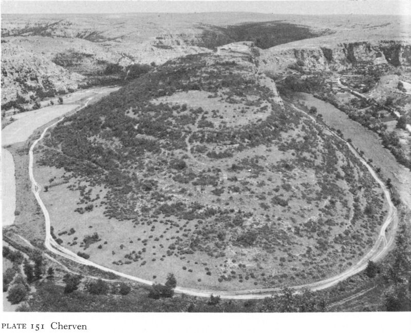
Plate 151 Cherven
The citizens drove the officer away, shut the gates on him, and stood on the walls, loudly praising Maurice and reviling Peter, who beat an ignominious retreat.
Little more than ten years separated the disintegration of the Huns after Attila’s death from the Ostrogothic wars. There is an echo of Ovid’s complaints in Jordanes’ description of the Danube at about this time.
. . . when the wintry cold was at hand, the river Danube was frozen over as usual. For a river like this freezes so hard that it will support like a solid rock an army of foot-soldiers and wagons and sledges and whatsoever vehicles there may be - nor is there need of skiffs and boats. So when Thiudimer, king of the Goths, saw that it was frozen, he led his army across . . . [5]
From 481 until 488, Theodoric the Amal, son of Thiudimer, under a treaty with the emperor Zeno, ruled land which had been within the empire for nearly 500 years; his kingdom covered parts of Moesia Secunda and Dacia Ripensis and his capital was Novae, the old home of Legio I Italica.
Towards the end of the fifth century, large numbers of Isaurian rebels from south-east Anatolia were forcibly resettled in Thracia; it is likely that the depopulated north received many of them. Their presence may explain liturgical
![]()
241
innovations of oriental origin which are reflected in the architecture of some of the churches of this time.
In the sixth century, the policy of defence in depth was intensified. Many Danube fortresses were strengthened and repaired under Anastasius, Justin I, and Justinian, Procopius giving full credit to the last, but increasingly they became isolated outposts. The rapidly diminishing security they could offer spurred the civilian population to depart, a process already begun in the fifth century, especially since they could no longer support themselves by work beyond the walls or by unwanted luxury crafts within them. On fortified hilltop refuges in the Stara Planina and the Ovche hills round Shoumen, existence could be prolonged in conditions of varying comfort or even luxury. In this way, for example, the inhabitants of Sexaginta Prista are said to have evacuated themselves to the naturally defended site of Cherven on the Cherni Lorn river, where below the long-known medieval fortifications, walls of the Early Byzantine period have recently been uncovered (Pl. 151).
Meanwhile, quietly, the Slavs began to fill the deserted northern lands. At first they were probably welcome as a valuable source of agricultural labour and quickly assimilated. Particularly in north-east Bulgaria - at such sites as Nova Cherna, where there was an Early Byzantine fortress, Garvan, and Popina - the many traces of Slav habitation in the sixth century included Christian burials. They were also another source of recruitment; from 530 to 533 a Slav, Hilbud, was a successful commander of the Byzantine forces. But the pressure of numbers became too great to be absorbed and during the second quarter of the century military incursions increased, leading up to a massive invasion in 550 that reached the Aegean coast.
By 586 a new military power, the Avars, described by the Byzantine military historian Michael the Syrian as ‘the accursed barbarians with unkempt hair . . . from the extremities of the Orient’, were established in Pannonia and only held off by annual tribute from invading the empire. Fleeing from their oppression the Slavs surged across the Danube, the border garrisons depleted by wars in Asia. Following the traditions of Byzantine diplomacy, Tiberius II invited the Avars to attack the Slavs from the rear. The Avars came, but not to waste time on the Slavs, with whom they joined forces. John of Ephesus describes the situation:
The accursed people, the Slavs, advanced and invaded the whole of Greece, the environs of Thessalonica and the whole of Thrace. They conquered many towns and fortresses, they ravaged, burned, pillaged and dominated the country, which they inhabited as if it were their own land. This lasted four years, as long as the Basileus [emperor] was making war against the Persians; in this way they had a free run of the country until God drove them out. Their devastations reached as far as the outer walls [of Constantinople]. They took away all the imperial flocks and herds. Now [584] they are still quietly settled in the Roman provinces without anxiety or fear, laying waste, murdering and burning. They grow rich, they possess gold and silver, they possess flocks and horses, and many arms. They have learnt to wage war better than the Byzantines. [6]
The last of the Danubian fortresses fell early in the seventh century. By the middle of the century the hilltop refuges had suffered a similar fate and north
![]()
242
of the Stara Planina only Odessos is known to have remained in Byzantine hands. South of the range there remained Serdica, Philippopolis, Beroe (lost but later retaken), and Mesambria.
The Slavs were no longer invaders; they were occupiers who had made the country their own. There was no question of evicting or conquering them. The Byzantine strongholds possessed a trade and cultural function, as well as a military one, but their role was merely defensive.
The emphasis on destruction during the fifth and sixth centuries inevitably limits the archaeological record and most of the survivals of the Danube limes are Roman rather than Early Byzantine. The latest phase was the first to be demolished, whether by enemy action, decay, or for building materials, and, where reconstruction took place, as often occurred in the medieval period, the Roman remains usually provided the more solid foundation, with the exception of some of the fortifications erected in the first half of the sixth century.
Castra Martis and Ratiaria
Castra Martis was captured by the Huns in 408-9, thereby escaping the terror of Attila, but although it was refortified by the Byzantines in the sixth century and substantial remains exist of the fort at Kula, it seems never to have regained its former prominence. Ratiaria, still a large and rich city in the fifth century, suffered heavily during the Hun invasions. Both cities fell to the Avars.
Bononia
Bononia grew in importance during the fifth and sixth centuries, probably superseding Ratiaria after the Hun invasions. Several sections of the fortress wall of this period, including six towers, have been identified. With four sides of unequal length, they enclosed an area of about 23 hectares. Towers at intervals of about 100 metres were connected by curtain walls with foundations 4.30 metres thick. Bononia suffered heavily from both Huns and Ostrogoths, and Procopius speaks of repairs to its defences. It, too, finally succumbed to the Avars, although there is historical evidence for some limited cultural continuity.
Botevo
Botevo, on the Danube 5 kilometres east of Ratiaria, has archaeological remains indicating a minor settlement or military outpost of the city in the Early Byzantine if not also the Roman period. In 1947 remains were discovered of a small Early Byzantine church of unusual plan - a free cross with arms of slightly unequal length, the eastern terminating in a three-sided apse (Fig. 57). In some places the brick walls were over a metre high; elsewhere only foundations remained. From a west doorway steps led down to a brick floor. Three marble blocks from the altar screen found in situ showed that the sanctuary occupied the whole eastern arm of the cross.
The brick construction and the existence in the debris of sixth-century amphora fragments and Slav pottery suggest a date about the turn of the fifth-sixth centuries. Anastasius’ resettlement of the Isaurian rebels in Thracia at this time might account for the unusual plan. Analogies with the cruciform churches at Tsurkvishte and Ivanyani (p. 279) suggest the possibility of a funerary function.
![]()
243
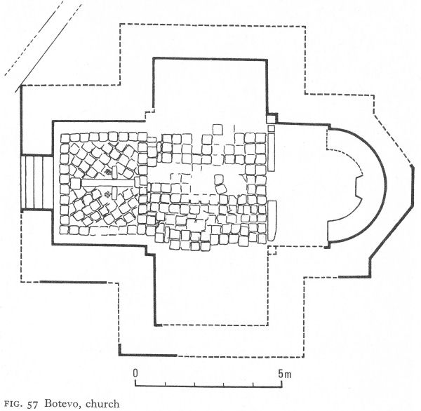
Fig. 57 Botevo, church
Novae
The line of Novae’s original north, south, and west curtain walls and the fourth-century east wall seem generally to have been preserved during the Early Byzantine period, although the inferior building techniques of the later repairs and reconstructions can be clearly detected (Pl. 152). On the east there are signs of one or more walls, in some places inside, in others outside, the main wall excavated (Fig. 21). Some repairs were probably needed following the Hun attacks, but Theodoric’s residence must have preserved Novae from Ostrogothic devastation, and his departure for Ravenna in 488 left it to resume its role as a frontier outpost. Although Procopius mentions some refortification nearby, the city’s defences were apparently sound; no typical sixth-century triangular or pentagonal towers have been uncovered.
In the north-west sector a large building has been partially excavated.
![]()
244
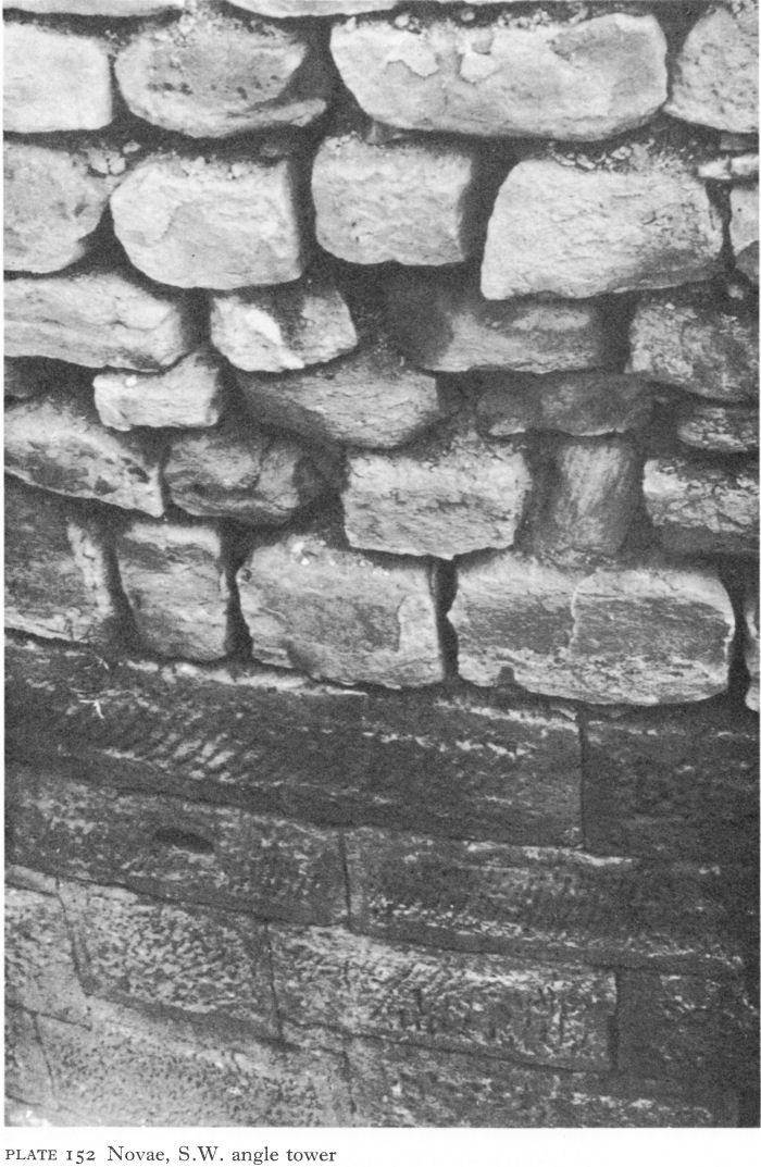
Plate 152 Novae, S.W. angle tower
![]()
245
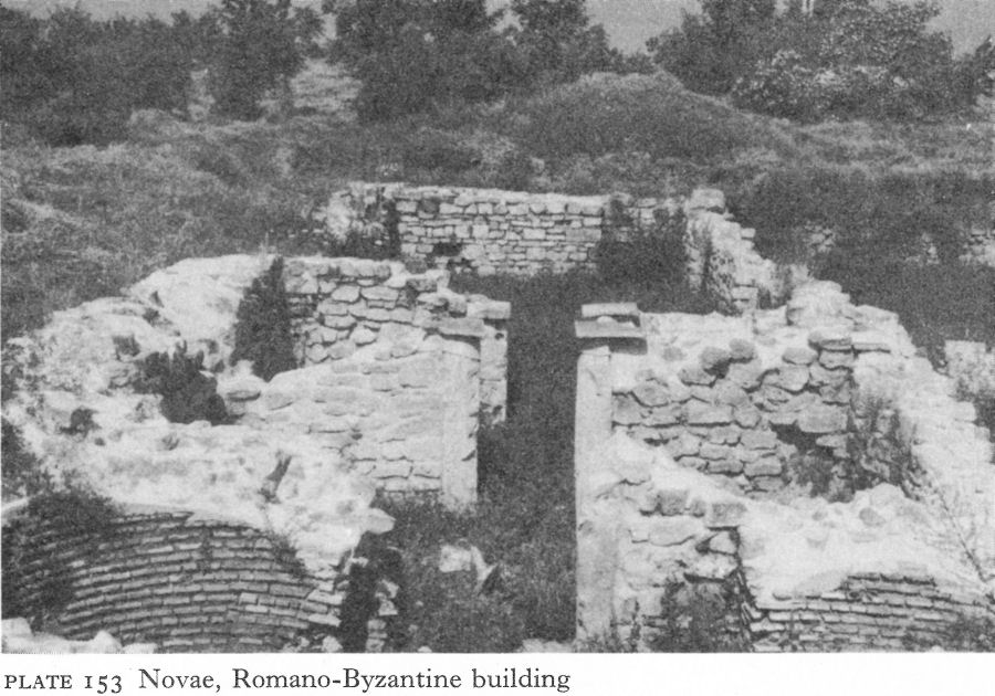
Plate 153 Novae, Romano-Byzantine building
It had a hall with two central piers or columns which led through two narrow rooms to a chamber with two brick-built apses (Pl. 153). The building, its purpose still unclear, was erected during the Roman and reconstructed in the Early Byzantine period.
One church, a much-damaged single-apsed, three-naved basilica, has recently been discovered. Three bishops of Novae, like all others in Moesia Secunda subject to the archbishop of Marcianopolis, are known by name about the mid-fifth century and another, anonymous, is mentioned in 594. The name - and the name only - of one local martyr, St Lupus, has survived through the appearance of Peter, the Byzantine general who fared so ill at Asemus, at Novae on the saint’s feast day; Peter accepted a pressing invitation to remain for the two-day celebrations.
Novae survived into the seventh century but only for a few years.
Iatrus
Iatrus, having escaped damage by the Visigoths, was sacked, probably by the Huns, and occupied by the Ostrogoths in the fifth century.
A church (Basilica 1) was built inside the walls, probably in the last years of the fourth century or early in the fifth (Fig. 26). Three-naved with a single semicircular apse and a narthex, it was 22 metres long, including the 4 1/2-metre-deep apse, and 12 metres wide. The floor was brick-paved and the walls, nearly a metre thick, of opus mixtum with several courses of brick. A Mithraic altar was re-used as building material.
The apse, surviving only to the height of a few centimetres above the floor, contained what was probably the remains of a synthronon - seats round the wall for the clergy - constructed of stone and faced with tiles.
![]()
246
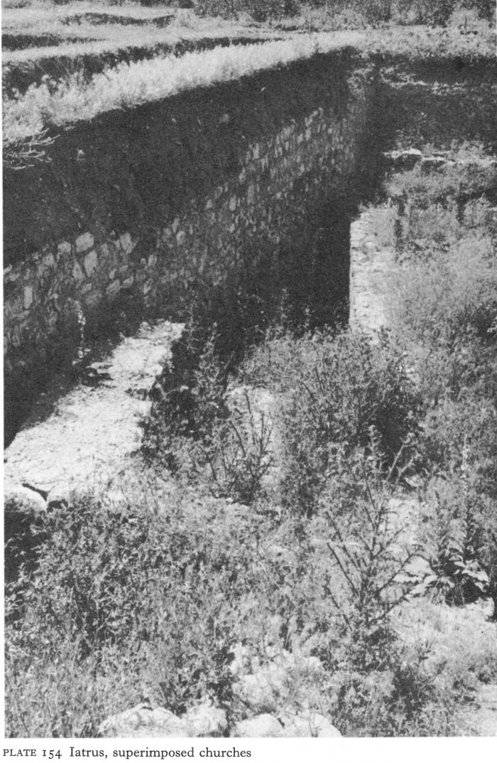
Plate 154 Iatrus, superimposed churches
![]()
247
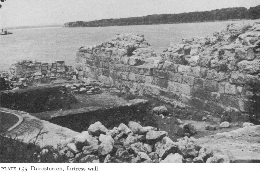
Plate 155 Durostorum, fortress wall
Debris here included fragments of a white marble altar table, its slender columns decorated with stylised acanthus leaves, and a shallow reddish-brown clay dish with a cross stamped in the centre.
Soon after this church was built and before the end of the first quarter of the fifth century, the eastern end of the massive annex in the south-west corner of the fortress wall (p. 134) was demolished to provide space and material for houses. Basilica 1 was burnt down sometime in the fifth century, as well as the two-storeyed rectangular structure and some remaining parts of the south-west annex, when the castellum was sacked.
The wreckage was used as a quarry by the next inhabitants, perhaps Ostrogoths. Fragments of columns, capitals, and bases were used in fifth- or sixth-century houses. One or more were built on top of the church, their stone foundations using its columns and bases but their walls of mud brick. After a time these, too, perished in flames.
Basilica 11, built above the first, was larger and its construction seems to have followed immediately on the destruction of the houses, early in the sixth century. Their debris raised the new floor 1-77 metres above that of the earlier church. Judging by the foundations, which alone remain, the plan was the same as its predecessor’s, an interesting exhibition of conservatism on the part of the inhabitants. Just over 30 metres long without the apse, its substantial walls and stylobates suggest a barrel-vaulted roof.
Iatrus is mentioned by Procopius as a fort repaired in the sixth century, but
![]()
248
its role seems to have changed from that of a military castellum to a fortified refuge for people in the country round about during raids by Avars and Slavs. Excavation has uncovered a group of small, flimsy, single-roomed houses, employing old masonry and architectural fragments but for the most part built of mud bricks, plastered inside with clay. An unusual feature in some of the outer walls was that at about 1-metre intervals the horizontal rows of mud bricks were intersected by a vertical line of similar bricks, apparently performing the function of upright stakes or beams. Wooden beams - some with decorative carving - were, however, used for roofing, covered with reeds or straw and weighted down with heavy tiles. Household goods and tools were relatively primitive.
About the year 600, these humble dwellings, together with the fortifications and any other buildings, perished at the hands of Slavs or Avars in a final conflagration so fierce that the excavated mud bricks had almost the appearance of having been fired in a kiln.
Durostorum
Modern Silistra has far outgrown Durostorum, which remained a rock against which barbarian waves broke in vain until 584 when it fell to the Avars. An inscription suggests that its bishop, Dulcissimus, sought refuge in Odessos, where he died. One of its sons, Aetius, was the imperial general whose victory over Attila in the battle of the Catalaunian plains, near Châlons-sur-Marne, ended the Hun threat to western Europe.
A recent rescue dig in connection with the construction of a new harbour has uncovered parts of an Early Byzantine fortress wall beneath one of the ninth or tenth century [7] (Pl. 155). Otherwise little if anything is known from the Early Byzantine period, but the city seems to have continued some kind of existence until the Bulgar invasion of 681.
NOTES
1. Migne, J. P., Patrologia Graeca, 46, p. 557
2. Priscus, fr. 1b, trans. Gordon, C. D., The Age of Attila, Ann Arbor, 1960, 64, 65.
3. Ibid., fr. 8, 74.
4. Ibid., fr. 5, 67, 68.
5. Jordanes, Getica, LV, 280, trans. Mierow, C. C., Gothic History of Jordanes, Princeton, 1915, 132.
6. Tafrali, O., Thessalonique des origines an XIVe siecle, Paris, 1919, 98, 99.
7. NAG, Arh XII/3, 1970, 81.
11 The Northern Foothills (II)
I. THE CENTRAL SLOPES
Although fortified, the urban centres in the interior of western Moesia Secunda had a fundamentally commercial rather than military function. While they had mainly survived the Visigothic attacks, their economies had been severely disrupted and during and after the Hun and Ostrogothic invasions even survival largely depended on natural defences. If the site was vulnerable, the population, provided they acted in time, moved south to stronger positions in the Stara Planina or beyond.
Nicopolis-ad-Istrum and Veliko Turnovo
Until there are results from the new excavations at Nicopolis-ad-Istrum, the city’s existence after the Visigothic wars must remain an enigma. Its fall is not recorded; it is not even listed as a city attacked by the Huns. Procopius mentions the establishment of a fortress of ‘Nicopolis’ by Justinian, but, as remains of an Early Byzantine fort have recently been reported at Danubian Nikopol, [1] the reference may have been to this site. Bishops of Nicopolis-ad-Istrum are, however, mentioned about 458 and 518. At the time of writing, archaeological evidence is limited to the aerial photograph reproduced in Pl. 94. From this the construction may be deduced of a much smaller fifth-sixth-century fort abutting on to and using part of the south wall, but this reading requires confirmation by excavation.
Sometime after the Visigothic invasions, perhaps gradually, the inhabitants of Nicopolis-ad-Istrum left their city for Veliko Turnovo, where the river Yantra twists and turns through a deep gorge to create a chain of steep-cliffed peninsulas. One of them, the Tsarevets hill, was ideally situated for defence (Fig. 58). Coins of Heraclius and Constantine III show that it survived some fifty years after most of the Moesian fortresses, although it, too, finally perished in flames. Fifthor sixth-century fortifications have also been found on another Turnovo hill, the Momina Krepost, across the river from the Tsarevets.
The discovery that Turnovo was an important Early Byzantine city and not merely a strongpoint in the sixth and seventh centuries stems from the unexpected find in 1961 of an Early Byzantine church and annexed buildings beneath the medieval palace complex on the Tsarevets hill. Later excavations have shown that the whole hill was inhabited during this period. A plan of a three-naved basilical church with a single semicircular apse, a narthex, and remains of mosaics and wall painting, superimposed above a smaller single-naved basilica, was published in 1965 (Fig. 59). [2] Further investigation has now identified as many as four superimposed basilicas on this site close to the north gate and the excavation of other buildings provisionally assigned to the reign of Justinian is in progress. [3] Although the fifth- or sixth-century fortifications were probably levelled to serve as foundations for the medieval walls, a contemporary double gate, the outer portcullis divided by a propugnaculum from the inner swing doors, and a triangular tower nearby have been uncovered.
249
![]()
![]()
250
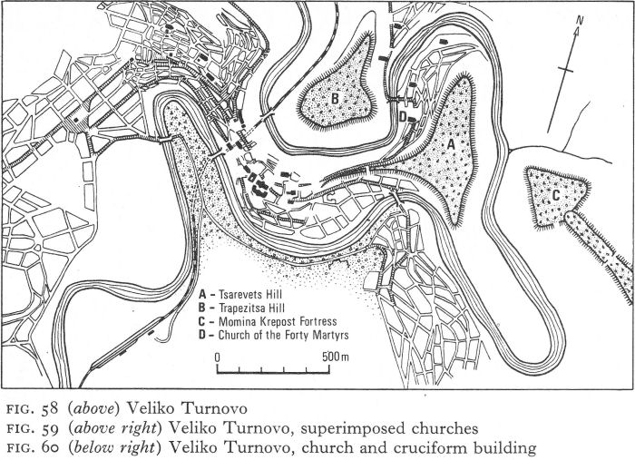
Fig. 58 (above) Veliko Turnovo
Elsewhere below the palace complex was a small single-naved church attached to a cruciform building with a common portico (Fig. 60). Limestone slabs paved part of the floors of both buildings, but there were also remains of tiling. A colonnade on the west of the portico had unequally spaced columns linked by limestone slabs; one intact column, 2 metres high, was discovered with its base in situ on beaten earth. A Corinthian capital was also found, similar to one of several re-used as bases for a wooden portico when the thirteenth-century church of the Forty Martyrs, below the fortress, was converted into a mosque (Pls. 156-8). The cruciform building has a small two-chambered crypt in its partly destroyed eastern part. The excavator dates it and its annexed church to the sixth century and first half of the seventh; he considers it too large for a martyrium, suggesting some connection with other rooms to the south. Nevertheless, on present evidence it is difficult to see it other than as a shrine, built perhaps to house threatened relics from further north.
The distance between Nicopolis and Turnovo is only 18 kilometres, close enough for the population to move without difficulty, given time, and bring their household goods and chattels. Nicopolis was even used as a quarry. Three secondand third-century stelai of Hotnitsa limestone, all depicting a Thracian Horseman, and the base of a statue bearing an inscription from the boule and demos of Nicopolis form part of the socle of a tower of the medieval palace (Pl. 159). In this proximity may be an explanation for the continued existence of the bishopric of Nicopolis into the sixth century. The new city may have been regarded as the official successor of the old, retaining, for a while at least, its ancient name and, in so far as was possible, its administrative functions.
![]()
251
Fig. 59 (above right) Veliko Turnovo, superimposed churches
Fig. 60 (below right) Veliko Turnovo, church and cruciform building
![]()
252
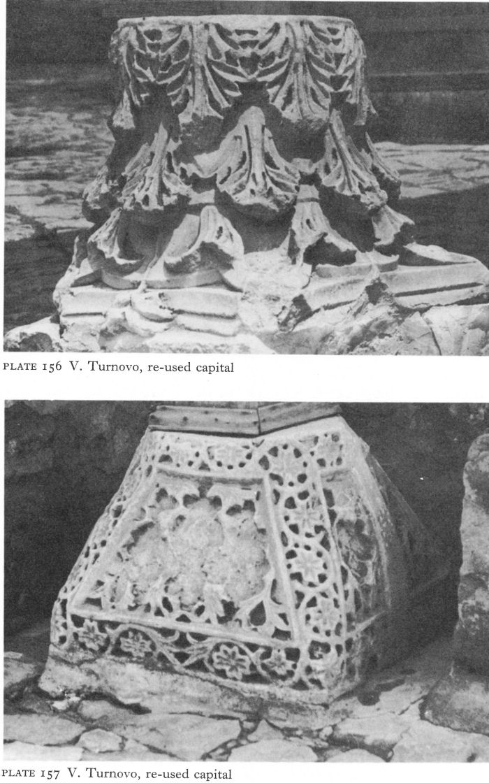
Plate 156 V. Turnovo, re-used capital
Plate 157 V. Turnovo, re-used capital
![]()
253
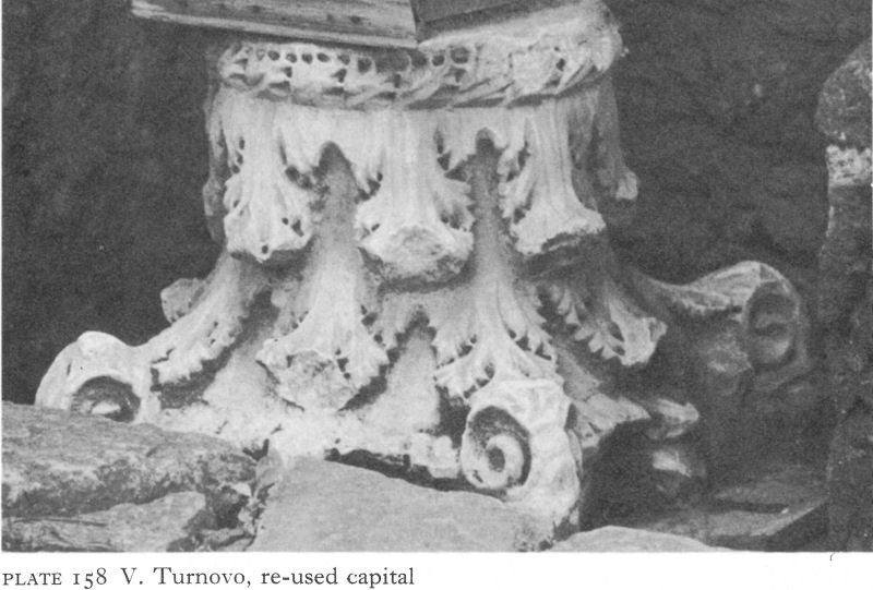
Plate 158 V. Turnovo, re-used capital
Discoduratera
The intrinsic importance of Discoduratera as a trading post on the Beroe-Novae highway persisted as long as traffic continued to pass through it. The merchants returned after the Visigothic wars. Flimsier buildings replaced the porticoed house and its contemporaries, but the outer walls were rebuilt and strengthened. Except where eroded on the south-east by the river Yantra they have survived up to about 1 metre high, through the fortunate chance that they have served as boundaries between peasant properties.
The fortifications took good account of natural advantages. A steep bank down to the Yantra on the south-east, a deep valley to the south-west, marshes to the north-east; only the north-west side was easy of access and here traces of a ditch were found. There were four walls of unequal length, the only gate being on the south-west. External round towers defended the three surviving corners and doubtless the fourth, and single external four-sided towers reinforced each wall (Fig. 61). But Roman precision was gone. The angle towers projected to protect only one, not two, walls, almost as if the builder had heard that round towers were right for corners without understanding why. Yet, although irregular in shape and size, like the rectangular towers they were strongly built. The north tower, partly preserved up to a height of 2.20 metres, is topped by two courses of brick, the remains of a bonding layer.
The much-destroyed gate had inner and outer double swing doors. The openings were over 2 metres wide, large enough to take vehicles, and the propugnaculum about 2 1/2 metres deep. An originally square and free-standing watchtower east of the gate was burnt down and replaced by a rectangular one, built against the outer wall.
![]()
254
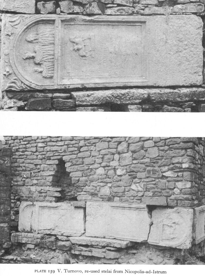
Plate 159 V. Turnovo, re-used stelai from Nicopolis-ad-Istrum
![]()
255
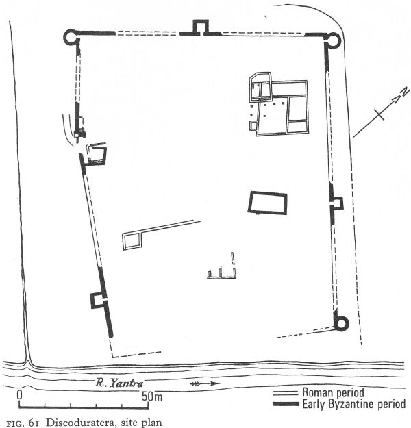
Fig. 61 Discoduratera, site plan
Coins of the end of the fourth century and the first quarter of the fifth are much more numerous than those of earlier periods, but also more worn. This points to a decline in local minting and to inflation, due to the general insecurity and impoverishment. The latest coins are of Arcadius and the Western emperor Honorius.
Sixth-century pottery found inside the walls suggests some continuity after the Hun invasion, perhaps even a revival under Justinian, but the emporium - if such it still was - is unlikely to have outlived him and was finally destroyed by fire.
Storgosia
Storgosia (the ‘Kailuka’ gorge near Pleven) is one of the Roman sites which, though less than 50 kilometres from the Danube, now increased in importance owing to its strong natural defences. Such remnants of fortress walls as can be seen today are medieval, but inside them substantial remains of a large Early Byzantine three-naved church, 45 metres long and 28 metres wide, were discovered in 1909 and have now been conserved and partly restored (Pl. 160).
![]()
256
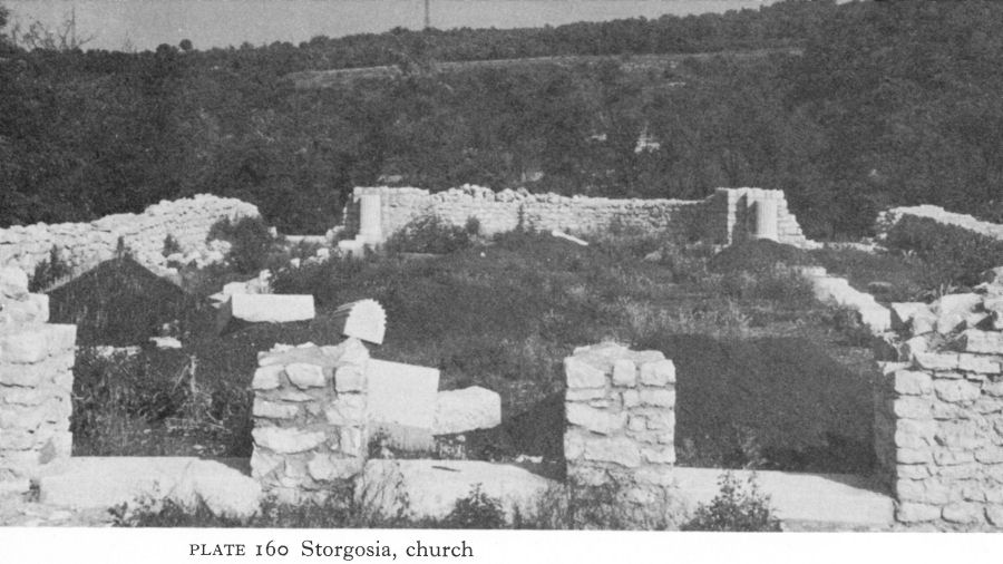
Plate 160 Storgosia, church
The excavator commented on the unusually wide and thick-walled central apse compared with those terminating the north and south aisles. The impression is given of a single-naved church of the fifth century to which side-apses were later added. A large masonry-lined pit, presumably a pool, of the type found in the sixth-century Episcopal church at Caričin Grad in Serbia, occupied much of the atrium, its edge being so close to the west wall as to preclude entry from this direction (Pl. 161). Not only is this one of the largest Early Byzantine basilicas in Bulgaria, but one with unusual architectural features; it is hoped that the conservation will be followed by new and fuller publication.
A smaller building, thought to be a fourthor early fifth-century church, was found at the foot of the cliff, partly eroded by the river. It seems to have been oriented towards a southern apse. Remains of a mosaic floor, no longer in situ, included intricate geometric designs, fragments of a Latin inscription, and the Constantinian labarum, or standard with the sacred monogram of Christ.
A short distance up the little valley, in a building that was possibly a villa of the Roman period, an octagonal structure contained, in addition to some ten human skeletons, 26 bronze coins of Justinian, testifying to Byzantine occupancy until about the middle of the sixth century.
Sadovets
Near Sadovets, south-west of Pleven, the hill-plateau of the Golemanovo Kale overlooks the river Vit in a situation very similar to that of the Kailuka. Inhabited during the Roman period, after destruction in the third or fourth century, it seems to have remained deserted throughout the fifth century and the early part of the sixth.
Coins of Justinian help to date resettlement and the impressive defences (Fig. 62). The southern curve fell vertically from a height of 50 to 70 metres to the river, but the more accessible northern approach was defended by a triple wall. Burnt down once and immediately rebuilt, the fortress survived until its reduction by the Avars about the end of the sixth century, which was followed by permanent abandonment.
![]()
257
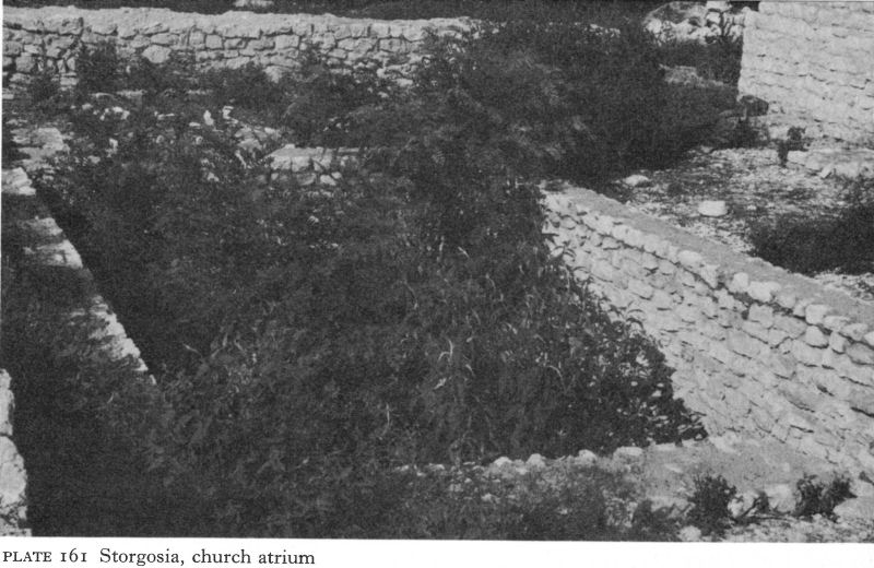
Plate 161 Storgosia, church atrium
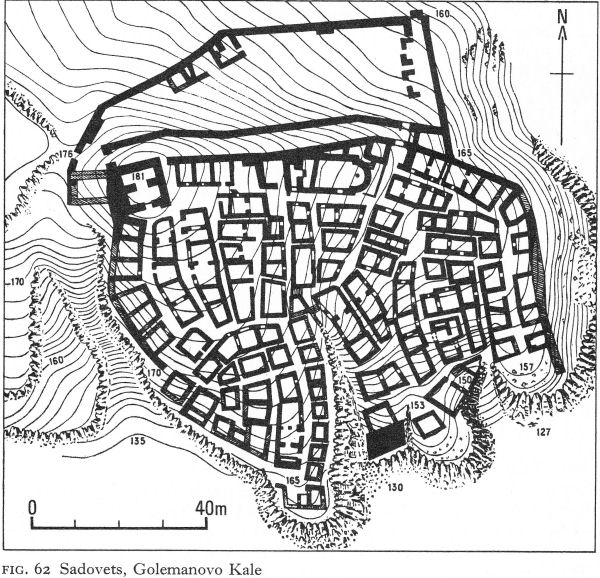
Fig. 62 Sadovets, Golemanovo Kale
![]()
258
The keystone of the defence system was a strongly built tower about 11 metres square which, with a western bastion, occupied the highest, north-western sector. From here three walls, built on a steep slope, itself a deterrent, extended to a fortified section of the east cliff. Entrances, at the eastern and western ends, were only 1.70 metres wide. The walls, with no foundations and 1 1/2 to 2 metres thick, were built of small rough limestone blocks with a filling of rubble and white mortar, the latter also being used to plaster the outer faces. Brick was not used at all.
Behind the triple walls densely packed groups of dwellings, roughly built of limestone bound with mud, were separated by narrow alleys. Many houses had two rooms; one was found with a flimsy upper storey. I. Velkov suggests that one room served as living quarters and the other as a stable or byre, with perhaps a barn overhead for grain or fodder. Elsewhere there were separate rows of individual storerooms. Some people lived on an open terrace below the west wall.
Remains of two churches were found, both single-naved, with rounded apses, one on the terrace, the other in the fortress. The latter was oddly placed, its north-western part against the inner north wall, which cut into it at a slant. It was built on such a steep slope that the interior was on three different levels. The west wall of the church abutted on to an internally projecting tower, so that the main entrance had to be at the west end of the south wall. Much of the altar table was in situ; built of stucco-plastered masonry, its hollow interior must have contained relics. The conch of the apse was of unbaked bricks, but the roof is thought to have been a wooden barrel-vault. The building’s anomalies suggest that the inconvenient site was particularly hallowed.
Sadovsko Kale, a nearby fortified settlement on the other side of the Vit, possessed similar types of dwellings and a large workshop making agricultural tools which must have served the surrounding countryside. Both settlements show signs of wealth incongruous with the rough, huddled dwellings, although these had glazed windows. Silver ornaments, including Gothic-type fibulae, were found, and a remarkable number of coins. V. Velkov states that Sadovsko Kale holds first place in the whole of northern Bulgaria for coins of the late antique period. [4] Fifth-century gold coins - of Arcadius and Honorius - numbered only nineteen, but finds of sixth-century coins included: in one building, 54 gold and 50 copper coins; in a clay pot, 128 gold coins; by a wall, 12 gold coins; in a living room, 162 copper coins. The coins were in such good condition that they suggest direct official payments which never went into general circulation.
I. Velkov and G. Bersu have put forward the interesting theory that Gothic foederati were settled here by Justinian as part of the defence system as well as a repopulation measure. Other settlements in the area await excavation and may confirm this hypothesis.
Vicus Trullensium
The natural fortress of Vicus Trullensium (near Kunino), guarding the entrance to an Iskur gorge through which ran the Oescus-Serdica road, has not been excavated, but inscriptions have identified it. One, on an altar dedicated to Jove, was found in the local church, turned upside down to serve as the altar. The vicus cannot have survived the thirdand fourth-century raids,
![]()
259
but the insecurity of the latter half of the fifth century is likely to have increased the importance of so strategic a site. Earlier fortifications were restored and a double wall built to protect the easy, east approach. Perhaps because of a local tradition of stone masonry, defences were not skimped; walls, whether new or repaired, were up to 2 metres thick. Inside them were remains of a sixth-century single-naved church. The vicus was probably finally destroyed by the Avars, although the Slavs seem to have settled for a time in the ruins before abandoning them for the present site of the village of Kunino.
II. THE NORTH-EAST
A number of sites of strategic importance in the fourth century, but more particularly the fifth and sixth centuries, have been found in a shallow crescent-shaped area, roughly centred on Shoumen, in the hilly country about half-way between Abritus and Marcianopolis. Outposts of the latter, these and other fortresses constituted part of the defence in depth protecting the easy routes across the eastern end of the Stara Planina to Constantinople. In several cases, only a few details have been published in archaeological journals; and thus little more than their existence can be recorded. Nevertheless, the various sites are beginning to compose a coherent pattern illuminating the Byzantine defence strategy of the fifth and sixth centuries. Some of these are described below.
Abritus
The fourth-century town house in the centre of Abritus seems to have remained intact until about the end of the sixth, perhaps an indication that Abritus was occupied peacefully by the Ostrogoths under Theodoric. Two Early Byzantine churches have been located. A. Yavashov found the narthex and west end of the nave and two aisles of one, and a recent salvage dig has uncovered its apse, but finds, which include a marble reliquary, have still to be published. The second church, dated to the fifth century, seems originally to have consisted of a single vaulted nave with a round apse and perhaps also a narthex, but to have had later additions.
Procopius mentions Abritus as one of the fortresses restored or strengthened by Justinian. Either at this time or after further damage the north and south gates were walled up (Figs. 30, 31), leaving the battered west gate as the only entrance. The city was burnt by the Avars or Slavs about the close of the sixth century. Probably the inhabitants had had time to remove themselves and their valuables, for the only skeleton found was of a dog, trapped in the town house’s peristyled courtyard. Before long a group of Slavs settled among the ruins.
Voivoda
In the late fourth century Voivoda was severely damaged by the Visigoths, Following this, current excavations have shown that the north-west gateway was strengthened by a new wall (Fig. 33). This began at the angle tower and ran outside the western U-shaped tower. It incorporated a new outer gate, with two pivoted wings; in a guardroom to its south small copper coins of Theodosius, Marcian, and Leo I were found. The old outer - and now inner - gate, which showed signs of a conflagration, was also strengthened, but neither here nor in the walls did the workmanship approach that of the original structure.
![]()
260
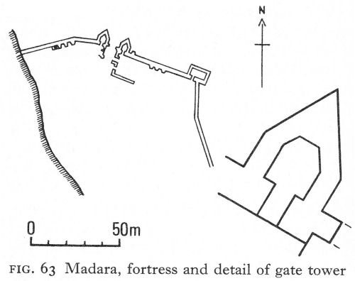
Fig. 63 Madara, fortress and detail of gate tower
Layers of ash and charred material suggest that Voivoda also suffered from many of the later Avar and Slav invasions. The last coins found were of Justin II, indicating its existence into the second half of the sixth century. But finally the fortress was taken and razed. Among the ruins Slav pottery and what the excavators have described as ‘early medieval’ dugouts have been found, suggesting that it was probably soon reoccupied, but by the invaders.
Pliska
Ten kilometres south of Voivoda, with the crow flying over gently rolling country, is Pliska, the site of the first Bulgarian capital. Much excavated and restored since its first identification by K. Škorpil, this vast settlement with its outer city and its inner palace-citadel has been the subject of considerable controversy. Generally, Bulgarian archaeologists have considered it to have been built on virgin soil and any earlier materials, including some bricks bearing the ‘Dules’ stamps, to have been brought from Voivoda or elsewhere for re-use in the new city, but some scholars favour a Roman or Byzantine substratum. Resemblances in the plan of the fortifications of the walled inner city to those of the Justinianic period are clear, but this model must have been available for copying all over the Balkans, and in any case the Bulgars probably used Byzantine builders. Controversy centres also around two churches, one the ‘Palatine church’ inside the walls, the other a huge basilica outside the walled city. Both were certainly used by the Christianised Bulgars; current excavations should decide whether they were also sites of earlier churches.
There can be no doubt that most of the monumental inner complex of Pliska was of eighth-tenth-century construction, but insufficient evidence is available to show whether or not some fifth-sixth-century fort or earlier villa rustica had previously existed there. The site itself, in the middle of a flat, open plain, is more typically Bulgarian or Roman than Early Byzantine and far from fulfilling the usual desideratum in the latter period of a natural defensive position.
![]()
261
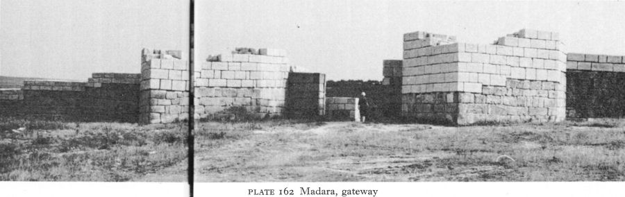
Plate 162 Madara, gateway
Madara
At Madara, about 12 kilometres south of Pliska, the big villa rustica had probably been razed by the Visigoths, but it did not remain deserted. A new complex with five rooms, two exedrae, and heating, all suggesting a baths, was built on the ruins of the wall which had surrounded the pars urbana (Fig. 34). The general plan, the coins, and pottery associated with it date the building to the end of the fourth or the fifth century, but there are signs of habitation until the early sixth, although whether connected with the fort above or with peasants squatting among the ruins is hard to say.
The great cliffs which rise precipitously above the villa are surmounted by a plateau. On its edge, probably in the late fifth or early sixth century, a fortress was constructed (Fig. 63). The sheer cliff on which it stood obviated the need for any walls on the west, and ravines gave some protection on the east and south-east. Only on the north did the open plateau offer no obstruction. This side was defended by a 2.60-metre-thick wall, almost 100 metres long with a projecting rectangular tower at the angle with the east wall. In the centre of the north wall, the fortress gate, flanked by two pentagonal towers (Pl. 162), consisted of an outer portcullis flush with the wall and inner swing doors, with a guardhouse inside. There are remains of several staircases against the inside of the wall.
Almost at the foot of the cliffs a great shallow cave, which had previously been a nymphaeum, was now an auxiliary base, linked to the fort by a staircase of some 400 steps cut in the vertical face of the rock, taking advantage where possible of fissures. Erosion has rendered the route impracticable today. Suitably fortified and itself some way above the plain, the cave provided the garrison with food and water and probably also served as a refuge for the local population and their livestock. Close by in a well-built granary were 11 huge clay dolia, each above a man’s height. Finds showed the granary was in use during the fifth and sixth centuries. Madara was an early and very important Bulgar centre, but there is no evidence when and how Byzantine occupation ceased.
![]()
262
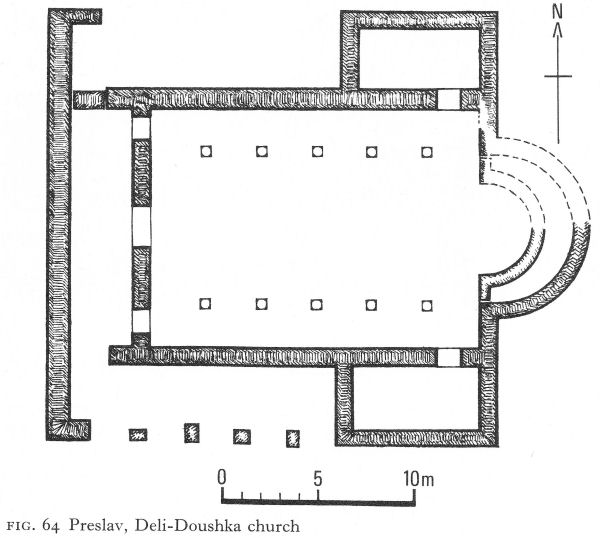
Fig. 64 Preslav, Deli-Doushka church Shoumen
Shoumen
West of Madara is Shoumen, the administrative centre of the region. On a terrace of the high hills dominating the city on the west and looking east and north towards Madara, Pliska, and Voivoda, excavations of a medieval fortress have uncovered some of its earlier history. The preliminary indications are that triangular towers flanked the main entrance to the fortress and were also found at intervals along the curtain wall above older structures. The second - or Early Bulgar - phase is considered to be a restoration of the fourthto sixthcentury structure. Traces of burning everywhere testify to the stormy life led by this fortress.
Long used as a quarry for later buildings, those of earlier periods are naturally much destroyed. However, a large date antique’ complex has recently been discovered and to its west at least three superimposed churches. The earliest, with an overall length of only 10 metres, was single-naved, the walls terminating in a semicircular apse. Only foundations of the western half remained; on the east the superstructure indicated a primitive broken-stone and mud construction, the apse being slightly better built. The simple nature of the building suggests a date in the second half of the fourth century.
Preslav
At Preslav, about 20 kilometres south-west of Shoumen, evidence of late
![]()
263
antique settlement is obscured by the monumental buildings erected when it was the Bulgar capital in the ninth and tenth centuries, and by their subsequent destruction. K. Škorpil, the first excavator of Preslav, said that most of the Roman coins found in the ruins were of the fourth century and that the Early Byzantine period was chiefly represented by those of Justinian, Justin I, and Anastasius. [5]
An exception exists east of the main site, by the Ticha river, at Deli-Doushka, where a fifth-century basilical church has been excavated (Fig. 64). The walls were of mortared uncut stone, with occasional use of dressed blocks to line the entrances; the roof was probably wooden. The wide central nave was separated by rows of five pillars from side-aisles only 2 metres wide. A large single apse corresponded to the width of the nave and contained remains of a synthronon. At the west end three openings led into a narthex, or vestibule possessing liturgical functions. Two rectangular pastophoria or side chambers, entered from the east ends of the two aisles, are of special interest as they must have served as the prothesis and the diaconicon, rooms designed respectively for the preparation of the Eucharist and as a vestry or sacristy in the Eastern Orthodox rite. Coins date the church to the first half of the fifth century, more than a hundred years before the Orthodox rites of oriental, particularly Syrian, origin found official recognition in Constantinople, a fact suggesting strong Eastern influence among the local population, a proportion of whom may have been immigrants.
Preslav is situated where the river Ticha emerges from a gorge into a fertile plain. On a hill commanding the entrance to the gorge, Early Byzantine potsherds were found among the ruins of a Bulgar fort which, roughly oval in shape, had one square and one round tower. It was concluded that this site - an obvious choice - had been fortified in the fifth or the first half of the sixth century.
Draganovets
On a tributary of the Ticha river some 15 kilometres south-west of Preslav, a rescue dig recently uncovered a fortress provisionally dated from the mid-third century to the end of the sixth.
Partial excavation of a church dated to the fifth or sixth century showed a long apsed room annexed to the south side of a three-naved, single-apsed basilica. The excavators’ suggestion of the possibility of a five-naved basilica must be regarded as tentative until more information is available. Stone and mud walls of an earlier building were found beneath the church and were identified by finds of marble votive reliefs as a sanctuary of the Thracian Horseman. A double furnace for brick-making, dated to the fourth or fifth century, was also excavated.
Krumovo Kale
At the western end of the Preslav hills, near Turgovishte, a fort known as Krumovo Kale defended the northern end of a pass and commanded a wide view towards Abritus. Enclosing an area of about 15-20 dekas (dekars?), the walls, 2.50 to 2.80 metres thick and still standing up to 3.50 metres high, were built of stones laid in regular courses and a fill of rubble and mortar. Remains of mortar over the stones, with incised vertical and horizontal lines, gave an impression of dressed stonework. The single gate, facing the only easy approach, was 3.70 metres wide and the depth of the curtain wall; it had pivoted wing doors and finds of wedge-shaped bricks show that it was vaulted. U-shaped towers defended the
![]()
264
gate, the south one being 6.80 metres wide and projecting perpendicularly 5.30 metres beyond the wall. The northern, almost identical in size, was angled away from the gate towards the saddle on which the access road is still visible. Both towers were constructionally linked to the wall and remains of stairs suggest an original height of about 12 metres.
Excavation showed two building phases, both within the Early Byzantine period. Although the plan remained the same, in the second the stonework was much less skilful; there was no longer an attempt at regular courses and large limestone slabs were re-used in the gateway. The U-shaped towers - inferior in size and construction to those of Abritus and Voivoda - suggest a date about the mid-fifth century for their construction. As the culture layer is very thin, the first destroyers may have been the Ostrogoths. Restoration followed quickly, probably in the first half of the sixth century. Supporting evidence comes from the remains of a three-naved church only 2-3 metres inside the walls and closely related to them. The second phase of the church is well dated by coins of Justinian. At this period the church, 28 metres long and almost 16 metres wide, had a single apse, its exterior five-sided and containing a concentric ambulatory behind a synthronon. Columns on stylobates separated the nave and aisles, and the narthex was undivided. Since this church has not been published in any detail, it can only be assumed that, like the walls the second phase was more or less a reconstruction of the first, with a possible remodelling of the apse.
North of the walls fortified outposts served as observation points. Round these a civilian settlement grew up, probably for craftsmen and small traders. It included a single-naved church on the edge of a cliff about 300 metres north of the walls (Fig. 65). The lower parts of its walls were of broken sandstone, the upper of mud brick, probably reinforced by a wooden frame. The sanctuary, an adaptation of the Hellenistic basilica to the Eastern rites which required pastophoria, comprised the apse and 2 1/2 metres of the east end of the nave, partitioned into three and slightly higher than the rest of the church. Because of the steep drop outside, there was no narthex and the entrance was by the west end of the south wall. The church was paved with irregular sandstone blocks in the pastophoria and re-used tiles elsewhere.
Evidence from the walls suggests that this church had also been rebuilt after severe destruction; a chronology according generally with that of the fort seems likely. Coin finds suggest that Krumovo Kale survived well into the second half of the sixth century.
Tsar Krum
Near the village of Tsar Krum, 10 kilometres south-west of Shoumen and on a slight rise 2 kilometres from the river Kamchiya, excavation of a ninth-century Bulgar fortress unexpectedly uncovered three Early Byzantine churches. Two, superimposed, are just inside the north wall of the fortress, the third a short way away to the south-west.
The lower of the superimposed churches, destroyed by fire and much of its material re-used in the one above, was a small basilica only 9 metres long (Fig. 66). The ovoid apse contained a single-stepped synthronon. The nave was flanked by stylobates, each with three pillars, leaving ‘aisles’ no more than half a metre wide. The narthex, severely damaged, appears to be undivided.
![]()
265
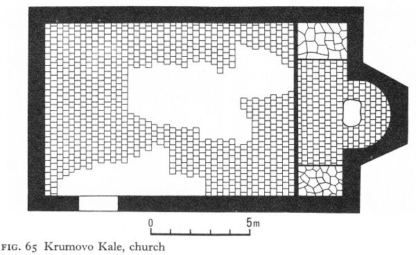
Fig. 65 Krumovo Kale, church
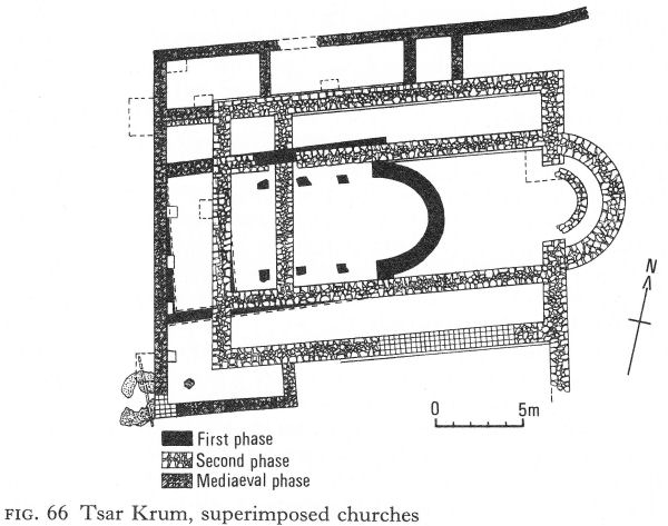
Fig. 66 Tsar Krum, superimposed churches
Tiles were found from the roof and the floor was brick. The plan of the church, its relationship with the one above - a depth of 1 metre between the two floor levels - and finds of ceramic and fourth-century bronze coins show this to be one of the earliest churches in Bulgaria. Fragments of wall paintings add to its especial interest.
Most of these fragments, some with three layers of paint, were in the 60-centimetre-thick debris that covered the floor of nave and apse, but others, apparently parts of panels, were in situ at the bases of the walls.
![]()
266
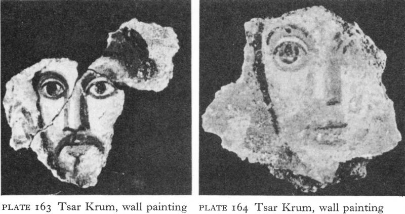
Plate 163 Tsar Krum, wall painting
Plate 164 Tsar Krum, wall painting
Most important were fragments of almost life-size human faces, two nearly complete and the fresh colours extraordinarily well preserved. One shows the head, turning slightly to his right, of a man, perhaps in his forties, with brown hair, a drooping moustache, and a short beard. His large eyes and his nose and mouth are firmly modelled with pinkish-orange and brown strokes. The background is blue and an acanthus leaf can be seen behind the right cheek (Pl. 163). The second head is of a younger, beardless man (Pl. 164).
It is hardly possible that more than fifty years divide these paintings from those in the tomb at Durostorum; they may even be contemporary. The colouring is somewhat similar, but spirit and techniques are quite different. The Durostorum figures are portrayed in a realistic, Roman manner. The spiritual quality of the Tsar Krum heads places them unquestionably in the full tradition of Byzantine sacred art. These recently discovered paintings are important examples of an art of which very little survives from this early period. Relationship with the Hellenistic East seems evident; there are certain resemblances with the earliest - fifth- to seventh-century - icons at Mount Sinai.
According to pottery and building remains, this church lasted until the late fourth century, when it may have been a casualty of the Visigothic wars. V. Antonova has tentatively placed its construction within the first half of the fourth century; it can scarcely be later, given the three identified layers of wall painting.
The second church to be built was the one a short distance away, a singlenaved basilica without a narthex (Fig. 67). The apse was unusual in that its slightly horseshoe-shaped ends - an Anatolian feature - extend 2 metres within and alongside the walls of the nave, perhaps to buttress the vault of the apse. The base of an altar screen was found at the beginning of the apse but did not extend across it; the stone base of an altar table stood in the centre of the sanctuary. The floor was of old, often broken, tiles, laid directly on the earth. The west wall continued south and then turned eastward at a right angle, a feature also found in the Deli-Doushka church. It suggests a wooden portico and this is made more
![]()
267
likely by the presence of a south doorway inlo the church. The roof was tiled on a wooden framework. The general plan, pottery finds, and coins of Constantius and Honorius assign this church to the late fourth or early fifth century.
The third church was on top of the first, on almost the same axis (Fig. 66). Although much larger, it was similarly planned, with a relatively wide nave in proportion to the aisles. Its semicircular apse contained a single-stepped synthronon. The nave and aisles were divided by stylobates, but all the columns had been removed. The outer walls, preserved in places up to 1.40 metres, were 1.30 metres thick. A southern extension of the east wall may have been needed as a buttress or been the enclosing wall of a portico. A bonding layer of three courses of yellow brick was found above the stone masonry at one point. The narthex was tripartite, corresponding to the nave and aisles. This essentially Hellenistic basilica is elongated compared with the Deli-Doushka church and lacks its side-chambers. Both churches, as well as the one below, reflect the variety of influences in this region in the fifth century, to which this last church must be dated. The contrast with those at Iatrus is strong.
Although damaged, the stout walls of the third church survived the Slav settlement and even incorporation into the fortress of the pagan Bulgar ruler Omurtag. Its cult purpose was either remembered or later recognised, for towards the end of the ninth or in the tenth century it was restored and enlarged by Christians in the first Bulgar state.
Marcianopolis
Marcianopolis withstood the Visigoths, but their devastations of the surrounding countryside caused the city to undergo a period of decline, reflected in constructions attributed to the late fourth and fifth centuries.
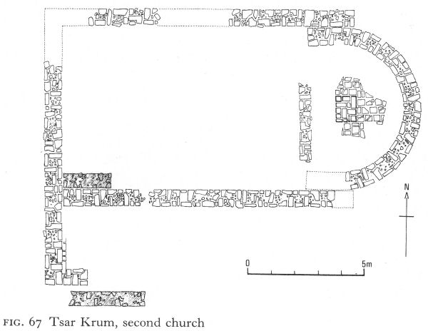
Fig. 67 Tsar Krum, second church
![]()
268
Nevertheless, the state munitions factory is believed to have continued to function until at least the mid-fifth century, and a pottery for making Christian lamps is also dated to this time. The only early - late fourth- or early fifth-century - church so far identified is single-naved with a mosaic floor, although Marcianopolis was an archiepiscopal centre as well as the capital of Moesia Secunda. Two painted tombs from the necropolis with decorations that included garlands and doves may also belong to this period, which came to an end in 447 when the Huns captured and set fire to the city.
The city was to have a brief flowering in the sixth century. According to Procopius, its walls were restored by Justinian, and the remains of four churches have been attributed to this period. One, superimposed on the early single-naved basilica, was three-naved, with a narthex and a rectangular annex, believed to be a baptistery. The nave was separated from the aisles by marble columns, each with a cross carved in relief in the middle, crowned by acanthus capitals, one incorporating an eagle. In the nave, in front of the sanctuary, the mosaic floor was almost completely preserved. Using stone and ceramic tesserae of white, black, brown, orange, and yellow, zones of interlacing flanked geometrically patterned squares in kilim-like fashion.
In the arena of the destroyed amphitheatre another three-naved basilica was erected, using much of the old building material. Perhaps this site was chosen in commemoration of martyrs who had earlier met their deaths there.
So Marcianopolis, a strategic bulwark in the defence of Constantinople, enjoyed prosperity until the second half of the sixth century, when it was taken by the Avars, but probably more plundered than destroyed, since it is mentioned in 595 as a military base visited from Odessos by Peter, brother of Maurice.
The last mention of the archbishopric of Marcianopolis was in the seventh century, after which it seems to have been transferred for a short time to Odessos. The title was resurrected a thousand years later, when Pope Urban VII appointed one Marko Bandulević (perhaps a Bosnian) to the archiepiscopate of the Catholics in north-east Bulgaria and some lands beyond the Danube, and gave him the title of archbishop of Marcianopolis.
NOTES
1. NAC 1970, Arh XII/3, 81.
2. Miyatev, K., Arhitekturata v srednovekovna Bulgariya, Sofia, 1965, fig. 148.
3. BASEE I, 1969, 51, 52.
4. Velkov, V., Gradut v Trakiya i Dakiya prez kusnata antichnost, Sofia, 1959, 164.
5. Škorpil, K., in Bidgariya 1000 Godini, I, Sofia, 1930, 186.
12 Serdica and the West (II)
I. SERDICA AND THE CENTRAL REGION
The fourth-century extension of Serdica’s fortifications was probably destroyed by the Visigoths in the last quarter of the same century, and the fall of the city to Attila’s Huns in 441-42 put an end to any question of its reconstruction. Serdica was sacked and looted; the destruction was less severe than at Naissus, but at a meeting here in 449 between Byzantine and Hun envoys, the latter could still point to the surrounding devastation to illustrate their master’s power.
After Attila’s death, Serdica’s walls must have been hurriedly repaired - or else the city would have been defenceless during the ensuing Ostrogothic wars - but the original Aurelian plan was readopted and continued during the sixth century. Then or, it has been suggested, as early as the reigns of Marcian I or Leo I, a massive renovation of the city’s defences was part of the general refortification programme. A new wall was built along the whole outer face of the old one, the socle of which formed part of its base. Like the old wall, it was 2.15 metres thick, except on the south where it was 2.60 metres. The strength of the walls was thus doubled (Fig. 68). Although earlier rounded towers were incorporated in the new curtain wall, triangular and pentagonal towers were added, especially by the two gates, as can be seen by the east gate in the pedestrian underpass (Pl. 165).
There is no evidence how Serdica fared at the hands of the Avars and Slavs, but it appears to have remained in Byzantine hands, reappearing in history at the beginning of the ninth century, when the Bulgars captured it and dismantled the fortifications before retiring.
The insula east of the St George complex underwent little change. Sometime, what had probably been a pagan shrine in the form of an inscribed octagon was converted to Christianity and given a rounded eastern apse. A small single-naved basilica, also with a rounded apse, was attached to it.
Outside the east gate were two churches, one above the other, a baptistery beside them (Fig. 69). The earlier church, single-naved but with pastophorialike annexes, an apse almost as wide as the nave, and a narthex where a fragment of geometric mural painting has survived, recalls Deli-Doushka. Dated to the fourth century, it was probably destroyed by the Visigoths. Its successor was an early fifth-century type of basilica with walls of opus mixtum, stylobates carrying colonnades, and a massive rounded apse with a single-stepped synthronon. The two-roomed baptistery, 2 1/2 metres from the earlier church and 5 metres from the later, was not precisely aligned with either. East of the piscina, which had three steps at either end, an apse had been bricked up to form a semicircular basin reaching down to the floor, perhaps some kind of stoup for holy water. Although fourth-century coins were found, the baptistery is considered on a variety of grounds to belong to the later church. [1]
A few hundred metres away along the road to Philippopolis was the city’s main Early Byzantine necropolis, marked today by the church of the Holy Wisdom (Sophia), the fifth church to occupy the site (Pl. 166).
269
![]()
![]()
270
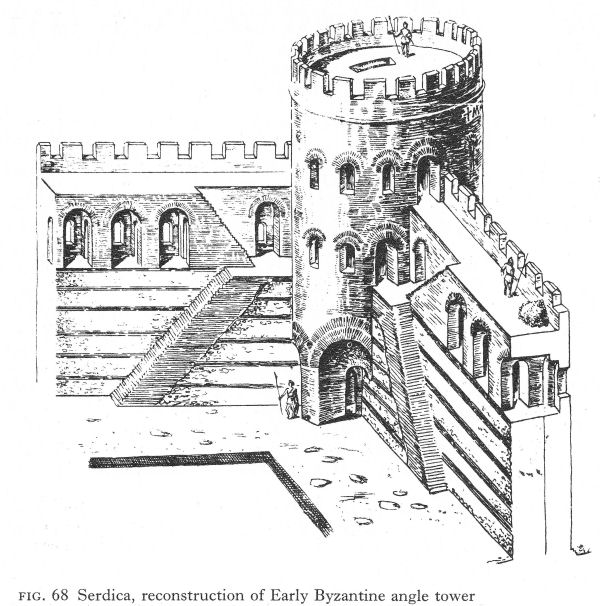
Fig. 68 Serdica, reconstruction of Early Byzantine angle tower
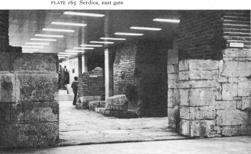
Plate 165 Serdica, east gate
![]()
271
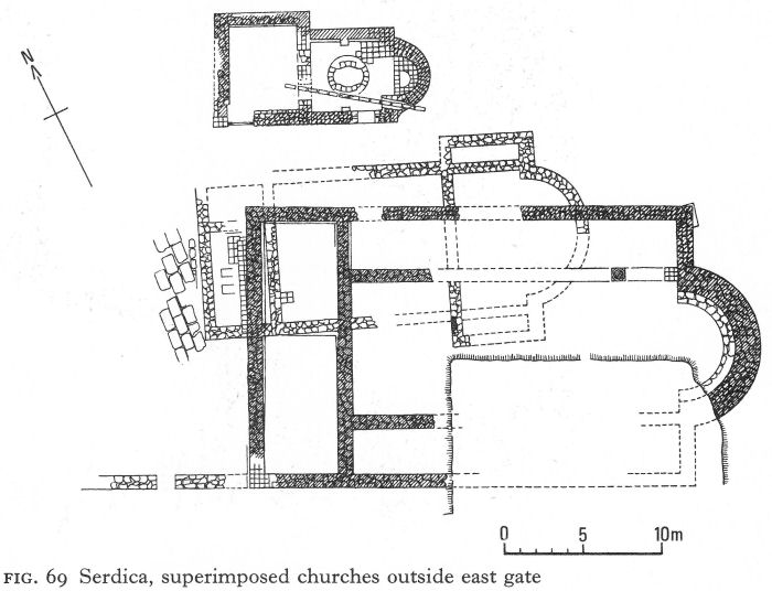
Fig. 69 Serdica, superimposed churches outside east gate
Patched but dignified, this ancient basilica carries its years with a modesty in sharp contrast to the gleaming golden-domed nineteenth-century church of Alexander Nevski standing nearby.
Alongside third-century pagan graves, Christian burials began to take place here in the first half of the fourth century. A concentration, among them tombs with painted vaults, was found under and close to the church of Holy Wisdom, clearly intended to be as near the original church as possible. They are architecturally similar and have the same reddish-orange painted frames round the walls as the contemporary pagan one at Durostorum. Facing birds and tree motifs are common to the paintings of both, but in Serdica the lighted candles flank a labarum. On one vault poppies replace rural scenes.
The finest painted tomb here was found in 1909. Brick built and vaulted with a north-south orientation, it had been looted and was badly damaged by damp. The walls were painted to imitate marble revetment. In the centre of the ceiling a green laurel wreath with white fruit enclosed a Latin cross in yellow ochre, outlined with pearls and with white rays radiating from its centre. Busts of the four archangels, named in Latin, occupied each angle of the long sides of the vault. Three were in a very poor condition and only Uriel was photographed before disintegration (Pl. 167). The excavators dated the paintings on stylistic grounds to the fifth or possibly sixth century, but Latin suggests the fourth, and the orientation of the tomb also argues for an earlier dating. [2]
The first church on the site of Holy Wisdom (Fig. 70), single-naved with a rounded apse, occupied an area about 14 metres long and nearly six metres wide under the east part of the present church.
![]()
272
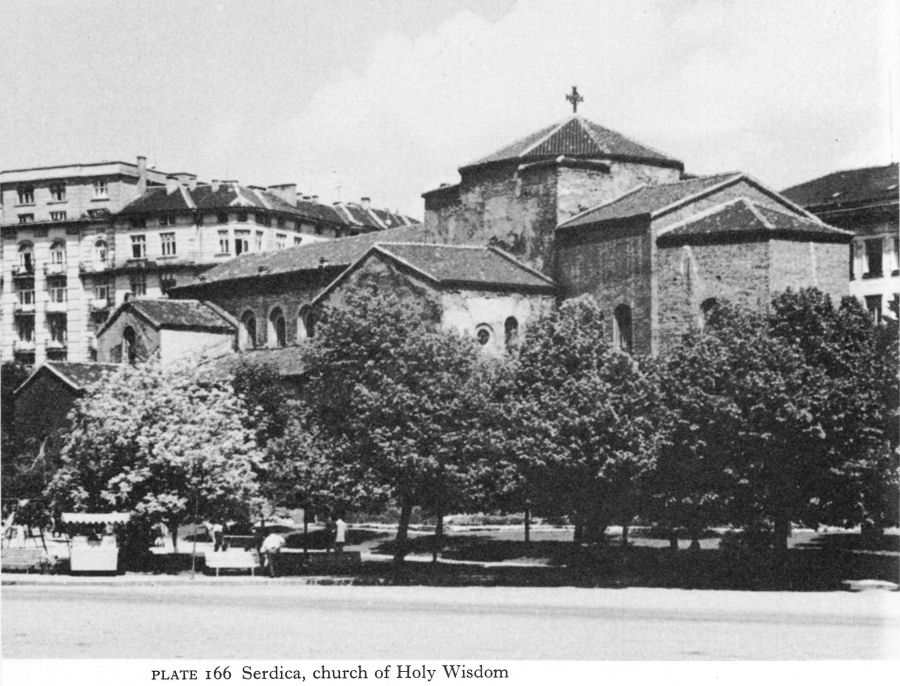
Plate 166 Serdica, church of Holy Wisdom
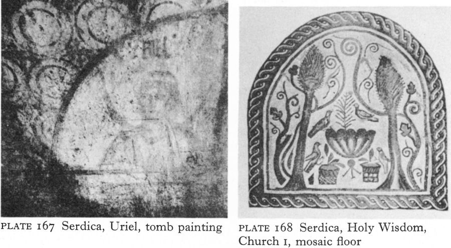
Plate 167 Serdica, Uriel, tomb painting
Plate 168 Serdica, Holy Wisdom, Church 1, mosaic floor
![]()
273
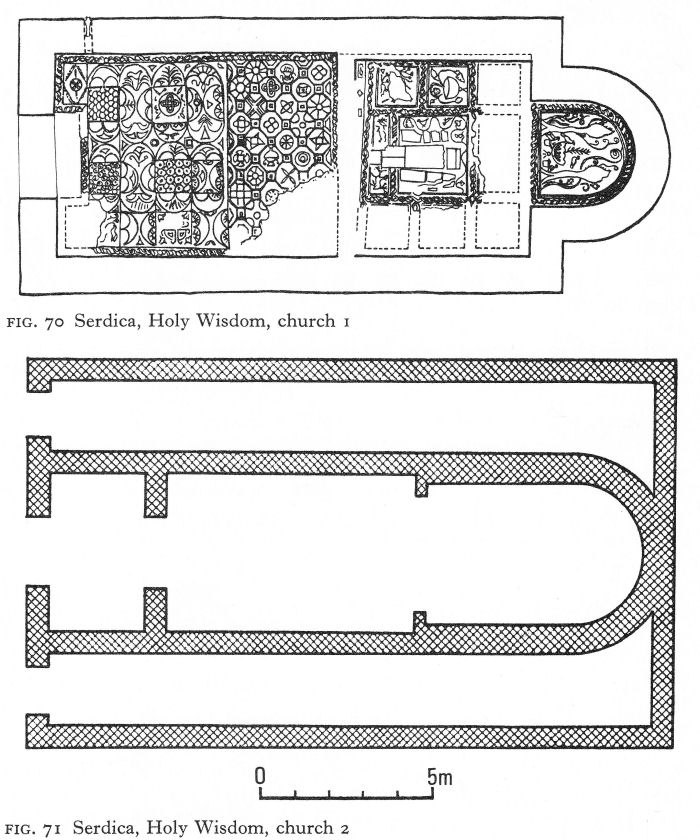
Fig. 70 Serdica, Holy Wisdom, church 1
Fig. 71 Serdica, Holy Wisdom, church 2
Only mortar foundations of its first pebble mosaic floor remain. The next floor was of multicoloured mosaic tesserae, divided into three zones and probably used during more than one building phase. In the centre of the apse zone, birds perched round a large fluted bowl, plant, and two baskets, were flanked by cypress-like trees and spiralling vines (Pl. 168). The next zone, occupying rather more than the eastern third of the nave, was square, its subdivisions containing such common symbols as the vine, ivy, lambs, and a peacock. Beyond, a single border enclosed the third zone, divided into two parts; the western had complex and luxuriant geometric patterns, with here and there a vase and once a bird, the more schematic and regular eastern part being considered a later repair.
![]()
274
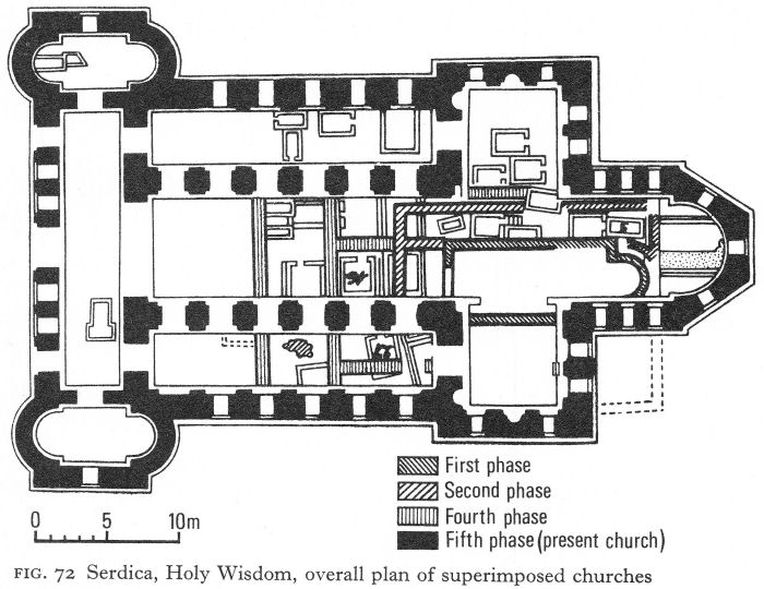
Fig. 72 Serdica, Holy Wisdom, overall plan of superimposed churches
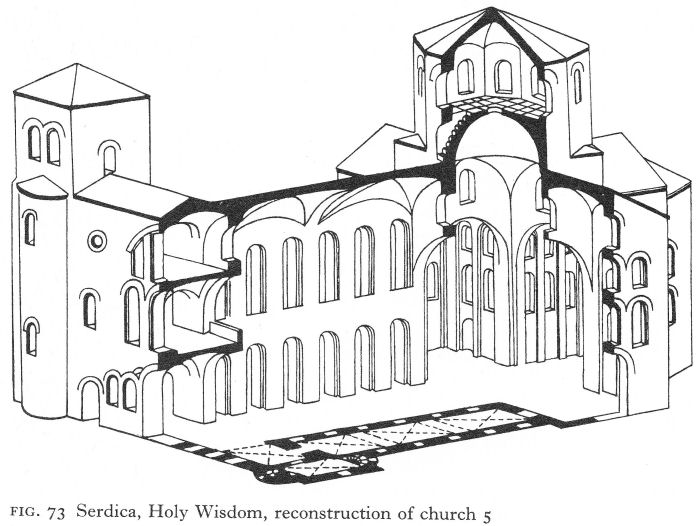
Fig. 73 Serdica, Holy Wisdom, reconstruction of church 5
![]()
275
The nave of the second church was built on the foundations of the first, but with two side-aisles to north and south extending to a new east wall which inscribed the apse, now as wide as the nave. A tripartite narthex was added (Fig. 71). The repaired part of the mosaic floor of the first church may have belonged to its successor or the whole floor may have been common to both buildings.
The third church widened the aisles and narthex of its predecessor; the few remains include new fragments of mosaic, also with geometric designs but using larger tesserae with less skill.
The fourth church (in B. Filov’s 1913 excavation report the second) is a puzzle, the first clue being the existence of a floor mosaic above the earlier levels. Including damaged areas, but without borders, which have entirely disappeared, this mosaic covered nearly 144 square metres and paved part of the nave. More was found at the same level in the south-east corner of the south transept. Here was perhaps the beginning of an edge to the floor. In 1913 the plan of the church was impossible to determine. The south aisle of the present building, then in use as a chapel, could not be excavated. Nevertheless, Filov suggested that two parallel north-south walls, running near or under the second and fourth piers (counting from the west), seemed to correspond to the narthex of a single building, and proposed that a similar wall between the north piers supporting the dome might be part of its north wall. The overall plan published after recent conservation (Fig. 72) supports these theories and suggests stylobates along the middle of the present nave and south aisle. Pending fuller publication, no further analysis is possible.
The fifth church, although mutilated by eventful centuries, is in essentials the one standing today. The building has been variously dated between the fifth and twelfth centuries, and described as influenced by Anatolian or Romanesque architecture, or even as having influenced the evolution of the Romanesque, the Crusaders acting as ‘carriers’ in either direction. Some of these theories may be due to the splendid soaring height of the nave which is a familiar sight to the Western eye.
Much larger and more solidly built than its predecessors, the new church was wholly brick. Beginning from the west, the ground plan consisted of an undivided narthex with north and south extensions, a nave and two aisles, a slightly protruding transept, and finally a short choir and an apse with a three-sided exterior. The total length was 46 1/2 metres, of which the nave and aisles occupied only 21 metres. In spatial terms, the church gives less the impression of a three-naved basilica than of a Latin cross with an architecturally integrated narthex and vaulted and galleried side-aisles.
The high vaulted nave is separated from the aisles by massive arched piers, five on each side, spaced only 1-70 metres apart. The openings from narthex and transept are little wider, establishing a great contrast between these relatively shut-in areas and the broad lofty space formed by the integral and apparently uninterrupted unit of the nave, transept, and choir-apse. Separation of aisles from nave is not at all unusual in fifth- and early sixth-century basilicas; but, where a trans ept exists, its arms are normally occupied by the prothesis and diaconicon.
![]()
276
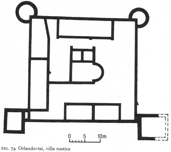
Fig. 74 Orlandovtsi, villa rustica
The plan shows that the transept did not serve this purpose here, consequently the sanctuary consisted of the choir and apse. The funerary church of Holy Wisdom thus provided a suitable position beneath the dome for the deceased during the burial service.
A similar plan was found in another funerary church nearby at Ivanyani. Analogous cruciform churches with a less clearly defined function have been excavated at Tsurkvishte, and at Caričin Grad in Serbia. [3] Possibly Botevo (p. 242) falls within this category. This plan was by no means the sole funerary type; probably of eastern Anatolian origin it occurs in the Balkans only in a relatively small area.
The Holy Wisdom stood, exposed, outside the walls on a site where at least four predecessors had been destroyed within two or three hundred years. There were many graves, perhaps some of martyrs, beneath the floor and the church itself must have contained much of spiritual and material value. Hence its solid construction, calculated to withstand minor raids. Galleries, perhaps for defence as much as for worship, were built above the narthex and transept as well as over the aisles. It is now believed that there was a second storey above the narthex and transept, and that the north and south extensions of the former carried towers (Fig. 83). Cross-groined vaults covered the transept arms and choir, and also formed the ceiling of the nave and aisles. The present dome,
![]()
277
supported on four piers, has no drum, but S. Boyadjiev has proposed that originally a dome on an octagonal drum rose in place of the one visible today. [4]
Finds of 23 coins, ranging from Licinius to Arcadius, between the upper and lower mosaic floors give some help in dating the earlier churches. The first may have been built soon after the Edicts of Toleration - not unlikely if martyrs had been buried there. Historically feasible periods of destruction are the reign of Julian the Apostate, the late fourth-century Visigothic war, and the sack of Serdica by the Huns in 441-42. Julian passed by in 361 on the road from Naissus to Constantinople, where he was proclaimed emperor; his supporters might have razed the church to gain favour. It was an easy target for Visigoths and Huns. Added to these possibilities were natural disasters, such as fires, to necessitate rebuilding, as well as a fashion for new and larger churches. All that can be said with reasonable certainty is that the first four churches were built between the first half of the fourth and the middle of the fifth centuries.
The late fifth century, after the Hun and Ostrogoth devastations, was an unpropitious time for building the present church. Such skilful brick construction - especially in an exposed situation - is most unlikely in the late sixth century, yet the influence of Justinian is not evident in the massive, though noble, simplicity of the interior. On the whole, the first quarter of the sixth century seems most probable.
Even if Serdica remained a Byzantine outpost until the ninth century, a church so far outside the walls is unlikely to have been kept in repair. There is some slight epigraphic evidence for restoration in the late tenth or the eleventh century. Yet its fame grew. A charter granted to the monastery of Dragalevtsi in 1382 refers to the ‘region of the Holy Sophia' and in the course of time Serdica, after being ‘Sredets’ to the Slavs, took the name of its most renowned church.
The necropolis had other churches. The foundations of a single-naved basilica with a round apse and a narthex, in all 16 metres long and 5.60 metres wide, were found 12 metres south of Holy Wisdom. Another, only partly excavated, lay to its west.
Orlandovtsi
The environs of Early Byzantine Serdica were not wholly cimiterial. Villae rusticae of the late fourth and fifth centuries have been uncovered, but the open aspect of more peaceful days has gone. An unusually fortified villa was found in 1935 at Orlandovtsi, 4 or 5 kilometres outside the city. The walls, preserved up to a metre high, formed a rectangle measuring 31 by 34 metres (Fig. 74). Two round angle towers projected at the north-west and north-east corners, whilst the south-west and south-east corners were defended by external rectangular towers. Built of local broken stone and mortar, the walls were 65 to 70 centimetres thick, except at the towers, where they approached 1 metre.
The site had been long under the plough so that, although the plan was clearly discernible, there were few finds in situ to help determine the interior arrangement. Rooms were annexed to the walls on all sides except the east. The west was completely occupied by a rough construction, divided into two parts, probably farm buildings. On the south were two smaller rooms, probably living quarters; they were better built and contained materials apparently brought from Serdica,
![]()
278
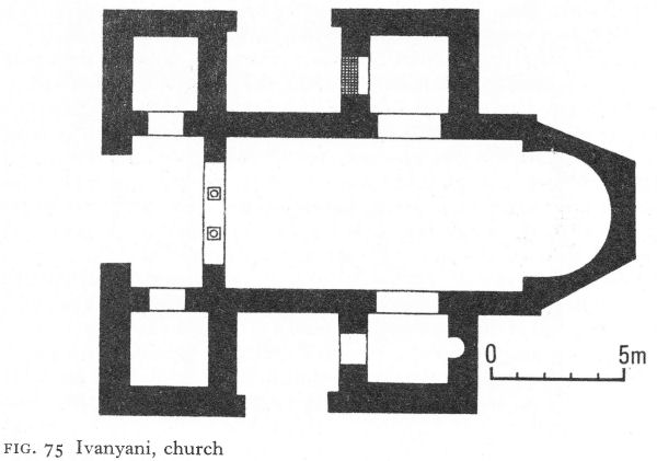
Fig. 75 Ivanyani, church
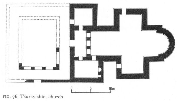
Fig. 76 Tsurkvishte, church
architectural and funerary stele fragments among them. Inside the north wall was a long, undivided room. The largest of a group of three rooms in the centre of the villa had an eastern apse and may have been a chapel.
Few coins were found, the earliest of Maximin Daza (305-13), and more and better-preserved examples from the reigns of Constantine, Constantius, and Theodosius II. On the basis of building techniques, pottery finds, and coins, the excavator dated the villa to about the end of the fourth century, when a chapel would be normal. During this troubled period defence must have been an
![]()
279
essential feature in any building plan, but the Huns probably destroyed it when they attacked Serdica. Similarly fortified villas are believed to have existed at Bistritsa, in the Dupnik area, and also at Radomir in the Chirpan region, but neither has been fully excavated; the Orlandovtsi villa is unique in Bulgaria in its unusual combination of round and square towers.
Ivanyani
Near the village of Ivanyani on the outskirts of Sofia, a rescue dig some fifty years ago brought to light a single-naved church with side-chambers flanking the narthex and others projecting from the nave like the arms of a cross (Fig. 75). The line of the nave continued, as in the church of Holy Wisdom, beyond the ‘arms’ to form a short choir before the apse; indeed the basic plan was very similar except for the lack of side-aisles and the presence of two crypts under the eastern ‘arms’. The southern crypt was rectangular and barrel-vaulted, its narrow entrance below the socle of the south wall. The northern crypt was almost identical except that the entrance - also small - descended in a vaulted right-angled curve from the sanctuary. Both had been looted, but the site of its entrance suggests that the northern one probably contained relics - to be brought out on ceremonial occasions - and perhaps a tomb as well. The south crypt may have been the founder’s tomb, but there are no finds to support this or any other hypothesis. The church was built in opus mixtum, the crypts of brick; the sculptured architectural fragments were of high quality. Destruction was severe; the church was pulled down and set on fire as well. Like the Holy Wisdom of Sofia, it may be dated to the earlier half of the sixth century.
Tsurkvishte (Klise-Kuoi)
Another cruciform church was found in the region of the upper Topolnitsa valley between the Stara Planina and the north-western slopes of the Sredna Gora. Seven kilometres west of the district centre of Pirdop is the village of Tsurkvishte, known in the Turkish period as Klise-Kuoi, both names enshrining a tradition that a church had existed below the ruins of a mosque. In the early 1900s, according to P. Mutafchiev, who later tried to restore some order out of the ensuing confusion, the villagers decided to dig for it, motivated by a mixture of piety, curiosity, and greed. They uncovered the east and south-west parts of a church and some medieval graves.
The plan established was of a cruciform church with a narthex, two western side-chambers, and a colonnaded atrium (Fig. 76). For such a solid building - with foundations 2.30 metres deep and walls - mainly of brick - 1.25 metres thick, the church, as the plan shows, was extraordinarily asymmetrical. Unlike others in the ‘cruciform group’, there were two niches in the south-western annex; the larger one was U-shaped with a clay outlet pipe in its floor. The entrances are so placed as to support the suggestion of a baptistery.
Unfortunately little work was possible, since the debris from the mosque - which had preserved most of the interior - also prevented a complete survey. The one early grave found was a brick tomb, roofed with slabs. Only re-excavation can decide if this church had the funerary function its plan suggests (if so, a baptistery would be unusual) and if Mutafchiev’s dating to the early fifth century is to be preferred to the sixth.
![]()
280
Pirdop
A few kilometres north-east of Pirdop, the Elenska stream emerges from the Stara Planina and flows past the noble ruins of the Elenska church (the church of the stag) also known as the monastery of St Elia, which looks across the valley to the distant Sredna Gora (Pl. 169), P. Mutafchiev suggests that the two names for this church relate to a legend that at its festival on 20 July - the feast of St Elia, who often replaced pagan mountain gods - it was the custom for a stag to come down from the Stara Planina and offer itself for sacrifice. One year the stag, having travelled a great way, arrived very late and covered with sweat and foam. Since all were impatient and hungry, the exhausted beast was slaughtered at once, leaving no time for it to recover the strength to submit itself voluntarily in the sacrificial rite. Because of this cruel and impious act, the mountain ended its annual tribute. The large quantities of stag bones and antlers found in the site debris are proof only of a popular festival. But the wild and picturesque site, beside a ravine at the foot of the ‘Old Mountains’, and the towering ruins of splendid brickwork are the stuff from which legends are easily born.
Excavation in 1913 showed these ruins to be those of a large three-naved basilica which had been rebuilt, after very severe damage, on the old foundations and using part of the old walls. A massive rectangular wall with four angle towers enclosed the church (Pl. 170, Fig. 77). As at Tsurkvishte, there is a tendency to irregularity. The side-apses are not exactly symmetrical and although on the outside the solid foundations of all three apses coincide with the superstructure,
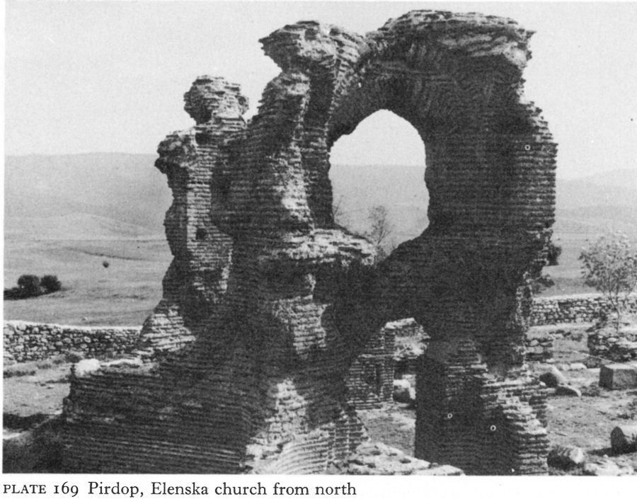
Plate 169 Pirdop, Elenska church from north
![]()
281
inside they project some 35 centimetres below floor level in the form of arcs quite unrelated to the walls. This berm continues, still irregularly, inside the walls of the sanctuary (Fig. 78).
Two massive piers, beginning 2 metres from the central apse, create a triple sanctuary, linked by arched openings, and also form the eastern supports of a central dome. The corresponding western piers, built of large sandstone blocks, are half-way down the colonnades between nave and aisles.
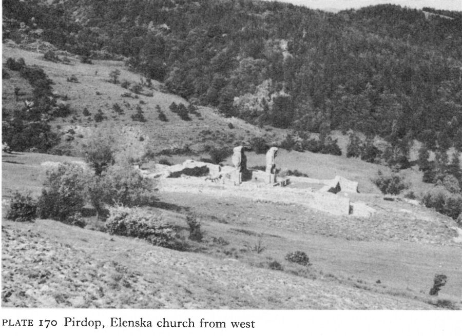
Plate 170 Pirdop, Elenska church from west
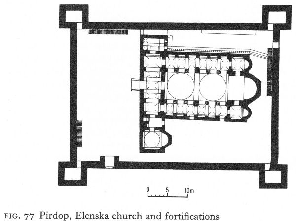
Fig. 77 Pirdop, Elenska church and fortifications
![]()
282
Fig. 78 Pirdop, two building phases of the Elenska church
There are two brick piers at the western end, but it is debatable whether this half of the nave was domed or barrel-vaulted. The narthex, divided by pilasters suggesting arches corresponding to the colonnades, was half a metre wider at the north end than at the southern. A north annex contained a spiral staircase and a southern, a small rectangular room - also with stairs - had an entrance to a square apsed chamber, perhaps once a baptistery, although with no trace of a piscina. The existence of galleries above the narthex and aisles, implied by the stairs and general solid construction, is confirmed by the remains of brick vaulting at the east end (Pl. 171).
The two building phases are easily distinguishable. One consists of opus mixtum - broken stone and mortar with a bonding layer of three brick courses, the other entirely of carefully laid brick. At a point in the south wall - probably originally a doorway - the dividing-line is very clear. Of the existing structure, the east end, with its piers, the wall between nave and narthex, and the north annex are brick-built. The rest of the walls and the south annex are in opus mixtum (Fig. 78). The brick pilasters against the inner face of the north and south walls, but not constructionally linked, must be later additions. As their materials and construction techniques are identical with the wholly brick-built
![]()
283
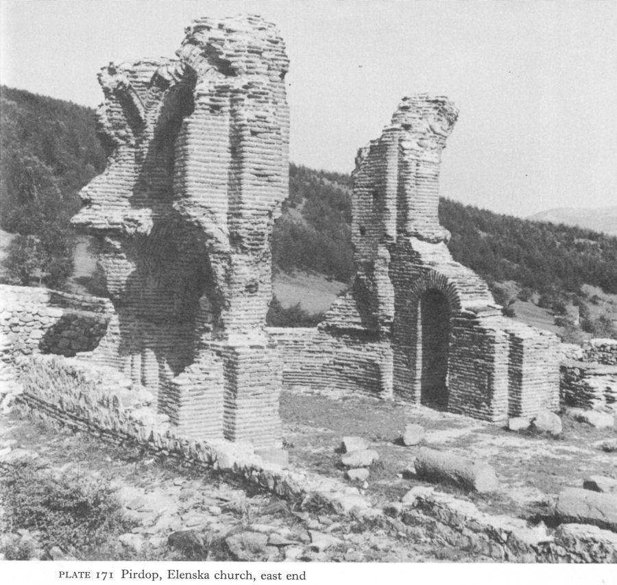
Plate 171 Pirdop, Elenska church, east end
eastern parts of the church, the opus mixtum clearly represents the first building phase and the brick the second.
There had originally been plain monolithic columns, standing on stylobates. In situ were two columns of mortared sandstone drums, no doubt re-used fragments. In this provincial context, the few remains of decorative carving could belong to either the fifth or the early sixth century. Mutafchiev dated the earlier phase to the second half of the fifth or the early sixth century, and the later to the reign of Justinian. The sanctuary’s resemblance to that of the Episcopal Church at Caričin Grad [5] supports the latter dating; the earlier is more open to question.
The surrounding walls have lent superficial support to the monastic legend, but the angle towers and the 1.60-1.70-metre-thick walls with ramparts are purely defensive. Judging by surviving steps, the height varied from 5.30 to 10 metres, according to the terrain. No trace of other building was found within the walls, nor was there much space available.
![]()
284
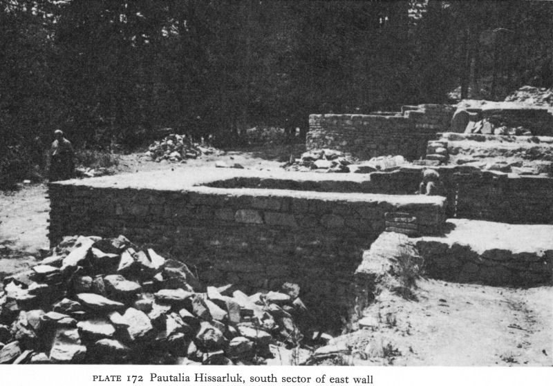
Plate 172 Pautalia Hissarluk, south sector of east wall
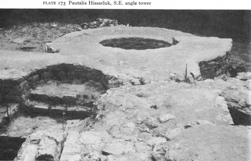
Plate 173 Pautalia Hissarluk, S.E. angle tower
![]()
285
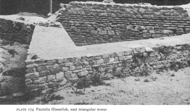
Plate 174 Pautalia Hissarluk, east triangular tower
But the church itself could provide a local refuge during a raid, and there was room enough outside it for livestock. The main entrance, a double gateway, was in the south wall, protected by the south-west tower. A smaller gate, probably a postern, near the north-east tower, led down a steep slope to the stream.
II. PAUTALIA AND THE SOUTH-WEST
When Dacia Mediterranea was created, Pautalia ranked after Serdica and Naissus as the third city of the province. Julian repaired the fortifications, but the west gate was first narrowed to a postern and later blocked up entirely. In 479, Zeno offered the Pautalia region to Theodoric the Amal and his Ostrogothic followers. It is possible that the territory had escaped the Hun invasions and Malchus of Philadelphia quotes the imperial envoy’s description of ‘abundance of land beside that which was already inhabited, a fair and fertile territory lacking cultivators, which his people could till, so providing themselves with all the necessities of life’. [6] Theodoric, with reason suspicious of Zeno’s motives, declined the offer.
Current excavations, including a large three-naved single-apsed Christian basilica with a fine mosaic floor, [7] show the city’s continuing existence in the fifth century. Procopius speaks of repairs to the walls, stating that, like those of Serdica, Naissus, and Germania, they had fallen into disrepair, but he may not have been referring to the city in the plain, the modern Kyustendil, for a new fortress had been built some 150 metres above it, on the summit of the Hissarluk.
Unlike those on the Danube limes, the citizens of Pautalia had only to climb to their Hissarluk for refuge. Its flat summit, the shape of a truncated arc roughly 250 metres long, was joined by a narrow saddle to the main Osogovska massif. The walls of the fortress - a deep re-entrant on the east, a long convex curve on
![]()
286
the west overlooking the city - were reinforced at the four corners by external round towers. No others were needed to defend the precipitous north, west, and south slopes, but two rectangular external towers strengthened the more exposed east wall, which, incorporating two double gateways, was up to 2 1/2 metres thick, compared with an average of 1 1/2 metres on the north side, which had only a postern. [8] The most vulnerable point, the south-east corner, had, in addition to its round angle tower, an eastern rectangular one with a postern between them (Pls. 172, 173). Protecting the south side and a conduit bringing water into the fortress were two substantial triangular towers only 8 1/2 metres apart, the nearest but 2 1/2 metres from the round tower (Pl. 174). It appears that a semi-projecting square tower later replaced the triangular one next to the angle (Fig. 79).
Partly on grounds of the building techniques, notably comparisons with Theodosian walls at Thessalonica, and partly because of 22 fourth-century coins (the reigns are not stated) and 14 small coins of the second and third centuries found in the foundations, I. Ivanov dated the walls to the fourth century, considering them a part of Julian’s defence programme for Illyricum. However, the recently re-excavated south-east angle with the triangular towers must be fifthor sixth-century work.
Current conservation work has mainly concentrated on the important southeast corner. During the 1906-12 excavations, walls of what were probably barracks or stores were traced by the east wall. On the west side, where the present Hissarluk hotel stands, part of what were thought to be baths were found. South of this, overlooking the city below, on the magnificent site earlier occupied by the pagan temple (Pl. 115), are the fragmentary remains of a large three-naved single-apsed basilical church, probably of the fifth or sixth century.
Pernik and Germania
The disastrous Visigothic invasions led to a temporary revival in the fortunes of the middle Struma valley, the speediest route from Macedonia for reinforcements to the Thracian plain, the Dacias, and the lower Danube.
![]()
287
The Krakra stronghold above Pernik continued to be inhabited, which is hardly surprising in view of its almost impregnable position above the Struma. Coins continue until those of Justin II, when there is a gap - no doubt filled by Slavo-Bulgar occupation - until the end of the first Bulgarian state.
Germania was the birthplace of Justinian’s great general, Belisarius. Procopius states that Justinian rebuilt its fortifications and a sixth-century wall has recently been identified.
Sandanski
Confirmation that Sandanski shared this brief, strategically motivated prosperity comes, paradoxically, not from military monuments but from the excavation of four churches, three with mosaic floors, and one large baptistery. The last was found by soldiers in 1917; the churches are new discoveries and only one has been published, although a second, three-naved, has been provisionally dated to the fourth century.
Only part of the baptistery, probably attached to an episcopal church, was found (Fig. 80). Inside a circular outer wall, it seems that an ambulatory enclosed another wall in which remained evidence of two shallow niches flanking a doorway, itself enclosed within a wider and yet shallower niche, leading to an octagonal piscina. Here and opposite the doorway three steps led down to the marble floor of the pool. Fragments of slender marble columns, decorated at the top with stripes of red and gold paint, probably surmounted pilasters round the pool to support a ciborium or ornamental canopy. The niches of the inner wall were painted in geometric patterns. Other architectural fragments included a marble column 2 metres long, Ionic impost capitals carved with crosses, birds, ivy and acanthus leaves, and a few small remnants of wall mosaic.
A hundred metres away, in a church now partly preserved within a new museum, a mosaic inscription names a bishop, although not the still unidentified see.
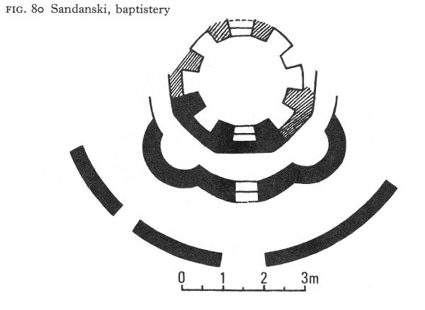
Fig. 80 Sandanski, baptistery
![]()
288
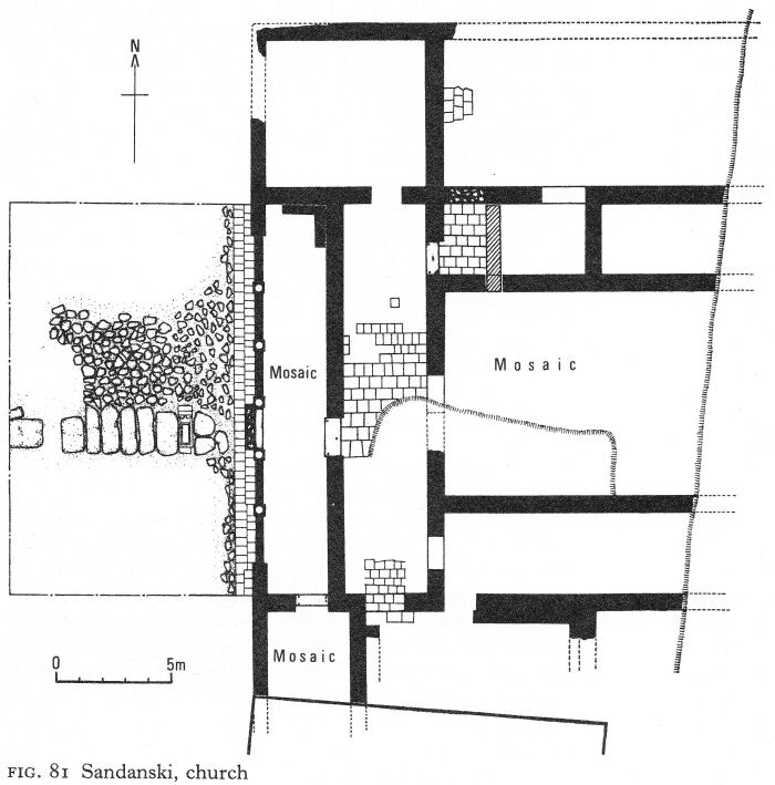
Fig. 81 Sandanski, church
The existence of this building, a three-naved basilica with narthex, exonarthex (or outer vestibule), and various annexes (Fig. 81), was detected by an alert local history-master during the course of building operations, and work was stopped to allow excavation and conservation. Unfortunately, the eastern half - probably long destroyed - lay under a main road.
The basilica stood on earlier buildings in use until about the middle of the fifth century. In the western part of the dig an open courtyard, possibly an atrium was found, but could not be fully uncovered. A path of granite slabs, including the funerary stele of M. Herennius Rufus (p. 184), crossed the middle of the courtyard to a colonnaded exonarthex, one intact column showing it to have been 2.40 metres high.
The whole exonarthex floor was mosaic, laid in geometric patterns and using a variety of colours. Facing the entrance a meander border framed the Greek inscription (Pl. 175) which may be roughly translated as follows:
![]()
289
+ You desire to know who built this splendid edifice which delights the eye with its beauty. It is John, that wise and humble man who came to take care of the episcopal seat and having as his predecessor the devout man named O . . . . .
The rest of the inscription is lost and Bishop O . . . who, John’s expression of humility notwithstanding, may actually have been the founder of the church, remains known only by his initial. On either side of the inscription are identical geometrical patterns consisting of a series of octagons linked by a meander motif and containing a white quatrefoil inscribed in a dark square, the dark areas forming a ‘Maltese’ cross.
A single entrance led to a brick-paved narthex, with three entrances to the nave and aisles, which were probably separated by colonnades on stylobates. The nave floor was also of mosaic, mostly geometrical in design but incorporating realistic birds, fishes, flowers, and ivy leaves. North and south rooms were attached to each narthex. The southern extended for an unknown distance below the present post office and possessed a mosaic floor resembling the geometric pattern of the exonarthex, but with a border of stylised lotus flowers and fish or birds in the octagons.
Very little sculptural decoration was found, with the interesting exception of fragments of three marble altar tables. One, with an unidentifiable scene carved in low relief, was round; the other two were of the ‘sigma’ type, one plain with a Latin cross in the centre, the other of the type with 12 rounded divisions.
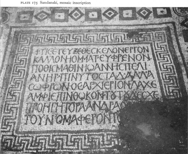
Plate 175 Sandanski, mosaic inscription
![]()
290
The excavator compares the plan of the basilica with that of Suvodol in western Macedonia, ascribed to the mid-sixth century, and there are resemblances between the mosaics and those in the Episcopal Church at Caričin Grad. For these reasons and by analogy with other churches in Bulgaria, he suggests the Sandanski basilica belongs to the first half of the sixth century, probably the beginning of Justinian’s reign. But until publication of the other churches here has established some chronology for this corner of Macedonia, dating must necessarily be tentative.
The church - and the city - were almost certainly destroyed by the Slavs late in the sixth century in some foray down the Struma to attack Thessalonica.
The Mesta Valley
As in the Roman period, little is known of Nicopolis-ad-Nestum in the Early Byzantine era. Although probably still something of a backwater, it did not entirely escape the Ostrogoths, since the Mesta route was probably used by Theodoric on his way to besiege Philippi in 473. A hoard of gold coins buried at about that time is a sign of approaching danger, but that there was gold to bury shows the relative prosperity of the region compared with others farther north.
Although Nicopolis was the seat of a bishopric, so far only one church has been excavated, in 1903, on a site locally known as the monastery of St Nedelya. A mosaic floor with decorative vegetal motifs was found. A ‘double wall’ was said to enclose the church, about which no other information is available.
Much more recently, a preliminary survey [9] of a single-apsed church, 23 metres long and 14 metres wide, was made at a site called ‘the monastery of St George’ near Debren, some 10 kilometres east of Gotse Delchev on a plateau enclosed within a fold of the Rhodopes. Among the finds were fragments of oval marble columns, marble slabs, profiled cornices, and oval impost capitals decorated with volutes and crosses, one having an alpha and omega beneath the arms of an inscribed cross. These last were dated tentatively between the fifth and seventh centuries, but it is thought that the church, with the surrounding settlement, continued to exist throughout the medieval period until its conversion to a mosque, which eventually fell into ruins. Columns were removed to be built into fountains in Debren, but the abandoned site retained what is believed to have been its earlier name, ‘the monastery of St George’.
NOTES
1. Stancheva, M., Serdika I, 1964, 159 ff.
2. Katsarov, G. and Tachev, H., IBADI, 1910, 23 ff.
3. Hoddinott, R. F., Early Byzantine Churches in Macedonia and Southern Serbia, London, 1963, 211-13.
4. Boyadjiev, S., Izsled Dechev, 1958, 611 ff.
5. Hoddinott, op. cit., 206-9.
6. Quoted Hodgkin, T., Theodoric the Goth, London, 1891, 86.
7. NAC 1970, Arh XII/3, 1970, 79.
8. Gocheva points out that the orientation shown on the Hissarluk plan published in IB AD VII, Fig. 66, is incorrect for ‘north’ read ‘west’.
9. Mihailov, S., Rodopski Sbornik II, 1969, 169-72.
13 The Thracian Plain (II)
I. PHILIPPOPOLIS
During the Visigothic wars, Valens’ strong control over Philippopolis ensured for the city and its environs a higher degree of immunity than was the case in the rest of Thracia. Not until the Hun invasion of 441-42 was it endangered, but then the damage seems to have been severe. No details are known, but substantial repairs were needed to the outer wall and to the Trimontium fortress. During the Ostrogothic wars the city was again under heavy attack. In the sixth century Procopius designates it as one of the especially vulnerable centres requiring refortification.
Except on the south side, the original walls, which were surrounded by a ditch, seem to have been repaired or rebuilt to a thickness of up to 3 metres on their old foundations. On the south the wall was drastically retracted to a new position that almost halved the size of the enclosed area, reducing the walled circuit from about 3! kilometres to a little over 2 1/2 kilometres.
Remains of one of the inner fortress gates, the ‘Hissarkapiya’, built in the late fifth or early sixth century, still stand today near the church of SS Constantine and Helena. The gate, now impinged upon by neighbouring buildings, is in the east wall between Djambaz-tepe and Nebet-tepe. It was probably flanked by two square towers, the size of which could not be ascertained. The site of one is occupied by the present Ethnographical Museum and the other by the east end of the church, beneath which was found an entrance to the tower from inside the fortress. In the vicinity of this gate, the curtain wall - of opus mixtum with bands of five brick courses - has been preserved to a height of over 4 metres. It incorporated an externally projecting round brick tower, the lower parts of which survive.
Walls have also been uncovered on the south slopes of Djambaz-tepe and the north-west slopes of Nebet-tepe. They vary in height from 2 to 8 metres and were often built upon Roman and Hellenistic substructures (Pl. 176). From a gate in the north wall of Nebet-tepe a flight of steps, 16 of which remain, descended the steep slope to the outer wall.
These measures enabled at least the inner fortress to survive Avar and Slav attacks and to remain in Byzantine hands until its absorption into the first Bulgarian state. Anna Comnena visited it in the first half of the twelfth century. ‘Once upon a time’, she wrote, ‘Philippopolis must have been a large and beautiful city . . . equipped with an enormous hippodrome and other buildings of note. I myself saw traces of them.’ [1]
The fourth-century baths near the foot of Djambaz-tepe were destroyed in the fifth century, probably by the Huns, and rebuilt on a more modest scale. A room from the lower floor, with opus mixtum walls, had four cross-groined vaults, each with three ventilation holes, supported on nine massive brick piers (Pl. 177). This room had originally had hypocausts; in the second phase it was probably part of a heating system using hot water. Avars or Slavs finally destroyed these baths about the end of the sixth century.
![]()
291
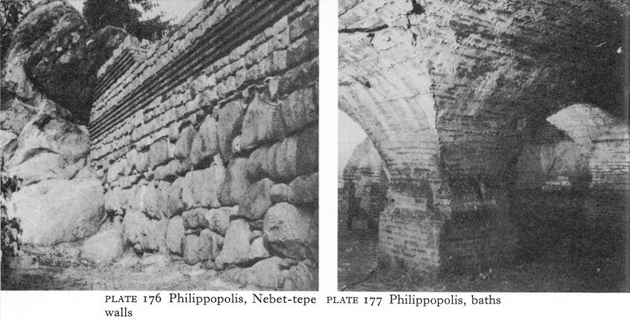
Plate 176 Philippopolis, Nebet-tepe walls
Plate 177 Phiiippopolis, baths
By the end of the fourth or early fifth century, a temple to the new imperial religion of Christianity had replaced the shrine of Apollo on Djendem-tepe, recalling the similar transformation at Pautalia. This was a three-naved, single-apsed basilica with a narthex, 35 metres long and 19! metres wide; it was buttressed by opus mixtum walls on the sloping sides of the hill. A wide apse and relatively wide nave and narrow side-aisles are evidence of an early date. The erection of a church in this situation must have been a symbol of triumph, seized by the Christians as soon as the religious climate made it possible, probably after Theodosius’ Edict of 380 had enabled the Christian hierarchy to take over the pagan shrines.
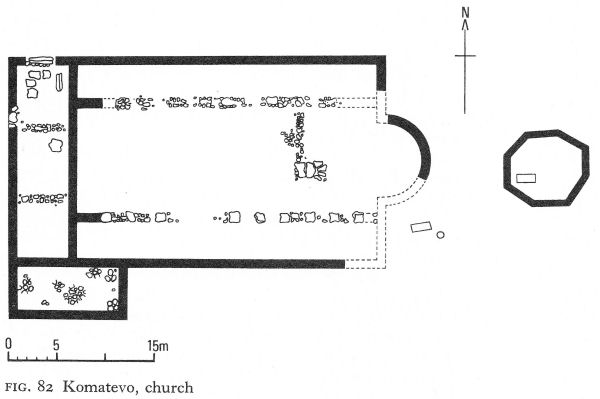
Fig. 82 Komatevo, church
![]()
293
The foundations of an unusually large - probably fifth-century - Christian basilica have been excavated at Komatevo, originally a Thracian settlement 7 kilometres south of Plovdiv. Single-apsed, three-naved, and with a narthex, it had an overall length of 43 1/2 metres (Fig. 82). The width of the nave was almost three times that of the aisles. A rectangular annex on the south-west may have been a baptistery, although no trace of a piscina was found. An octagonal structure had stood 8 metres east of the apse; its plain brick floor covered two Christian graves. The well-cut stone blocks of some earlier building on the site had been used in the church. The size of the basilica may simply be due to its serving a populous area; the remains of small, flimsy two-roomed houses were found, densely packed, in the neighbourhood.
II. PEROUSHTITSA
At Peroushtitsa substantial ruins of a sixth-century church built on an unusually interesting plan stand alone against a background of the Rhodope foothills, an impressive memorial of the prosperity of the Early Byzantine settlement (Pl. 178). Two brick piers on the north side of the church are still nearly 14 metres high; between them an intact arch spans 5 1/2 metres and curves up to 11 1/2 metres above the floor (Pl. 179). Even traces of wall painting are still discernible.
The Red Church - so called from its exceptionally fine all-brick construction, the only stonework being later repairs - was the second church on the site (Fig. 83). Little remains of the first, for there is only a thin layer of soil over solid rock, obviating both need and possibility of deep foundations. From the west, a central entrance in a portico led into an exonarthex and then by a corresponding doorway into a narthex of the same size.
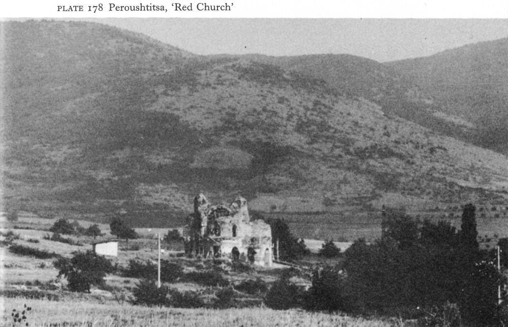
Plate 178 Peroushtitsa, ‘Red Church’
![]()
294
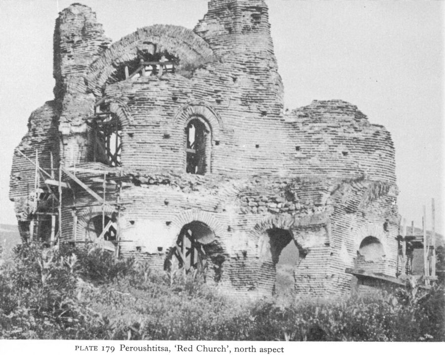
Plate 179 Peroushtitsa, ‘Red Church’, north aspect
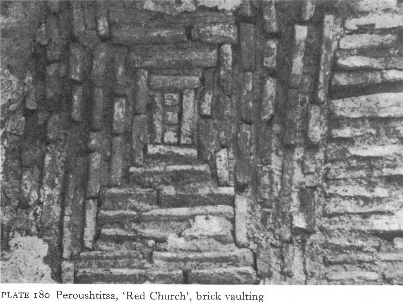
Plate 180 Peroushtitsa, ‘Red Church’, brick vaulting
![]()
295
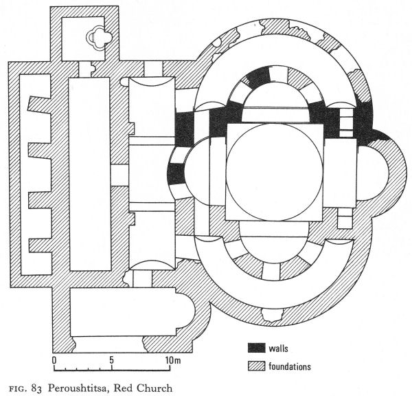
Fig. 83 Peroushtitsa, Red Church
A square baptistery with a quatrefoil piscina was reached from the north end of the exonarthex, while the south end of the narthex opened into a rectangular apsed annex.
The main part of the church, for all its centralised appearance, was essentially based on a modified basilical plan. Four great piers connected by arches enclosed a central space 8 metres square with apsidal extensions making it a tetraconch, the floor of which was probably laid with mosaic. In the north and south walls, three arched openings, formed by two freestanding piers and the end pilasters, connected this tetraconchal nave with encircling single-storied north and south aisles. The eastern apse of the tetraconch was set further back than the rest so that a barrel-vaulted choir 2.80 metres deep replaced the arched openings of the other three. Its outside curve projected as part of the outer wall of the church. On either side of the choir were two small rooms, walled off from the aisles.
Fundamentally, therefore, the Red Church can be considered as a basilica with a tetraconchal nave, two aisles, a single apse, two small presbyteries apparently serving as prothesis and diaconicon, a narthex and exonarthex.
![]()
296
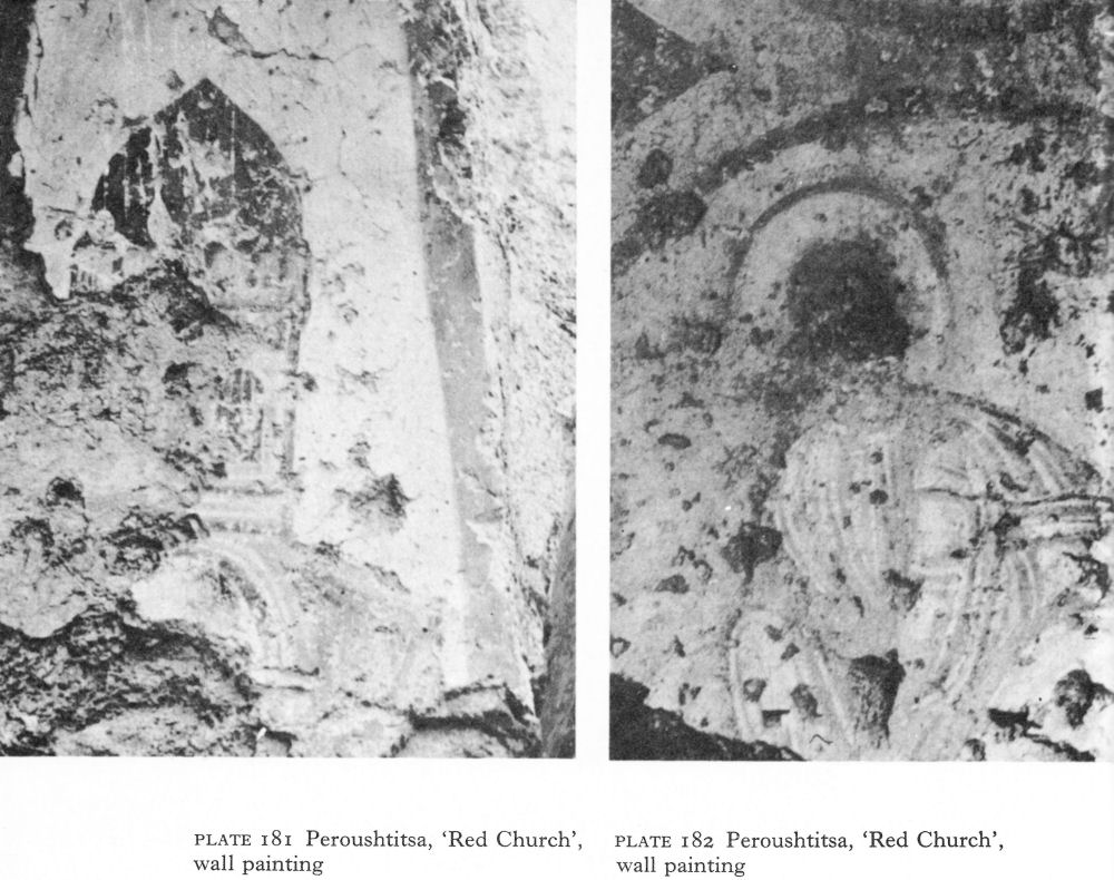
Plate 181 Peroushtitsa, ‘Red Church’, wall painting
Plate 182 Peroushtitsa, ‘Red Church’, wall painting
To this was added a baptistery and a second side-chamber or presbytery which, in view of the relatively small sanctuary, was probably a service room for the priests and deacons and perhaps also a sacristy. The central area of the tetraconch was domed, with supporting half-domes over the apses. The narthex and exonarthex appear to have been barrel-vaulted.
The unusual form has given rise to widely varying theories about date and origin. The association of the tetraconch form of nave with martyria may have been a factor, but perhaps of greater account is the evident attempt to cope with the transition from the basilical to the centralised plan in accordance with contemporary trends in Constantinople. The attempt was, in fact, remarkably successful; only the single apse coupled with the rudimentary prothesis and diaconicon rooms suggest the earlier half of the sixth century rather than the later or even, as has been proposed, the seventh. A very similar plan occurred in a now destroyed church at Hadrianopolis, and another, but with the Western form of sanctuary, in the recently excavated tetraconchal church at Ohrid. [2] Analogies are also to be found in the church in the Stoa of Hadrian in Athens and at Resafa in Syria.
Wall paintings of both the sixth and the thirteenth or fourteenth centuries have suffered severely from exposure. Plate 181, taken in 1964, shows what may have been a representation of the church itself. In the 1920s, five main groups of
![]()
297
sixth-seventh-century paintings were identified : [3] on a soffit of the prothesis two angels holding a medallion in which was the Mystic Lamb; on the wall of the north apse three rows of scenes, including the Adoration of the Magi, the Flight into Egypt, and apocryphal subjects; on the vault of the north aisle a scene of martyrdom; on the soffits of the arches between the nave and north aisle three medallions including one showing Moses unfastening his sandal before climbing Mount Horeb (Pl. 182) and another of him receiving the Law; elsewhere on these arches were angels in medallions and scenes which include the fragment of the high domed church.
III. ISPERIHOVO
At Isperihovo, nearly 20 kilometres south of Pazardjik in the Rhodope foothills, an Early Byzantine monastery (Fig. 84) incorporated a small single-naved church with a horseshoe-shaped apse and a deep narthex built of broken stone and red mortar. A contemporary baptistery was annexed on the south, but a north-west annex containing a font was a later addition, following the introduction of infant baptism (p. 325).
The rest of the complex consisted of a series of later rooms, some roughly mortared with mud; they included a cattle shed, a bread oven, and so on. Tools for woodwork and agriculture as well as household pots show that soon after the church was built a group of monks must have settled here and cultivated the land. The complex was not entirely excavated and it is possible that by the sixth century it was surrounded by a wall, of which one entrance led into the narthex of the church and a second into the farm buildings.
It is rare to find monasteries in Bulgaria at all during this period; the two baptisteries and the plan of the sanctuary suggest that the church should be dated to the end of the fourth or the beginning of the fifth century. The horseshoe-shaped apse is usually a sign of Anatolian influence.
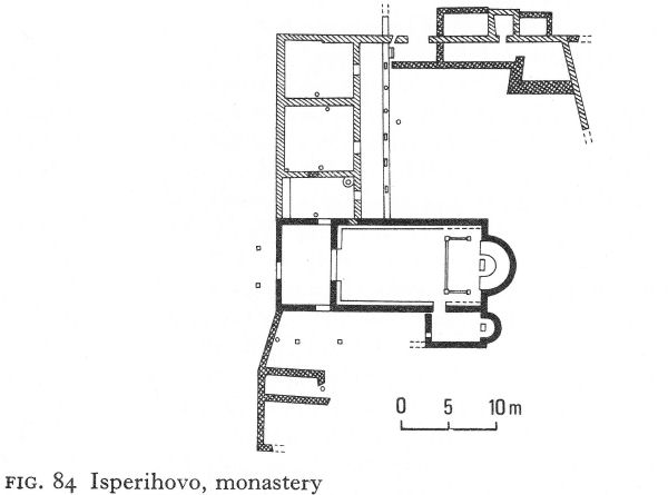
Fig. 84 Isperihovo, monastery
![]()
298
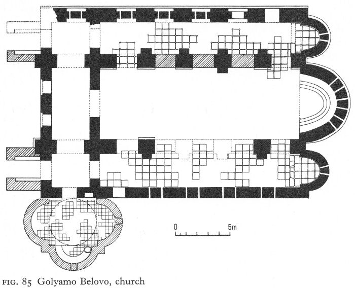
Fig. 85 Golyamo Belovo, church
IV. GOLYAMO BELOVO
Golyamo Belovo is high on a mountain terrace above the western edge of the Thracian plain, 26 kilometres west of Pazardjik. Here the substantial remains - reaching a height of over 7 metres - of an Early Byzantine brick church excavated in the 1920s were recently re-examined. Some of the apparent inconsistencies are now thought to be due to changes of plan made during construction; others occurred later when the building was partly reconstructed.
The church was a three-naved basilica built on bedrock foundations, with three ovoid apses and a narthex (Fig. 85). The central apse was lined with a three-stepped synthronon and parts of what appear to be the base of a sanctuary screen were found in situ at the openings of the side-apses, so these latter presumably served as the prothesis and diaconicon. Unusual differences were noted between the north and south outer walls. The former, in effect, consisted of a series of substantial piers, between which narrower sections enclosed large windows and, at the eastern end, a doorway. The southern wall was normally constructed, with a doorway in the western end and four evenly spaced windows.
Four brick piers of the same thickness as those of the north wall separated the nave from the aisles. Although not symmetrical either with the piers of the north wall or with the windowless parts of the south wall, they supported cross-groined vaulting over the aisles. The roofing of the nave is disputed. While the remaining six piers have pilasters on their outer faces, only one has a pilaster projecting into the nave. The opposite pier has not survived, but a dome could not have been supported by the relatively weak piers and walls of the apses.
![]()
299
A. Grabar and W. Emerson suggested a barrel vault. After re-examination, S. Boyadjiev detected signs that all the piers originally had inner pilasters, so proposed that the nave, too, had a cross-groined vault.
The trefoil-shaped baptistery, it is now pointed out, was certainly added later. It is also likely that the narthex had no upper storey, as at first thought, but was flanked by two towers. But the proposed siting of the towers as north and south projections of the narthex, rather than above the aisle divisions, is less convincing on the evidence adduced, although it is a common contemporary feature in the central Balkan area. The first phase of the church may have been begun in the late fifth century, but the structure of which part is standing today essentially belongs to the sixth.
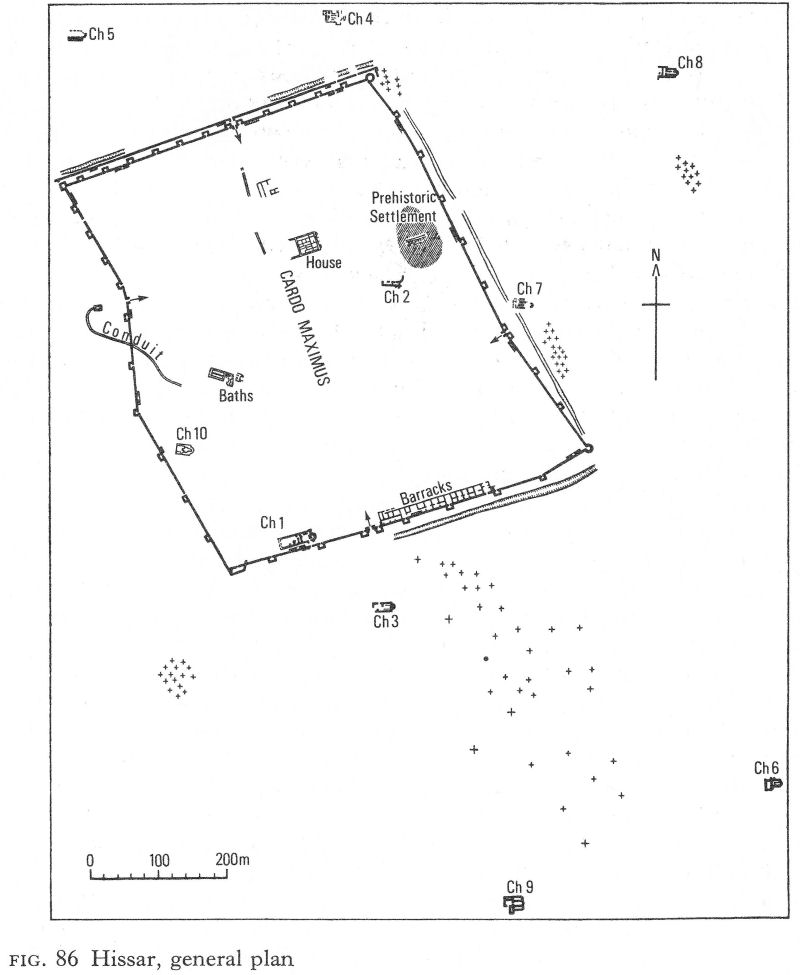
Fig. 86 Hissar, general plan
![]()
300
Golyamo Belovo is only one of several churches, as well as fortresses, built in this part of the Rhodopes during the fifth and sixth centuries. Around Velingrad others have been found at Barata, Beglichka, Rangela, and Rakitovo, [4] and the church at the Tsepina fortress was originally constructed in this period. In spite of the mountainous terrain, it was then a populous area and controlled the strategic routes linking the Thracian plain with the Mesta and Struma valleys.
V. HISSAR
The fourth-century prosperity of Hissar continued, in spite of destruction by the Visigoths - and probably some damage by passing Huns and Ostrogoths - at least to the turn of the sixth and seventh centuries, when Solomon, vicar of Thracia in the reign of Maurice, is recorded as having died there while taking the waters. Even today the surviving walls are a testimony of successful resistance to the Avars - a point in favour of identification with Diocletianopolis, which is said to have fought them off in 587 with the help of strong fortifications. Soundings in the town and pottery finds indicate that Hissar probably came to terms with the surrounding Slavs during the seventh century. It later became a Bulgarian strongpoint in the Thracian plain, thus accounting for a burning layer associated with coins of John Tzimisces, who conquered much of the first Bulgarian state in the late tenth century. Thereafter Hissar appears to have lost its strategic importance and, far enough from the main roads to avoid the march of progress, it continued as a small watering-place in a land abounding with them. It has thus preserved an important archaeological heritage.
The impressive curtain wall (Fig. 86), long stretches of which have been conserved and are visible today to a height of nearly 12 metres, was in opus mixtum with bonding layers of, usually, four courses of brick and between 2 1/2 and 3 metres thick. The quality of materials and high standard of workmanship have been important factors in its survival. The stone facing - of granite and gneiss from nearby quarries - was laid in bands of approximately 1 metre, the outer surface being carefully smoothed, the fill being rubble and mortar. The bricks were well fired and the mortar extremely hard (Pl. 183).
At least 11 double staircases led to the rampart walk; now from 14 to 18 metres wide at the base they were originally slightly larger. Under the arches of two in the inner north wall, small posterns gave access to the outer defences. Five single staircases have also been found. Brick-vaulted channels pierced the wall to expel surplus rainwater.
So far 43 contemporary towers have been located, 12 being on the inner north wall, ten on the west, eight on the south, nine on the east, and four angle towers. All projected and, except for the rounded north-east and south-east angle towers, all were quadrangular. With inner dimensions of about 5 by 5.30 metres, they were probably at least two-storeyed; recesses being visible in some of them for beams to carry a second floor 4.2 metres above the berm. The earlier towers were generally similar, but some did not project so far. Analogies have been drawn with the towers of the east wall at Novae.
The eastern angle towers were planned to withstand battering rams. The south-east one was fan-shaped, as at Abritus and Voivoda. The north-east angle tower is quite different - an irregular octagon built on rounded foundations (Fig. 87).
![]()
301
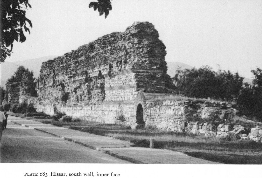
Plate 183 Hissar, south wall, inner face
There are two floor levels, one 40 centimetres above the other, with traces of burning between. The round foundation may have been earlier - it was of opus mixtum with one remaining bonding layer of five courses of brick - or else a special base because of the tower’s site on the steep bank of a stream. In the final building phase, the entrance, previously apparently open, was given grooves for a door, perhaps in case of a breach in the curtain wall.
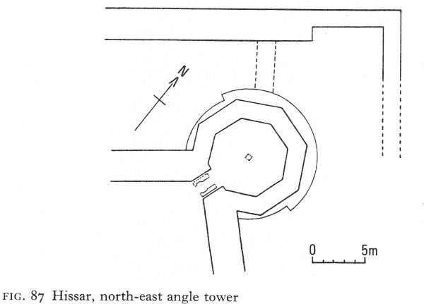
Fig. 87 Hissar, north-east angle tower
![]()
302
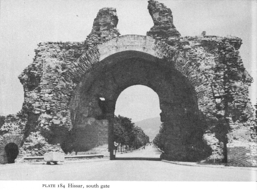
Plate 184 Hissar, south gate
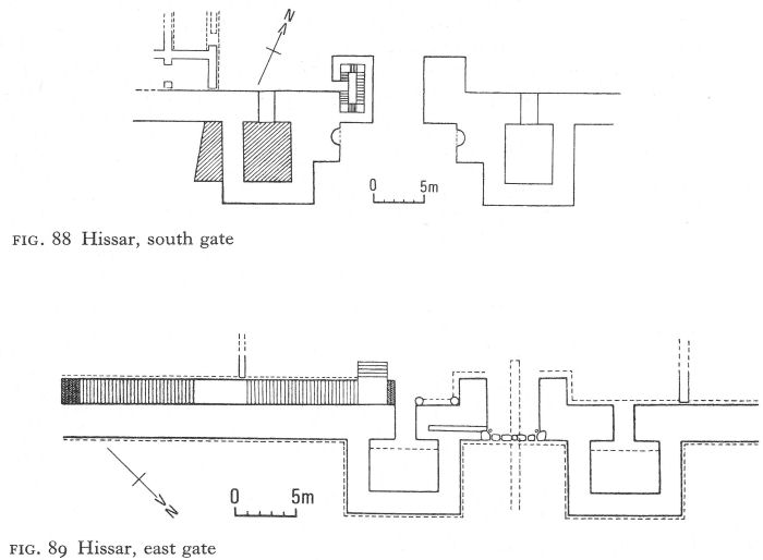
Fig. 88 Hissar, south gate
Fig. 89 Hissar, east gate
![]()
303
A gate was more or less centrally situated in each wall. The main gate (popularly called 'The Camels’) in the south wall met the road from Philippopolis and had a ceremonial as well as a defensive purpose; it probably replaced a simpler one. It stands 14 1/2 metres high today, an impressive monument in regular use (Pl. 184, Fig. 88), which has acquired the inevitable legend that someone was walled up alive to keep it from collapse. Here a craftsman’s wife leading a child is said to have been chosen. She had tucked a sprig of rue into her headscarf and the child was playing with a nut. In the early 1900s the legend was locally claimed to be proven because nut trees and rue, growing high up in the ruin, were always visible and always green.
The ceremonial gateway, projecting beyond the curtain wall and flanked by two projecting rectangular towers, consists of a great outer brick arch 11 1/2 to 12 metres wide. Erosion precludes precise measurement. Above the 12-metre high apex stand the remains of a second arched opening, 2 1/2 metres high. The walls of the lower arch contained a shallow niche on either side, perhaps for statues of emperors or gods or some other ornamental or pious purpose. The rest of the gate projected inside and was aligned with the curtain wall. Its 4-metre-thick walls enclosed a propugnaculum - nothing is left of the doorways - and obviously supported a tower, of which the upper arch formed part.
The west gate, even better preserved and also in daily use, is slightly smaller, than the south gate and without its ceremonial accretions and integrated flanking towers (Pl. 185). The outer face is an arched opening in the curtain wall, 7.90 metres high and 4.30 metres wide.
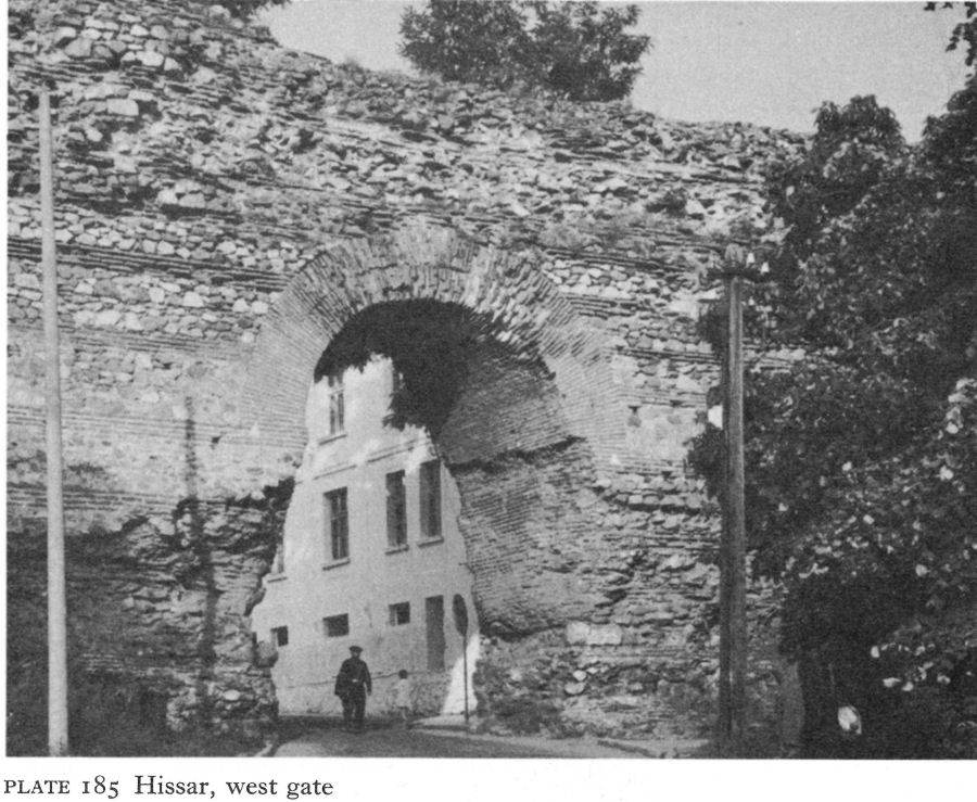
Plate 185 Hissar, west gate
![]()
304
The 5-metre-deep gateway projects inside the wall, which continues on either side of the gate and uninterruptedly above it to a preserved height of 11.60 metres.
The east gate, on the same general plan but with flanking towers, has survived only to a maximum height of 2.20 metres, but has been fully excavated (Fig. 89). The lower parts consisted of socles of large cut-stone blocks, some reused. Three floor levels were found in the entrance, the first reconstruction probably following comparatively minor fire damage, but the next after a major razing of the structure. A brick-paved drain, 1.32 metres deep and 60 to 68 centimetres wide, passed under the entrance, narrowing to 25 centimetres just under the threshold, presumably to prevent enemy infiltration. Building phases of the rectangular towers flanking the entrance corresponded to those of the gate.
East of the south gate were three large barrack-like buildings, terminating in a colonnade; finds suggest the rooms included a kitchen, and a store-room with many lower parts of dolia. Other similar buildings were annexed west of the same gate. These were dismantled and replaced by a church, an operation which provides the main evidence for the date of the walls.
Comparatively little of the double north wall now remains above ground (Pl. 186). The inner wall had towers, posterns, and staircases like the others; its gate faced one in the outer wall, which was a separate structure, 3.2 metres wide. Also built in opus mixtum, the stone, from another quarry, was friable compared with that used in the main walls. The construction of its three single staircases was also inferior. The wall extended several metres west of the inner wall, ending in a buttress which also protected a postern linking the two walls.
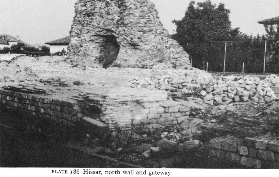
Plate 186 Hissar, north wall and gateway
![]()
305
There had been heavy destruction at the eastern end.
The only epigraphic evidence on the fortifications is provided by two dedicatory inscriptions of the reign of Alexander Severus re-used in the facing of the west wall. The main clue to the date of construction is provided by the church known as no. 1. Originally thought to have been fifth- or sixth-century, new thinking assigns the walls to the late fourth or beginning of the fifth century, that is, after Visigothic destruction of the earlier fortifications. The various building phases may be explained by the growing number of attacks in the Early Byzantine period. Pending fuller excavation - difficult in a popular health and holiday resort - this conclusion, generally agreed by archaeologists concerned in recent excavations at Hissar, seems reasonable.
Hissar is also archaeologically important for the number of Early Byzantine churches excavated in and around the town. Unlike the walls, most are no longer visible, and in any case little more than foundations remained, uncovered at different periods over the last 75 years. Their number, counting superimposed churches, totals 11, excluding two in the nearby village of Sindjirli, by no means an extraordinary total for what was almost certainly an episcopal centre in that age of church building and of barbarian destruction; their significance lies in being a group based on a single town, so that even though dates must be tentative, it is possible to trace some kind of chronological evolution in a small area. The churches are numbered in scientific literature according to their order of discovery - a convention followed here and in the plan of the town (Fig. 86).
The approximate order of construction here suggested in general agrees with the dates proposed by the excavators - although a major qualification must be the unscientific nature of some of the early excavations. Nevertheless, it illustrates the architectural response to the evolution of the liturgy, with local ritual requirements - or idiosyncrasies - also playing a part, as did the nature of the terrain. What churches existed together at any given time is impossible to say; demolition was not always due to enemy action. Two demonstrably replaced predecessors, but other replacements were not necessarily erected on old sites. The introduction of the three-sided apse is usually deemed to follow the construction of St John Studios in Constantinople in 463, but, owing to population movements, regional developments and fashions often spread faster in the provinces than in the more conservative capital. The same considerations apply to the introduction of the tripartite narthex and to the subsequent appearance of the tripartite sanctuary - in Constantinople in the reign of Justin II.
Two churches were probably built very soon after the Visigothic war. Church 3A, 100 metres south of the south gate, provided the plan and foundations for church 3B, which, in fact, was probably the simple restoration of a badly damaged building with the substitution of a more ‘modern’ three-sided apse for the earlier rounded structure (Fig. 90). Church 3A was three-naved with a narthex and an atrium, the nave being precisely three times the width of the aisles. At the east end of the north aisle steps led up to a doorway. The much-destroyed narthex appears to have had no internal division. A flimsy wall, leaving an ambulatory about a metre wide inside the apse, was probably the synthronon of church 3A.
Church 4A (Fig. 91), about a hundred metres north-west of the north-east
![]()
306
angle tower, was built on an earlier structure, perhaps a pagan shrine. The church was three-naved, with a disproportionately large and accentuated horse-shoe-shaped apse, 6 metres wide at the chord and 3 1/2 metres deep; a similar flimsy concentric wall or synthronon provided an ambulatory. The stylobates of the nave, each bearing five columns, turned outwards at a right-angle a metre from the east wall and continued parallel to it almost to the side-walls. About a metre from the west end, north and south projections from the stylobates formed a kind of narthex. Two small semicircular walls projecting from the stylobates by the westernmost pillars may have held receptacles for offerings.
There are three other three-naved basilicas with single semicircular apses and undivided narthices. These are no. 2, inside the walls, no. 5 about 200 metres north of the north-west angle tower, and no. 8 at Momina Banya.
Church 2 was relatively large, over 34 metres long and about 24 metres wide. Only the foundations of the south half remained, but it could be seen that the nave was about double the width of the aisles. The south wall continued beyond the east end of the south aisle, possibly to inscribe the apse. The narthex was about 6 1/2 metres wide, about 2 metres more than the aisles. The columns of the nave were made of separate drums of local granite-gneiss.
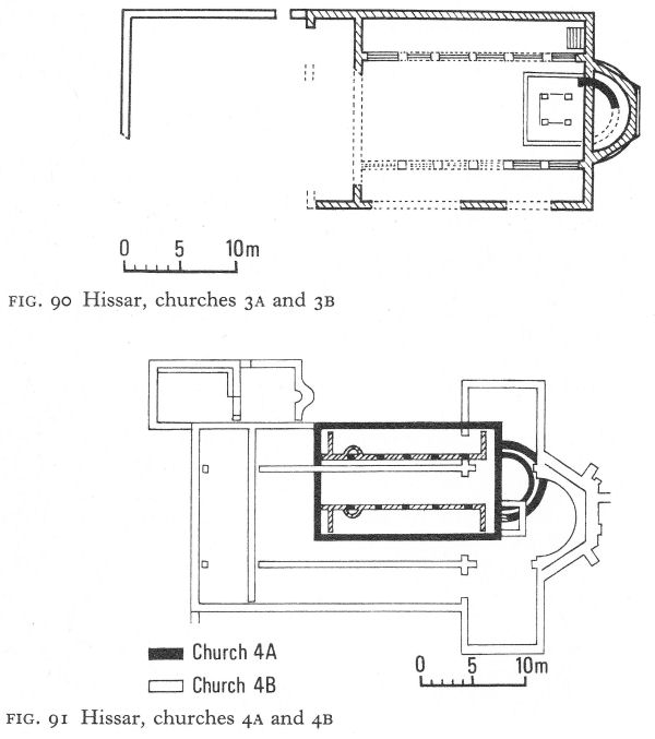
Fig. 90 Hissar, churches 3A and 3B
Fig. 91 Hissar, churches 4A and 4B
![]()
307
Fig. 92 Hissar, church 8
Church 5, similarly destroyed, was smaller, only 26 1/2 metres long. With a wide apse, the nave was nearly three times the width of the aisles, which were very slightly narrower than the narthex. Bricks laid directly on the ground formed the floor. Remains of two columns showed a construction of quarter-circle brick segments mortared together, a feature of several Hissar churches and a town house.
Church 8 (Fig. 92) at Momina Banya had a narthex, as usual slightly wider than the aisles, opening on to a western portico with two granite bases remaining in situ. Possibly here was an atrium, but a modern street prevented further exploration, As a baptistery with a shallow eastern apse and U-shaped piscina was not constructionally linked to the church, it was probably a later addition. The church itself showed signs of having twice been repaired.
These five churches must be dated to the last two decades of the fourth and first half of the fifth centuries. The likelihood that churches 3A and 4A were the earliest does not imply that the others were much later. As both were replaced by churches with three-sided apses, first seen in Bulgaria during the fifth century, the Huns or Ostrogoths may have destroyed the whole group.
Church 7, just outside the east gate, was so mutilated that even the foundations of part of the east end were untraceable (Fig. 93). Unlike the earlier group, the narthex was divided into three rooms, with communicating doorways. In the west wall, three other doorways led to the nave and aisles. Granite-gneiss bases with grooves for intercolumnar slabs stood on stylobates which carried brick pillars like those of church 5. An opening in the north stylobate about 3 1/2 metres from the east wall suggests that the eastern end of the north aisle was used as a prothesis. Unfortunately nothing more of the sanctuary survived.
![]()
308
Fig. 93 Hissar, church 7
Nevertheless, with a tripartite narthex and possibly a tripartite sanctuary, church 7 begins a new phase in the ecclesiastical architecture of Hissar. It is a question whether this church should be dated shortly before or shortly after the Hun attack.
Church 3B, already described with its predecessor, was built in the second half of the fifth century (Fig. 90), probably retaining the Π-shaped sanctuary with a marble ciborium above the altar table. Colonnades of five segmented brick pillars, plastered and painted, on stone bases, lined the nave. The stylobates ended at the second pillar from the east, suggesting a conversion to a tripartite sanctuary. A silver reliquary was found here, and a funerary slab with an inscription, probably of the fifth century, shows the church was dedicated to the ‘first martyr’, St Stephen.
Church 1, annexed inside the south wall west of the gate, was also a conversion, although its predecessor was possibly a barracks (Fig. 94). Its dating is a key factor for that of the walls. The earlier ‘barracks’ was a series of intercommunicating rooms parallel to the walls and separated from them by a corridor partly occupied by a double staircase to the rampart-walk, and a tower. North of the rooms another, slightly wider, corridor was bounded by a colonnade. Just east of the tower, a north-south passage between the ‘barracks’ and another room (or series of rooms) gave access to a postern, underneath which ran a drain.
The church, built above the foundations of these rooms and the colonnade, was two-naved, the south wall using the foundations of the south wall of the barracks, the north wall following the line of the colonnade. A new colonnade separating the nave from the north aisle inside the church did not coincide with
![]()
309
the north wall of the barracks, but was just outside it, giving the nave - some 13 1/2 metres long - a width of about 8 metres, three times that of the aisle. The three-sided apse stood above the room east of the passage to the postern; the passage itself appears to have been rebuilt as a tripartite sanctuary and the postern walled up. The west wall of the narthex made use of one of the older walls and an original doorway. Although the wall between the narthex and the nave was new, giving the former a depth of 4 metres, the nave entrance was not opposite the outer door. Another curious asymmetrical feature was a bend in the line of the new colonnade to meet the north pilaster of the apse.
The original excavator, R. Filov, considered this church a three-naved basilica partly demolished by the later construction of the walls, but a re-examination by S. Boyadjiev revealed the precise arrangement of the earlier ‘barracks’ and the fact that the southern extension of the passage to the postern overlies the socle of the curtain wall. There thus seems little doubt that the curtain walls are earlier than the church, which was always two-naved. The area between the nave and curtain wall could not have served as the south aisle, for the staircase, which occupied most of its space, was needed to provide access to the rampart-walk. One possible explanation for this strange plan is that it was built as a ‘garrison chapel’. The relationship between liturgical requirements and ecclesiastical architecture in the early Church has been insufficiently studied, but it is known that catechumens and communicants, and men and women, were separated. If at the time of building it was customary to segregate the sexes into different aisles, one aisle only would suffice for soldiers, whilst the passageway to the walled-up postern provided a ready-made site for a diaconicon.
Fig. 94 Hissar, church 1 (with tower of first building phase)
![]()
310
It is noteworthy that the two churches at Sindjirli, 4 kilometres from Hissar, are a single-naved church with a three-sided apse and a two-naved church with a rounded apse. The latter is the only other example of a two-naved church known in Bulgaria. Taking account of the new evidence, church 1 is dated soon after the middle of the fifth century. Fragments of architectural decoration do not conflict with this date.
Church 4B, although built above 4A, had little structural relationship with its predecessor (Fig. 91). A three-naved basilica with a single three-sided apse, transept, and narthex, it was about 33 metres long with a two-roomed baptistery on the north side. The apse was unusually thick-walled and also buttressed because of its site on the river bank. The narthex contained two square bases attached to its west wall and aligned with the nave colonnades, but no other trace of divisions. No entrances were preserved and no bases of the colonnade pillars were found in situ. The transept, probably separated from the nave and aisles by arched openings, formed a large tripartite sanctuary, in its centre the altar, a substantial rectangular structure open on the long west side, measuring 2.40 by 1.80 metres with walls 55 centimetres thick. A small crypt below it held a lead reliquary. Nothing else remained of the sanctuary arrangements. This church is generally dated to the latter half of the fifth or beginning of the sixth century.
Church 6 (Fig. 95), about half a kilometre south-east of the south-east angle tower, has a basic plan reminiscent of the early group of churches. It had a single semicircular apse, buttressed by a supporting wall because of the nearby river. The narthex was divided into three by arched openings, and a small square room was attached to the south end. West of it a later courtyard contained a row of partly preserved brick pillars and some re-used marble capitals. The contrast with the early group lay principally in the well-defined tripartite sanctuary, 6 metres deep compared with the 14-metre-long nave. Almost in the centre, below the probable site of the altar, a brick vaulted crypt with stone walls, 1.40 metres square and about 1.70 metres high, was approached by five steps on the east side. In the middle of its north, west, and south walls were niches, beginning just over a metre from the floor. The walls were plastered and painted, although only black rectangular frames could be distinguished. Such a deep tripartite sanctuary is unusual, but proximity to the river may have hindered the building of side-apses - buttresses supported even the straight walls - and there may consequently have been practical reasons for creating a deeper prothesis and diaconicon than usual within the body of the church. Despite its single rounded apse, a date in the sixth century seems appropriate.
Church 9 (Fig. 96), about 700 metres south-east of the south-west angle tower, stood in the middle of the largest necropolis. Remains of slim marble columns were found in its strongly developed tripartite sanctuary, and it is the only Early Byzantine church in Hissar to have three apses, all of which were semicircular. The nave is so short as to be almost square, the aisles exactly half as wide. Fragments show that the floor was paved with marble and brick in careful patterns. The narthex was also tripartite; the length of its central and northern divisions was 6 metres, nearly a metre longer than the nave; the south room was shorter but wider. The building is obviously sixth-century; in view of its situation it may have had a funerary purpose.
The discovery of the only secular building of the Early Byzantine period in Hissar was unfortunately made by a bulldozer, which in one day destroyed half the remains of a large town house.
![]()
311
Fig. 95 Hissar, church 6
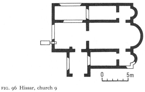
Fig. 96 Hissar, church 9
Its plan was reconstructed from what was left of the foundations plus a partial dig of the western half. The building occupied an area of about 2,000 square metres and contained over 22 rooms; the superstructure - less than a metre high - was faced with smoothed broken stone and had a rubble and mortar fill. So far as could be ascertained, the western part was occupied by a spacious peristyled courtyard on to which the living quarters opened. The columns of mortared brick segments were like those found in many of the churches; their square brick bases stood directly on the earth.
![]()
312
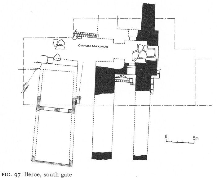
Fig. 97 Beroe, south gate
From the courtyard, two entrances led into what was probably a double, intercommunicating vestibule, with brick-lined entrances and a brick floor. Beyond was the largest room, no doubt the triclinium. Many fragments are evidence of glazed windows. It is suggested that eastern apsidal projections were semicircular towers, constructionally linked with the building, and that a larger rectangular tower projected from the centre of the east wall. Evidence for the nature of the superstructure is, however, slight, and complicated by the likelihood of two building phases, the first in the late fourth or early fifth century.
The walled area of Hissar, comprising some 30 hectares, was 2 hectares larger than that of Nicopolis-ad-Istrum. The two cities must have formed an interesting contrast in the fourth century, as indeed they do today.
VI. BEROE
Fourth-century Beroe, the ‘considerable and rich city’ of Ammianus Marcellinus, did not long enjoy this prosperity. The many small coin hoards show how seriously the Visigothic wars affected its economy, although the city’s sack and destruction was left to the Huns. Beroe is mentioned by Procopius as a city, like Philippopolis, vulnerable and needing restoration under Justinian’s programme, but the work may have already started and taken time to complete.
![]()
313
The refortification and building programme of the end fifth or early sixth century was on a large scale. The second-century wall, already once strengthened, was not only partly rebuilt, but a new wall, some 2 to 4 metres from the old, also surrounded the city. It was metres thick, constructed in opus mixtum with bands of stone a metre wide between bonding courses of four or five layers of brick.
The most important sector so far studied is the south gate (Fig. 97) discovered in 1962. Modelled on the earlier gate, it consisted of an outer portcullis and inner swing gates, the latter occupying approximately the same site as the second-century portcullis. It is estimated that the tower housing and operating the new portcullis must have been about 12 metres high. Posterns opened from the propugnaculum into the intra-mural corridor and, presumably, to staircases ascending to the rampart-walk. On the western threshold a bronze coin of Anastasius constitutes a terminus ante quem for the new defence phase.
The city, temporarily secure behind its double walls, underwent a major rebuilding programme in the sixth century, using the same plan. Owing to a destruction layer formed by the fifth-century sack, the new streets were some 80 centimetres higher. The new surface was gravel, but brick shafts with openings at street level carried sewage down to the original drains. Buildings were repaired or restored, and new ones were built. Pillars, capitals, and other materials were re-used, sometimes very much at random. The floor levels of the sixth-century houses varied. One house had a sixth-century mosaic floor laid 60 centimetres above an older mosaic. A house by the south gate also overlaid an older dwelling (see Fig. 97). Its stone-paved forecourt opened on to the cardo maximus, West of the forecourt, two rooms containing dolia were probably storerooms, with living accommodation on an upper storey. Coins of Alexander Severus were found in the foundations of the earlier phase.
The house with the Constantinian mosaic (p. 201) retained its original floor, exterior walls, and some other parts, but was generally reconstructed (Fig. 98). On the east a series of little rooms, probably shops, had no access to the rest of the complex. Two entrances were on the south, where pilasters projected at regular intervals. One led into the south-west part, where no building remains were found; perhaps it was a yard or garden. East of this, bordering the decumanus, was probably a small working area, consisting of two little rooms built in opus mixtum, a court - also with a southern entrance - with a small open pool faced with marble slabs, a big stone mortar, five or six clay dolia, re-used drums of marble columns, and an altar, as well as stone slabs set about 60 centimetres above the floor, perhaps seats or low working surfaces. The north part of the house, which has not been published in any detail, seems to have been residential, keeping the old dining room and adjoining ‘kitchen’. Nearby were two impost capitals, dated to the sixth century. Of fine marble, carved with a cross surrounded by acanthus leaves, one has an eagle between the volutes at the base, the other a grinning face (Pl. 187). These must have been carved for a church.
With its new fortifications, Beroe resisted an Avar attack in 587 to survive until the reign of Tiberius, whose coins were the latest on the sixth-century streets. Eventually the city fell to and was sacked by Avars or Slavs, but was not left entirely deserted. In the centre of the Constantinian mosaic floor a later structure appeared. Of fragments of brick and stone mortared with mud, it had two square rooms, without doors, their dimensions 3 and 2 metres.
![]()
314
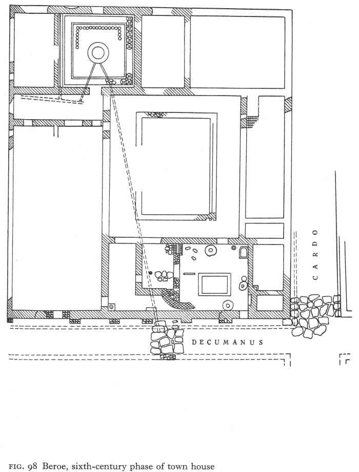
Fig. 98 Beroe, sixth-century phase of town house
![]()
315
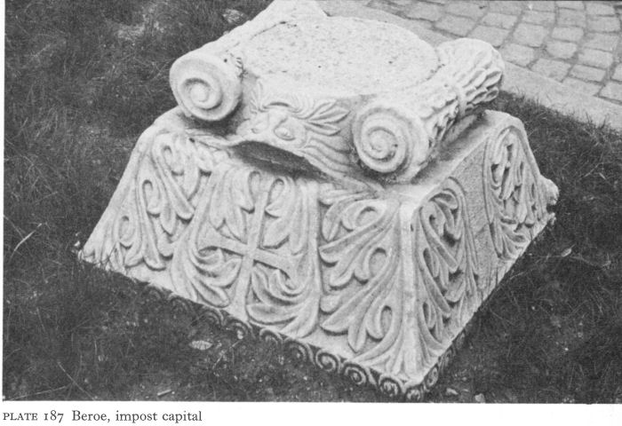
Plate 187 Beroe, impost capital
These were identified as zemlyanki, or dugouts, which continued to use the mosaic for a floor. As the potsherds in the vicinity are not considered Slav or Bulgar, these are assumed to be dwellings of survivors, but the scale of excavation is too limited for the evidence to be conclusive. Nevertheless, the walls were by no means entirely destroyed, and in 778, when they were restored by the Byzantine empress Irene, the city temporarily assumed the name of Irinopolis. Evidence of this restoration was found at the south gate and in other parts of the wall that have been excavated.
VII. CHATALKA
Outside the south-east corner of the pars urbana of the Chatalka villa a small chapel was built, probably in the third quarter of the fourth century; the site chosen was not that of the earlier sanctuary of the Thracian Horseman. Destroyed, together with all the buildings on the estate, by the Visigoths, the little church was later rebuilt and in the ruins of the villa a modest hamlet grew up. The more distant cemetery continued in use, its burials now Christian. Coins show that this settlement existed until about the middle of the fifth century, so that Hun devastation seems certain.
By the sixth century, it appears that the surviving population had migrated to a naturally defended site on a hill overlooking the abandoned villa - which became its cemetery in the medieval period. This settlement - and similar ones in the area - showed by its thick culture layer and comparative size that it was neither a military fort nor a temporary refuge but a permanent village. In 1965 soundings indicated that an area of about a hectare was inhabited, enclosed by double stone walls between 5 and 10 metres apart, with only one tower, a 6-metre square structure projecting from the inner wall. Inside were the foundations of
![]()
316
buildings, a cistern, and a mass of pottery dated from the sixth to the fourteenth centuries, as well as a few coins from the sixth and the tenth-eleventh centuries.
VIII. THE EASTERN RHODOPES
The Haskovo mineral baths, according to coins, continued in use until early in the sixth century. In one complex, the drainage channel yielded coins up to the reign of Anastasius; in that of the large pool, the last coins were of Justin I, but Theodosius II was the most commonly represented. Signs of repair to this pool included the use as building material of two pagan funerary stelai and a fragment of a votive tablet to Herakles. Probably the baths were damaged by the Visigoths about the time of their victory at Hadrianopolis, but, unlike the Armira villa, were restored and enjoyed a new popularity in the first half of the fifth century. Final destruction probably occurred towards the end of the sixth century by Avars or Slavs; it was so thorough that the baths were abandoned and the springs forgotten. The next coins found were nineteenth-century Turkish.
The Sveti Duh fort above the baths was still in use during the Early Byzantine period. Strategic considerations and the need for a refuge appear to have ensured continuity of habitation here, albeit with intermittent periods of destruction and changes of ownership, into the twelfth century. During the reign of Heraclius, Armenians were transported into the area in an effort to counteract the mass settlement of Slavs, but how long the fort remained in Byzantine hands is unknown; there are signs of Bulgarian occupation in the ninth century.
A little medieval church inside the fort, at least up to 1936, was the scene of a moving annual ceremony, when the villagers from the country round about gathered on the eve of Pentecost, the patronal festival, to celebrate a mass for the souls of those who had died in the battle at nearby Klokotnitsa - a great Bulgarian victory over Byzantine invaders - in 1230. It suggests an important medieval role for the fort which current excavations may support.
NOTES
1. Comnena, A., Alexiad XIV, viii, The Alexiad of Anna Comnena, trans. Sewter, E. R. A., Harmondsworth, 1969, 463.
2. Koco, D., Godishen Zhornik Filozofski Fakultet 19, Skopje, 1967, 257 ff.
3. Fortunately a careful examination was carried out and some reproductions of the then existing paintings made. (See under A. Frolow and A. Grabar in site bibliography).
4. Changova, I. and Shopova, A., Rodopski Shornik II, Sofia, 1969, 181 ff.
14 The Black Sea Coast (II)
I. MESAMBRIA AND THE SOUTH
In the south-eastern province of Haemimontus in the Diocese of Thracia, Hierocles put Anchialos as second city to Hadrianopolis. Third came Deultum. Both were episcopal seats. Anchialos was an important centre in the struggle against the Avars, both the city and its mineral baths at Aquae Calidae having been respectively refortified and fortified under Justinian. Procopius especially mentions that
Emperors of earliest times used to allow this place [the baths] to remain unwalled from ancient times, though such a host of barbarians dwelt nearby; and sick persons used to visit the place, gaining relief at the cost of danger. Therefore the Emperor Justinian made it a walled city, as it now is, and thus made the cure free from danger. [1]
The baths were much frequented during the sixth century and, according to Michael the Syrian, Anastasia, wife of Tiberius II Constantine, took the cure here and presented purple vestments to the church of Anchialos. Several years later, when the Avars were in possession, Theophylact Simocattes refers to the residence here of the khagan’s harem; Michael the Syrian writes that the wTalls were overthrown and that the khagan had flaunted on his own person the vestments of Anastasia. Some of the buildings remained standing until the arrival of Crusaders.
Apollonia was already known by 431 as Sozopolis (city of the Saviour), a neat transition of protectors preserved in the modern name of Sozopol. It is mentioned in the struggles between Anastasius and Vitalian, and, although not among Procopius’s list of cities fortified or strengthened, its bishops continue to be recorded after the sixth century. So far only chance-found architectural fragments remain from the Early Byzantine period.
Little is known about Mesambria, also an episcopal centre, but its archaeological monuments demonstrate both prosperity and power of survival. The Hellenistic fortifications, perhaps repaired, probably continued to serve the city during its period of relative obscurity, but a new wall was built during the Late Roman or Early Byzantine period. Although much still survives, as can be seen from the varying methods of construction it was frequently and sometimes extensively restored until its final decay in the late medieval period. Without help from building inscriptions or other written sources, no exact chronology can.be established. Sectors of the Romano-Byzantine wall investigated concurrently with the Hellenistic structure showed conclusively that the two ran roughly parallel; the deeper foundations of the earlier wall were not re-used. Publication, although detailed, is admittedly incomplete and the finds have not yet been fully analysed.
The west and only gate, which is still the entrance to modern Nesebur, thus hindering excavation, was flanked by virtually identical pentagonal towers projecting from the curtain wall (Fig. 99). Parts of the north tower are preserved to a height of nearly 6 metres, the south tower up to 3 metres.
317
![]()
![]()
318
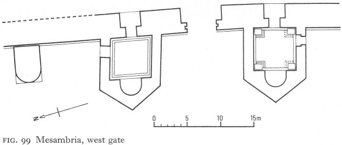
Fig. 99 Mesambria, west gate
The gate is built within the 3.80-metres thickness of the curtain wall. In the outer part, which was faced with large andesite tufa blocks and only 4.40 metres wide, were remains of a portcullis groove. In the inner part, where the opening widened to 6.10 metres, double swing doors were closed by a cross-beam, the holes to contain it being still visible.
Plate 188 shows, viewed from the west, part of the northern gate tower, with its eastern entrance (extreme right) and the north postern, beyond which the curtain wall stretches north to a projecting U-shaped tower. A variety of building methods can be seen - a single layer of the rusticated ashlar above larger, rougher blocks outlining the angle of the pentagonal tower; the stone-walled, brick-vaulted entrances; and, most clearly visible on the U-tower, opus mixtum with bands of three and four courses of brick, thickly mortared. This tower, originally rectangular, stood between the gate and a large projecting circular tower which defended the angle at the sea approach.
A joint between the wall and the circular tower showed the latter to be a separate construction, and excavation of the foundations revealed an originally rectangular plan. The tower, now partly restored, had an overall diameter of 7.15 metres; the walls, 85 centimetres thick, were of opus mixtum and three building phases could be discerned. As in the gate towers, there was an external postern, but no means of communication between the ground floor of the tower and the interior of the fortress could be traced. Remains of a corresponding but much smaller projecting round tower were found at the south angle of the walls, and of a rectangular tower which was a medieval addition between it and the gate.
I. Venedikov has suggested the second half of the fifth or the beginning of the sixth century for the construction of the gate towers and the opus mixtum work to various times between the fifth and tenth centuries. There is no historical evidence that the earlier walls were destroyed by barbarian invasions; earthquakes may have caused damage or the city defences simply needed strengthening. Mesambria was strategically important to the Byzantine empire and both Zeno and Anastasius were zealous builders. The omission of Mesambria by Procopius is an argument for a date well before the reign of Justinian. The powerfully reconstructed fortress seems to have survived the Avar attacks and historians continue to refer to the fortified city of Mesambria during the seventh and eighth centuries.
![]()
319
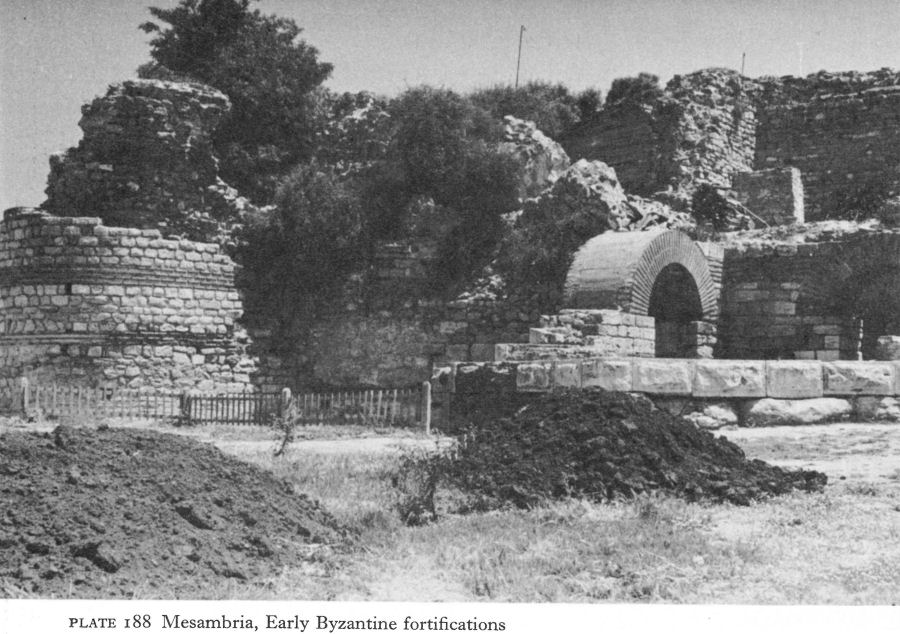
Plate 188 Mesambria, Early Byzantine fortifications
During these years inland trading activities were incommoded by the fact that Mesambria and Anchialos frequently served as Byzantine bases in the wars against the new Bulgarian state. The immediate hinterland continued to be rich farming land - it is recorded that the future emperor Leo III gained the favour of Justinian II at Mesambria in 705 by offering his services and a gift of 500 sheep. But as the territory south of the Stara Planina came under Bulgarian rule, the city’s traditional skill in accommodating itself to circumstances proved once more of value. After a short-lived occupation by the Bulgarian tsar Krum, the city remained in Byzantine hands until the fourteenth century.
The latest excavations have included an unpublished Early Byzantine three-naved basilica not far from the north round tower. Another, much further along the north coast, was excavated some 50 years ago. Twenty-eight metres long and 18 metres wide, but partly eroded by the sea, it is today preserved to a height of at most some 2 metres (Pl. 189; Fig. 100). The church had three main building phases, only the first within the Early Byzantine period; this is distinguished by careful ashlar construction with occasional layers of brick and tufa.
A three-sided apse terminated the central nave and semicircular ones with triconchal interiors the aisles. The north aisle has mostly been eroded. The sanctuary was tripartite and stone piers separated the nave and south aisle; according to the excavator, the north aisle appears always to have been divided by a wall from the nave. The narthex was originally tripartite, the divisions being later removed, possibly when two rooms were annexed to the west. The few finds include marble architectural fragments and broken bricks bearing the sign of the cross and the name of Justinian.
![]()
320
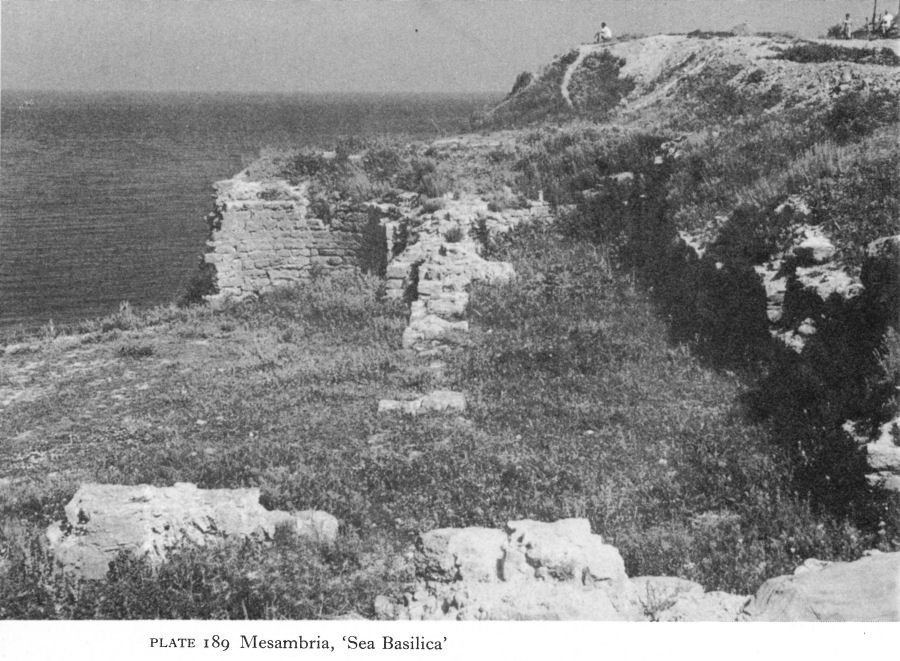
Plate 189 Mesambria, ‘Sea Basilica’
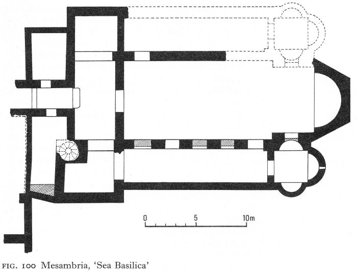
Fig. 100 Mesambria, ‘Sea Basilica’
![]()
321
Mesambrian links with Constantinople in the sixth century were close and, bearing this in mind, the church is dated to early in the second half of the sixth century. The second and third reconstructions, using only the south aisle, were separated from the abandonment of the original church by a long period of years. The church, known in archaeological literature as ‘the Sea Basilica’, may at some stage have been dedicated to the Virgin Eleousa.
In contrast, parts of the church known as the Old Metropolis, in the centre of the little town, are preserved to roof height (Pl. 190). It was a three-naved basilica with a single, three-sided apse, a narthex, and an atrium (Fig. 101). The nave and aisles, separated by five pairs of massive opus mixtum piers, were unusually short in relation to their width, so that, without the narthex, they were almost square. The deep apse contained a synthronon. The narthex was divided into three rooms corresponding to the nave and aisles. Very little of the atrium remains, but part of a north side-chamber has been found and probably there was a similar one on the south. Above the aisles were galleries with arches almost as large as those below. The east end as it is today is clumsily proportioned, the roof line here being clearly the result of a makeshift repair.
Both the original form and date of the Old Metropolis are disputed. The church is thought to have been either a basilica with clerestory lighting and without galleries above the aisles, or else a ‘barn church’ with side-galleries and covered by a single roof. Dating ranges from the fifth to the eleventh centuries.
A recent survey with particular attention to the masonry throws fresh light on both problems. [2] Several building phases have been identified which resulted in drastic alteration of the original conception yet little change to the ground plan.
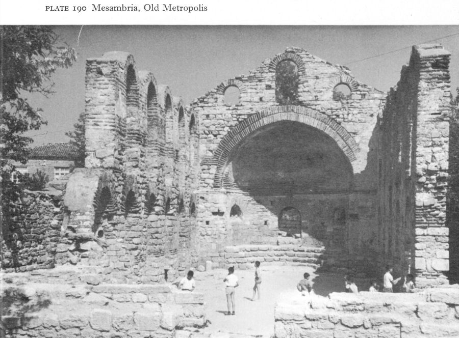
Plate 190 Mesambria, Old Metropolis
![]()
322
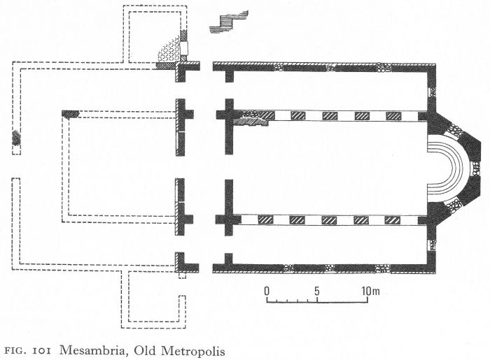
Fig. 101 Mesambria, Old Metropolis
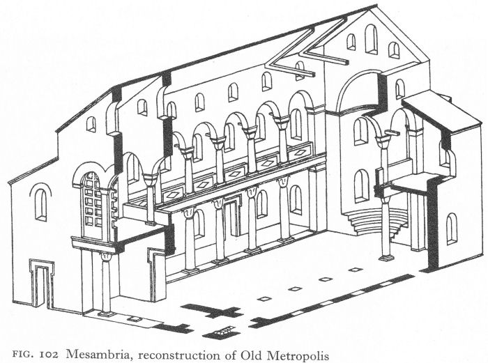
Fig. 102 Mesambria, reconstruction of Old Metropolis
![]()
323
According to this analysis, the first restoration followed a razing of the original church to, at most, little more than a metre above the ground, a level where a band of five courses of brick ran above a wall of dressed stone. The new walls incorporated the remains of this band. The arched piers today separating nave and aisles date from this second period, similarly the squat arch and semi-dome of the apse.
As the plan closely resembles that of St John Studios in Constantinople, it is suggested that in the Old Metropolis, too, the nave and aisles were originally separated by pillars on low stylobates. There would have been galleries above the aisles and the narthex, with clerestory windows above to provide more light for the nave. The height of the apse would have corresponded to that of the galleries (Fig. 102). Although there is no supporting archaeological evidence, this is a feasible explanation of many puzzling anomalies. The ground plan is appropriate to a church of the fifth or first half of the sixth century in a city closely linked with the capital and for Mesambria to have copied the famous church of St John Studios would not be surprising. The latter being dated to about 463, a little later in the fifth century is reasonable for the Old Metropolis.
The thorough destruction of the original building argues deliberate demolition rather than accident, and the disappearance of any pillars and sculptural ornament that existed suggests that rebuilding was not immediate. It is proposed that the destruction occurred in the sixth century and the rebuilding in the seventh or eighth, the grounds being the construction technique, and that by the ninth century the basilica had been replaced by the inscribed cross plan in Byzantine church architecture. However, in Constantinople the Hellenistic basilica was already obsolete in the sixth century, the latter part of which also saw the general acceptance of the triple apse. There would surely have been a triple apse and tripartite sanctuary in a seventh- or eighth-century rebuilding.
It is more likely that the first church was destroyed during an unrecorded raid or other disaster soon after its construction in the latter part of the fifth century and rebuilt at the end of the century or early in the sixth. A rebuilding during this period - perhaps coinciding with the new fortifications - would account for the single-apsed basilical form, and haste due to the insecurity of the times for the clumsiness of the reconstruction.
II. ODESSOS AND THE NORTH
Odessos, which had regained its earlier importance as a base for Valens’ operations against the Visigoths, continued as a busy commercial and diplomatic centre throughout the fifth century. In 442, a mission from Theodosius II to Attila encountered another embassy in Odessos. During the sixth century, as well as being a base for campaigns against the Slavs and Avars, the latest that of 595 led by Maurice’s brother Peter, it increasingly became a centre for refugees from the lost or endangered cities along the Danube. There is little doubt that the fortifications, mentioned by Procopius, were kept in good order.
Administratively, Odessos reached its peak in 536 when Justinian made it the military and administrative centre (quaestura exercitus) of a union of Moesia Secunda, Cyprus, the Cyclades, and Caria. Sea communications appear to have been the only common basis for this geographically widely separated region.
![]()
324
Fifteen months later, after a stream of pleas from inhabitants of Rhodes and Cyprus against the necessity for voyaging to distant Odessos, with the attendant risk of barbarian attack, to lay a case before the quaestor, the emperor agreed to move the judicial function to Constantinople. But the other functions remained.
The 65th novella of Justinian, concerned with Tomi and Odessos, is illuminating evidence of the wealth of the Church, accumulated through official ‘inheritance’ of the lands and goods of the older religions and gifts from pious and expiating Christians. The lands included vast vineyards, wine now being a major local export. The novella permitted the sale of uneconomic property, for example a vineyard incapable of bearing a good annual grape-harvest or land laid waste by enemy attack, provided that the money obtained was applied as a Christian donor had specified or, in other cases, for appropriate Christian purposes, such as hospitals, orphanages, the general welfare of the poor, and for the ransom of captives, in which the Church took a leading part. It appears there had been forbidden dealings in land to the profit of both laymen and clerics.
Funerary monuments show the continuance of immigration from the eastern provinces. Traders and shipbuilders came from Asia Minor to settle, and the fifth and sixth centuries saw a remarkable growth in the Syrian colony, whose attested occupations included furriers, sellers of linen, and soapmakers.
Within the actual city limits of Odessos, architectural and mosaic fragments have proved the existence of at least four fifth- or sixth-century churches. Although their full-scale excavation proved impossible, K. Škorpil collected and studied the finds for a monograph on the churches in the Varna district. Unfortunately, his work - in manuscript and with the full documentation - was despatched abroad for publication but appears to have been lost. [3] One must hope for its reappearance, for at present it is hard even to identify the find-spots of many important items in the Varna archaeological museum.
However, three early churches near the city - at Galata, Djanavar-tepe, and Pirinch-tepe - have been fully excavated and two of them published. The Galata church was built on top of the old sanctuary of the Thracian Horseman (p. 51). There can have been no appreciable time gap between the latter’s destruction, probably towards the end of the fourth century, and its obviously deliberate Christian replacement. Votive reliefs dedicated to the Horseman were first defaced by hammering - in front of the sanctuary, where many tiny fragments were discovered - and then re-used, face downwards, to pave the south aisle.
The church was a three-naved basilica with a single semicircular apse (Fig. 103). The nave, 17.20 metres long and 6.30 metres wide, was separated from the aisles by rows of six limestone bases standing directly on the earth. All but one of the bases were in situ and fragments of marble columns were in the debris. West of the north aisle and extending alongside the narthex to the entrance of the nave was a baptistery with a square, brick-built piscina. The general absence of tiles and the finding of many nails and remains of beams point to a wooden roof. Fragments of flat thick glass probably came from windows.
As well as a piscina, there was a clay font, its foundations in situ north of the entrance from the narthex into the church. The rest was found, broken and dug into the earth, but has been reassembled (Pl. 191). The pedestal has a double wall, the outer heavily decorated by cut-out geometric patterns and the inner with openings corresponding to those in the outer wall.
![]()
325
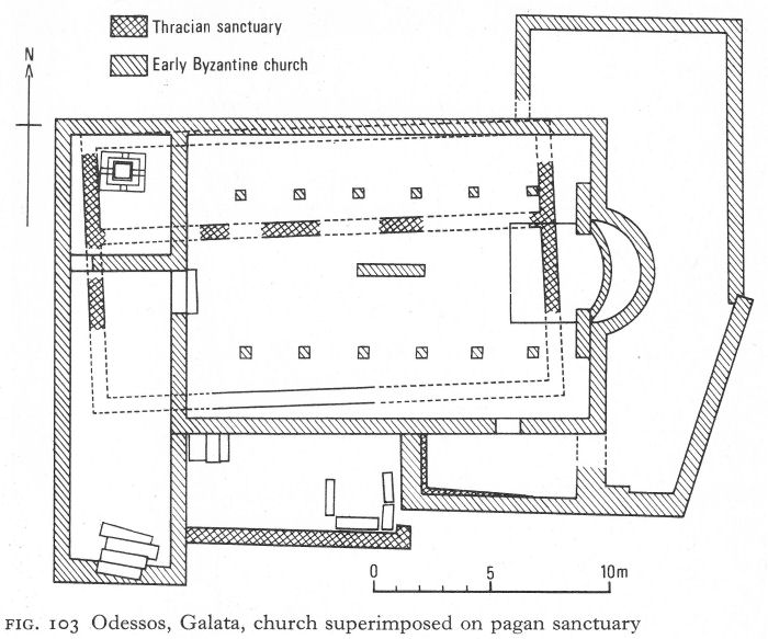
Fig. 103 Odessos, Galata, church superimposed on pagan sanctuary
The top is a wide shallow bowl, 69 centimetres in diameter, with an elaborately ornamented rim. There was an opening for emptying water from the bottom of the bowl, and space between the walls of the round base for a fire to warm it; at the time of discovery ash and embers still remained. Discussing this unusual font, J. Lafontaine-Dosogne points out stylistic parallels in Constantinopolitan sculpture and recalls that in the early fifth century the baptism of infants was encouraged by, among others, St Augustine and probably St John Chrysostom. [4] The early fifth-century date ascribed to the font is also applicable to the church, which probably continued in use until about the end of the sixth century, when it was destroyed by fire.
The site of Djanavar-tepe is a flat-topped hill 4 kilometres south of Varna. The church was excavated by K. Škorpil, but the documentation was among the lost papers. The church was a single-naved basilica with projecting north and south rooms inscribing both apse and narthex (Fig. 104; Pl. 192). A Π-shaped sanctuary occupied the east end of the nave and the apse was lined by a synthronon. One of the narthex annexes was a baptistery, containing a cross-shaped piscina. A large ambo, or pulpit, stood over a brick tomb in the centre of the mosaic floor of the nave. The base of the marble sanctuary screen was found in situ and fragments of its marble pillars stand nearby round the grave of Škorpil. In a small crypt below the sanctuary a valuable triple reliquary was discovered.
![]()
326
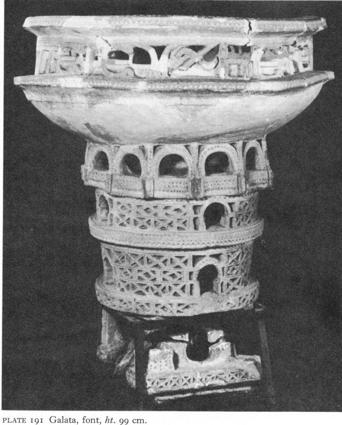
Plate 191 Galata, font, ht. 99 cm.
The remains of the massive opus mixtum walls, between 2 and 2 1/2 metres thick, are particularly striking. Stairs from the eastern side-chambers led to an upper storey and the nave was almost certainly vaulted. The powerful walls and towered projecting rooms suggest a defensive purpose, probably a refuge for the local population, although it is strange that the towers project only to the north and south, and not even to the west to protect the entrance.
As D. P. Dimitrov points out, the resemblance between Djanavar-tepe and such churches as Ivanyani and Tsurkvishte is superficial. [5] Yet, with the Π-shaped sanctuary, it is open to doubt whether the sanctuary is tripartite, and the projecting rooms the prothesis and diaconicon. The combination would be an unusual liturgical compromise.
![]()
327
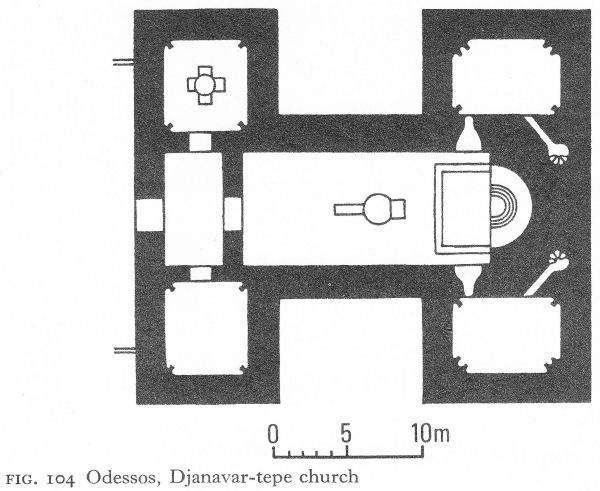
Fig. 104 Odessos, Djanavar-tepe church
Djanavar-tepe is usually dated to the fifth century; in the circumstances it is hard to be more precise about a church that is so much out of the ordinary as well as, despite being levelled almost to the ground, so impressive.
Pirinch-tepe, discovered and excavated by K. Škorpil during the construction of a shipyard, and published in 1910, had two building phases, the later overlaying and using the earlier foundations (Fig. 105). Both were three-naved basilicas with a single apse and a narthex. The earlier apse was probably semicircular and the narthex undivided. The nave was separated from the aisles by colonnades.
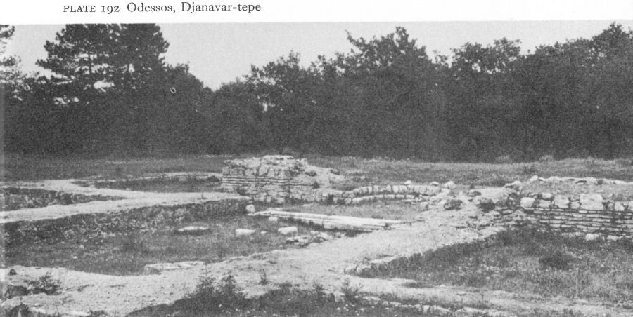
Plate 192 Odessos, Djanavar-tepe
![]()
328
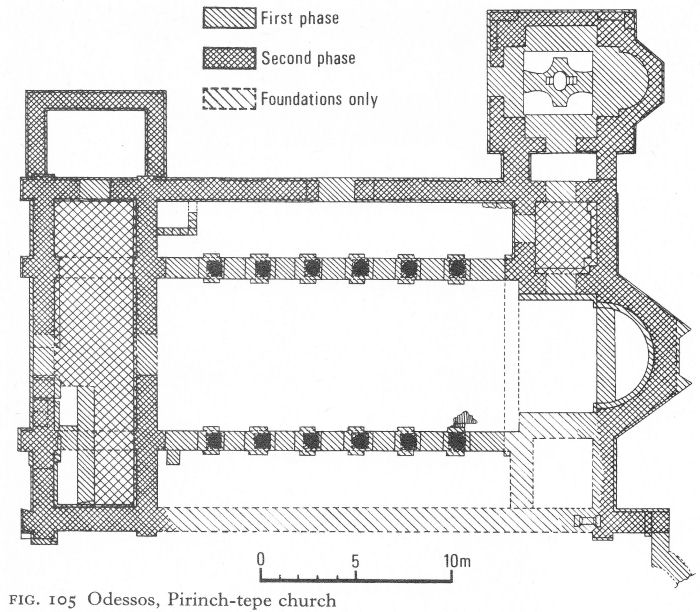
Fig. 105 Odessos, Pirinch-tepe church
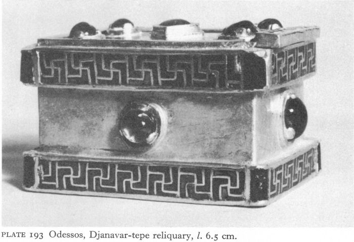
Plate 193 Odessos, Djanavar-tepe reliquary, l. 6.5 cm.
![]()
329
The rebuilt church had a new floor and a three-sided apse. The nave was shortened by converting its east end and those of the aisles into a tripartite sanctuary. Square limestone blocks carried re-used column bases on brick stylobates. One Ionic impost capital was found in the debris, with a few other fragments and pieces of window glass. Later additions also included a rectangular room north of the narthex and a baptistery, with a three-sided apse and a piscina, linked by a small vestibule to the prothesis.
On the basis of coin finds, Škorpil dated the first church to the reign of Constantine the Great, the second to that of Justinian. The possibility, here and elsewhere, that Constantinian coins had an especial sanctity in relation to church building cannot be dismissed, but in any case a fourth-century date is likely for the first phase. The main rebuilding may be Justinianic or a little earlier.
The gold reliquary of Djanavar-tepe (Pl. 193), which had been placed in a silver box which, in turn, was in a miniature alabaster sarcophagus, symbolises the wealth of the Early Byzantine Church of Odessos, perhaps especially of its Syrian community. Contemporaneous with the church, it miraculously remained hidden. The lid has a square emerald in the centre and a sapphire at each corner. The sides, each inset with a larger sapphire, are bordered, top and bottom, by a wide cloisonne band of gold swastikas against a garnet background. The reliquary may have been made by an Odessitan goldsmith but could equally well have come from Constantinople or some other leading city. There are not enough objects of proven origin to reach any definite conclusion.
The sacred treasure of Djanavar-tepe is matched by a collection of Early Byzantine jewellery found by chance in Odessos just outside the fortress wall in an early Roman necropolis where isolated later burials also took place. Although less unusual than the reliquary, the jewellery, nine objects weighing a total of 417 grams and of almost pure gold, over 22 carats, is also magnificent. D. I. Dimitrov ascribes the collection to the sixth century; although clearly the work of more than one goldsmith, this need not involve differences of date or provenance. The two bracelets (one shown in Pl. 194) have a hinged clasp of a type usually thought to have been invented in the late fourth or early fifth century. The main motif is the familiar symbol of the vine, the bunches of grapes consisting of large, re-used pearls with the intervening ‘leaves’ of light green glass.
Perhaps the finest work is in the diadem (Pl. 195), the plain gold band with its delicate poinçonné geometric pattern contrasting with the rich central ornament inset with five round pearls. A Greek cross central pattern, probably originally formed by five flat opals of which only two remain, supported the topmost pearl between two oval plaques of dark emerald green glass.
Completely different in style are a pendant and two belt appliqués. The former is a cross inset with garnet and malachite to form a ‘tree of life’ pattern against a dark red background, a round garnet in the centre (Pl. 196). The belt appliqués have plant motifs using the same materials and technique.
Different again are necklace fragments; one is a medley of irregularly shaped pearls, transparent stones, and pieces of coloured glass, hanging from rounded inset stones or glass, themselves hanging on golden hooks and alternating with granulated gold triangles from which hang smaller pearls or other roundels (Pl. 197).
![]()
330
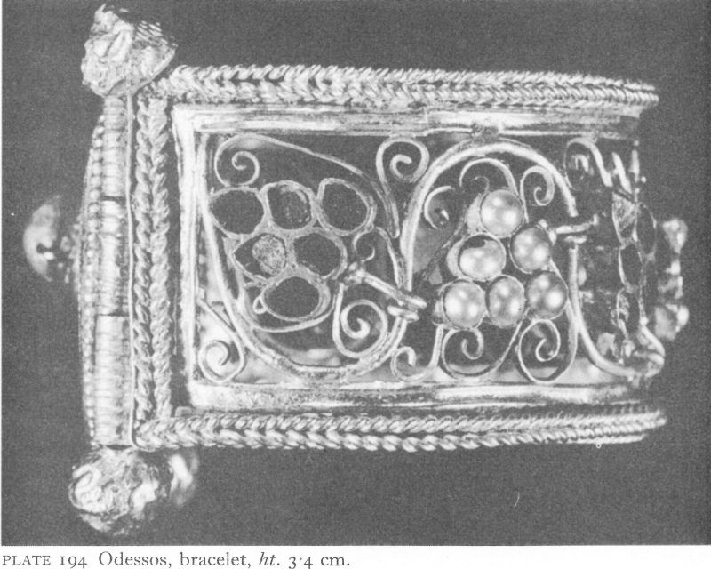
Plate 194 Odessos, bracelet, ht. 3.4 cm.
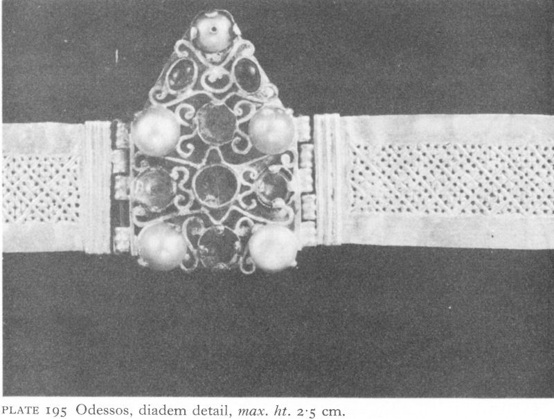
Plate 195 Odessos, diadem detail, max. ht. 2.5 cm.
![]()
331
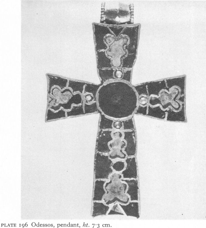
Plate 196 Odessos, pendant, ht. 7-3 cm.
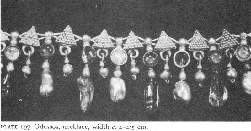
Plate 197 Odessos, necklace, width c. 4-4.5 cm.
![]()
332
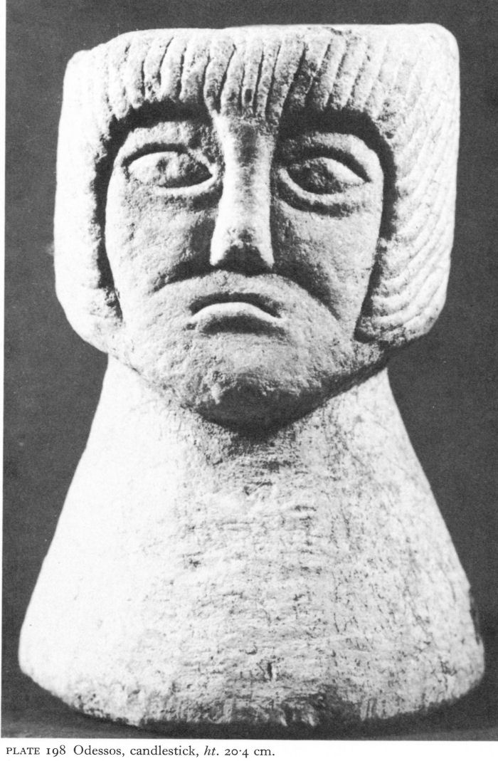
Plate 198 Odessos, candlestick, ht. 20.4 cm.
![]()
333
This barbaric, although skilful, splendour is representative of sixth-seventh-century Byzantine jewellery, a demonstration of the deep penetration of Gothic influence, even in Constantinople.
Barbaric elements are even more apparent in a specimen of - probably - local sculpture. The candlestick (Pl. 198) of greyish marble, found somewhere in Varna, portrays a male head. Dated by hair style and a distant stylistic relationship to works such as the statue of Heraclius at Barletta, it probably belongs to the end of the sixth or beginning of the seventh century, a period when, although military links with Constantinople still existed, Odessos had entered a state of cultural decline.
North of Odessos, little from the Roman or Early Byzantine period has been found either at Dionysopolis or at Bizone, the latter abandoned after an earthquake in the first century a.d., when the population no doubt moved to nearby Cape Charakman. Here Early Byzantine remains include a wall of dressed limestone and a gate defending the neck of the cape at a point only 12 metres wide, and the foundations of a three-naved basilica with a single, semicircular apse and narrow narthex. The comparatively wide nave and narrow aisles, 5.65 and 2 metres respectively, and wide apse suggest a fifth-century date, probably before 450, for this church. It was destroyed towards the end of the seventh century, but life seems to have continued in the settlement for several centuries.
Twenty kilometres beyond Bizone is the long narrow rocky cape of Kaliakra, probably to be identified with Strabo’s Tirizis. Projecting over 2 kilometres into the Black Sea, Kaliakra closes the northern end of the wide bay at the south of which lies Varna. Easily defended at a neck only a few metres across and with steep cliffs on all sides, Kaliakra has only recently been excavated. Early Byzantine Kaliakra was the headquarters of Vitalian, the Romanised son of a Goth, born at nearby Zaldapa (Pobeda), who led a popular revolt against Anastasius in the first quarter of the sixth century. Vitalian succeeded in capturing Odessos and Apollonia and made a series of attacks on Constantinople.
Three defence walls have been found. The first, faced by small dressed blocks, is dated to the fourth or fifth century.
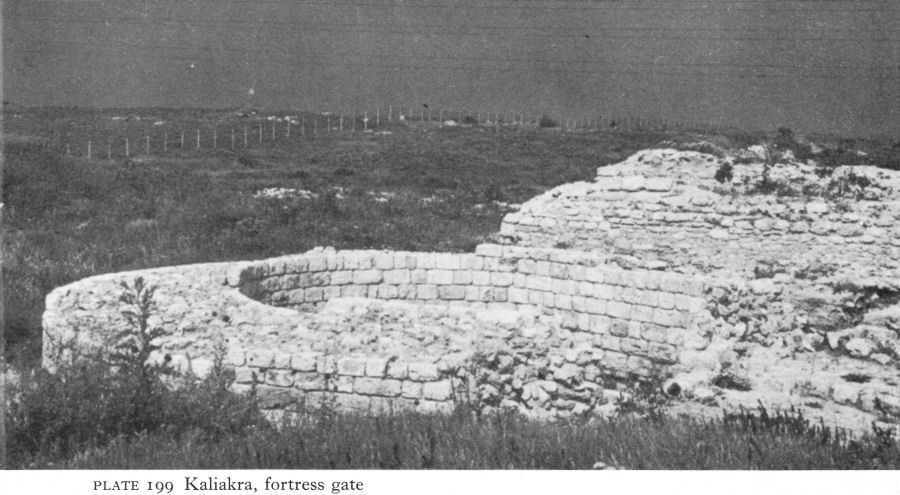
Plate 199 Kaliakra, fortress gate
![]()
334
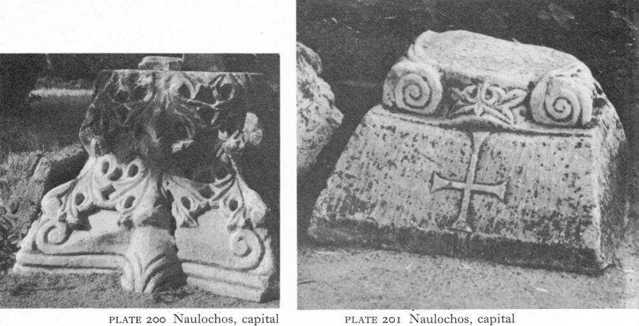
Plate 200 Naulochos, capital
Plate 201 Naulochos, capital
It was 2.90 metres wide and had square and U-shaped projecting towers and bastions which also flanked the single entrance (Pl. 199). The second, similar in construction, is attributed to about the sixth century, so may have been due to Vitalian or part of the later Byzantine fortification programme. The third wall was medieval.
South of Odessos, Erite or Ereta (Dolni Bliznyak) at the mouth of the Kamchiya river (ancient Panysos) is marked in the Tabula Peutingeriana as the first station south of Odessos on the road to Constantinople. The site was identified by K. Škorpil at the end of the last century, when he described it as a triangular fortress, built of cut stone, on a high peak above the left bank protecting a bridge across the river of which the remains were still visible. Excavations in 1939 brought to light - in spite of quarrying and erosion - the remains of a three-naved church. At least 30 metres long and 20 metres wide, the nave and aisle were divided by white marble columns with Corinthian capitals, their bases standing on square limestone blocks as in the second phase of Pirinch-tepe, which it also resembled in construction and materials. Coins of Justinian and Maurice found in and near the church suggest it was built in the reign of the former and that the settlement continued to exist into the seventh century.
Farther south, just before the last spur of the Stara Planina reaches the sea, was Naulochos (Roman Templum Iovis - modern Obzor), where a few architectural fragments, lying in the public gardens, are forlorn evidence of Early Byzantine prosperity. They include capitals which must once have crowned the columns of some not particularly humble church (Pls. 200, 201). Also from this locality comes a remarkable life-size sandstone portrait head (Pl. 202). The left side is broken off and the left eye much damaged.
![]()
335
Plate 202 Naulochos, portrait head, ht. 26 cm.
![]()
336
D. P. Dimitrov suggests that traces of the sculptor’s hammer on the hair over the right ear show it to be unfinished, local work. The head, despite strong stylisation, especially in the hair, retains something of Roman art, but the impressive frontal gaze with deliberately exaggerated eyes proclaims it a rare example of Byzantine portrait sculpture. Dated between the mid-fifth and the mid-sixth centuries, this battered fragment records the vitality of the civilisation which, in spite of barbarian pressures, survived in the cities of the Black Sea coast.
In the interior it was very different. Theophylact Simocattes relates that, having defeated the Avars at Yiminacium (Kostolac, in Yugoslavia) in 601, the Byzantine general Comentiolus halted on his way back at Novae and asked the inhabitants for a guide to take him along the so-called Trajan’s Road over the Stara Planina. He was told that there was only one man, aged 112, living 12 miles away, who knew the road. When the old man was found, he refused to act as guide, saying that the road had not been used for ninety years and was in any case unlikely to be practicable in winter. Comentiolus succeeded in reaching Philippopolis, crossing the mountains by either the Shipka or the Troyan pass, but only after great hardship and many losses. Only a few years after his journey almost all the cities created by Rome had fallen and, in what is now Bulgaria, in many ways the wheel had turned full circle to the situation which had prevailed when the Greeks first settled their colonies along the coast.
NOTES
1. Procopius, De Aed. Ill, vii, 19-23, trans. Dewing, H. B., Procopius, VII, Buildings, London, 1940, 219.
2. Boyadjiev, S., Byzantino-Bulgarica I, 1962, 321 ff.
3. Dimitrov, D. I., IBAI XXX, 1967, 42, n. 11.
4. Lafontaine-Dosogne, J., CA XVII, 1967, 45 ff.
5. Dimitrov, D. P., Kratka Istoriya na Bulgarskata Arhitektura, Sofia, 1965, 55.