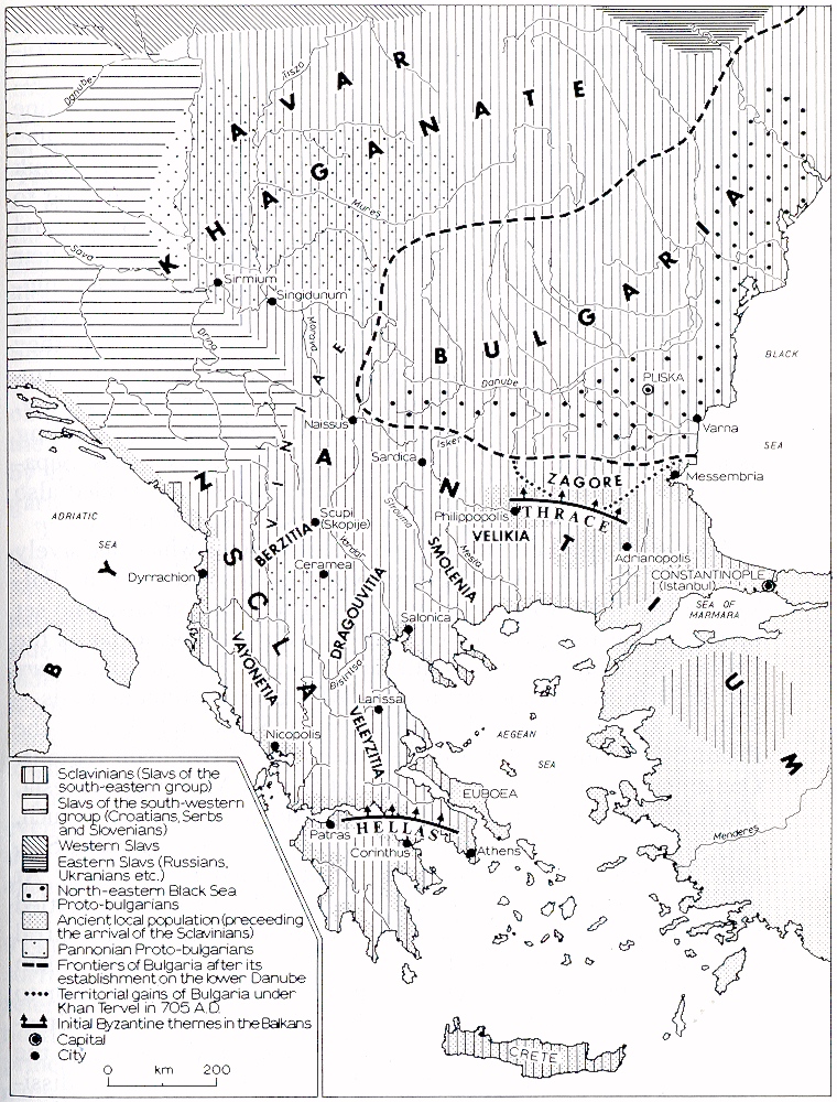
Fig. 1. Ethnic and political changes in the Balkans towards the end of the seventh century A.D.
PETER KOLEDAROV
(p. 293-317 in An Historical Geography of the Balkans, edited by Francis W. Carter, Academic Press, 1977)
Ethnical processes and political events have always left an imprint on geographical nomenclature. This is most vividly seen in southeastern Europe, and in the Balkans in particular because compared with the other regions of the Old World the former have been subjected to frequent and profound changes.
A study of the emergence and the evolution of local names in this area shows that not only have they been replaced by other names or had their image or sound modified, but in certain cases the old toponyms were preserved, though with a new content, or cropped up in entirely new localities. The study and elucidation of these phenomena and the causes for their emergence reveal certain patterns and also help to eliminate the numerous errors and delusions about the past and present of the Balkans.
It is impossible, within the framework of a single chapter, to examine comprehensively the complicated question of geographical nomenclature in all of this part of Europe. It is for this reason that we shall deal only with the more important regional names in the eastern and central parts of the Balkans. The differentiation of that area also justifies the restriction of the subject in relation to it, geographical scope. In Antiquity the eastern part of the peninsula was inhabited by Thracians and Dacians, and the western part by Illyrians. Whereas the former fell under the influence of Hellenism and largely retained its traditions, the latter maintained closer ties with Rome. This ethnical differentiation in the period preceding the division of the Old World, as well as the proximity of Constantinople in cultural and geographical aspects, determined that the area under review remained in the Empire's eastern part. After settlement in the area by the Slavs and Proto-Bulgarians, the differentiation was aggravated and could be traced in the ethnicl and political development of the following centuries.
Byzantium, being the heir to Rome, took over its administrative division and its nomenclature. The names of the provinces Thrace, Illyria, Macedonia, Scythia, Dacia, [1] etc. were established and adopted by the old inhabitants of the Balkans, since in general terms they corresponded to the countries settled in by the various groups (ethnicons). These names of provinces were not only administrative units but became geographical concepts. Duri their continuous usage in the course of the first six centuries A.D. the Roman nomenclature of the provinces and dioceses in the Balkans gained a wide popularity and a definite significance in parts of the Old World including its western domains. It should be stressed that a precondition for this was a combination of political and ethnical factors.
Radical changes occurred in the territorial scope and the ethnic composition of the Byzantine Empire in the sixth and seven centuries (Fig. 1). The Emperor in Constantinople was able keep under his sceptre barely a third of the territory, he had ruled in earlier centuries. The Arabs and the Persians conquered considerable parts of his domains in Africa and Asia, whilst at the same time his rule over Italy and the Balkan Peninsula was alre very much restricted. The waves of 'barbarian' invasions were followed by prolonged and even more devastating raids by the Slavs (Sclavinians) [2] during the last decades of the sixth century. The Sclavinians, a south-eastern Slavic group were also called 'Dacians' or 'Bulgarians', and eventually provided the basic component of the Bulgarian nationality. [3]
Fig. 1. Ethnic and political changes
in the Balkans towards the end of the seventh century A.D.
Benefitting from the unprotected northern Byzantine frontiers (a result of warfare waged by the Empire in Asia) the Sclavinians came down from their initial base in modern Wallachia and Moldavia, mainly along the valleys of the Rivers Morava and Vardar. They occupied the land to the south and south-east, to a line running from the estuary of the River Koloubara at the Danube passing across the ridges of the Roudoka, Stolova and Kopaonik mountains and the north Albanian Mountain Range, and ending to the north of the town of Dyrrachion (the Old-Bulgarian Drach and present-day Durresi in Albania) and the Shkodra Lake. [4] The settlements were most densely populated in the heart of the peninsula, in the diocese of Macedonia ( which also embraced Greece).
The new settlers used it as their second base, and from it the spread eastwards and south-eastwards. Thus, the Slavs came permanently to the former provinces of Moesia, Dardania, Thrace, Thessaly, Epirus, Central Greece and the Peloponnesus, reaching as far as the coasts of the Black, Adriatic and Aegean seas. Separate groups crossed in their vessels (monoxyles) and landed also on the islands of the Archipelago as well as in Asia Minor. [5]
A second important ethnical and political factor which decisively influenced the outlook and geographical nomenclature of the Balkans at this time, was the arrival of the Proto-Bulgarians, who set up their state along the lower reaches of the Danube, as far as the Balkan Mountains to the south, and received recognition de jure and de facto by Byzantium in A.D. 681. After continuous raids both on their own and in alliance with Slavs and Avars – the Proto-Bulgarians established their domiciles in two main regions. One embraced the former provinces of Scythia Minor and Moesia, and the other was located in central Macedonia. Led by Asparouch, they arrived in Moesia from the northern coast of the Black Sea, after Koubrat's 'Great Bulgaria' disintegrated c. A.D. 650. At almost the same time, the second group, headed by Kouber, settled in the area between Thessalonica and Bitolja, with their central settlement in Ceramea, in the midst of the land of the Sclavinaijj tribe of the Dragouvites. This group arrived from Pannonia, or to be more exact from the area of Sirmium (modern Sremska Mitrovitsa, Yugoslavia), which then was included in the realm of the Avar Khaganate. Kouber's Proto-Bulgarians being Avar dissidents, Constantinople counted on breaking up the mass of Slavs and their alliance with the Avars, so Byzantium welcomed them and asked its allies, the Dragouvites, to provide food supplies. [6]
A part of the local population of the plains withdrew to the mountains,
while another, the Hellenized and Romanized elements, went to the towns
and to the territories where the Empire was still in a position to protect
them. Along with the Aegean islands, Thrace was the most significant bulwark
inland, as the latter was of vital importance for the defence of the capital
city. In the rest of fhe peninsula, the Empire had under its control only
Thessalonica (Salonica) and some of the stronger fortresses with the adjacent
strips of land along the sea coasts and the more important highways. The
power of the Emperor was only nominal in the territories occupied by the
Slavs as Sclavinian chiefs (princes) were in control there. The territory
of each tribe acquired the name 'Sclavinia' (![]() ),
obviously in accordance with the proper name of the Slavs from the south-eastern
group. The term was in common use most often by Byzantine writers in the
plural –
),
obviously in accordance with the proper name of the Slavs from the south-eastern
group. The term was in common use most often by Byzantine writers in the
plural – ![]() or in the vulgarized version
or in the vulgarized version ![]() ,
the Latin form being 'Sclaviniae'.
,
the Latin form being 'Sclaviniae'.
The Czech historian, Lubor Niedelie, first drew attention to the fact that since the middle of the seventh century that name meant Macedonia. [7] Most of the writers interpreted the term as a designation of independent [8] Slav principalities, which were found outside Bulgarian territory [9] or more generally, as 'Slav land'. [10] The oldest references (at the turn of the sixth century) [11] to 'Sclaviniae' relate to the land, inhabited by Slavs and located along the left bank of the Danube, i.e. their first base in present-day Wallachian lowland.
In the chronicles of Theophanes the Confessor, [12]
dealing with events between 658 and 809-810, the 'Sclaviniae' already implied
the principalities west of the River Mesta, while in Narratio anonyma
e Codice Vaticano and in Scriptor Incertus de Leone Armenio (the excerpts
about the Byzantine-Bulgarian Wars of 811 and 814) [13]
the term has a different meaning. The first mention of 'the surrounding
Sclaviniae' (![]() )
probably refers to the principalities near Pliska, along the western and
northern frontiers of Bulgaria (the Timokites, Moravites and principalities
to the north of the Danube) and the second mention namely, 'all Sclaviniae'
(
)
probably refers to the principalities near Pliska, along the western and
northern frontiers of Bulgaria (the Timokites, Moravites and principalities
to the north of the Danube) and the second mention namely, 'all Sclaviniae'
(![]() ), also refers
to those in modern Macedonia. The lack of data makes it impossible to discern
the basis of the relationship between the Bulgarian Khan Kroum and the
Slav principalities. One may assume that the relationship was based on
an alliance with the Bulgarian state, and that the Sclavinian principalities
were buffer areas between it and the Avar Khaganate. The Slavs obviously
sided with Khan Kroum in his struggle against Byzantium, but it seems that
they preserved their independence. It is in this sense that the term should
be interpreted in the name given (in the ‘List of Names of the Bulgarian
Khans') to the territory along the left bank of the Danube, Княжение
оубоу страноу Доуная. Thus, it should be the Slav-Bulgarian synonym
of the Byzantine 'Sclaviniae', and reveals the political status of independence
of the Sclavinian tribes. The latter, as we shall see later, gave their
names to the regions they occupied.
), also refers
to those in modern Macedonia. The lack of data makes it impossible to discern
the basis of the relationship between the Bulgarian Khan Kroum and the
Slav principalities. One may assume that the relationship was based on
an alliance with the Bulgarian state, and that the Sclavinian principalities
were buffer areas between it and the Avar Khaganate. The Slavs obviously
sided with Khan Kroum in his struggle against Byzantium, but it seems that
they preserved their independence. It is in this sense that the term should
be interpreted in the name given (in the ‘List of Names of the Bulgarian
Khans') to the territory along the left bank of the Danube, Княжение
оубоу страноу Доуная. Thus, it should be the Slav-Bulgarian synonym
of the Byzantine 'Sclaviniae', and reveals the political status of independence
of the Sclavinian tribes. The latter, as we shall see later, gave their
names to the regions they occupied.
The latest mention of the 'Sclaviniae', as a collective concept, appears in Anastasius the Librarian's Chronographia tripertita (compiled in the second half of the ninth century). The reference in the passage concerning events in 785, when Constantine VI conquered the Sclaviniae of Macedonia ('Sclavenias penes Macedoniam'). We may draw the conclusion that in this case, Macedonia implied the proper province of Antiquity. It is mentioned for the sake of clarity, because of the very wide territorial scope of the concept of 'Sclaviniae' at that time.
Although this term (as a collective concept, in the plural), used to
denote 'the land of the Sclavinians' disappeared from the source towards
the end of the ninth century, certain names of the separate Sclaviniae,
named after the tribes that inhabited them, proved to be more stable. They
were retained as regional toponyms for centuries. Among the few that have
been preserved in written documents and in oral tradition even to the present
day, the following, may be listed: Berzitia (![]() )
after the Bursyatsi in Central Macedonia (the areas of Bitolja, Ochrida,
Prespa and Veles); Dragouvitia (
)
after the Bursyatsi in Central Macedonia (the areas of Bitolja, Ochrida,
Prespa and Veles); Dragouvitia (![]() )
after the Dragouvites to the west a south-east of Thessalonica, along the
lower reaches of the Vardar as far as Mount Olympus; Veleyezitia (
)
after the Dragouvites to the west a south-east of Thessalonica, along the
lower reaches of the Vardar as far as Mount Olympus; Veleyezitia (![]() )
after the Veleyezites in Thessaly and as far as Thebes; Vayonetia (
)
after the Veleyezites in Thessaly and as far as Thebes; Vayonetia (![]() ,
Vayonetia) after the Vayonites in the Epirus, between Arta and Gjirokastra;
Smolenia after the Smoleni in south-eastern Macedonia, between the lower
reaches of the rivers Strouma and Mesta; Velikiya in the Western Rhodope;
Rupchos after the Ruptsi in the central Rhodope as far as Mount Strandja,
etc.
,
Vayonetia) after the Vayonites in the Epirus, between Arta and Gjirokastra;
Smolenia after the Smoleni in south-eastern Macedonia, between the lower
reaches of the rivers Strouma and Mesta; Velikiya in the Western Rhodope;
Rupchos after the Ruptsi in the central Rhodope as far as Mount Strandja,
etc.
These radical ethnical and political changes in the seventh century brought down Byzantine rule and the ancient administrative organization in the eastern and central parts of the Balkans. They marked the end of an epoch – Late Antiquity. The following eighth and ninth centuries constitute the transition towards the Middle Ages in that part of the Old World. The ancient names of the regions reflected natural conditions as did the rule of the Empire. The new conditions already imposed the use of another geographical nomenclature in practice, in conformity with the existing state of affairs.
Lower Moesia (Moesia Inferior) and Scythia Minor, devastated and yoid
of its old population, received the name of their new lords, Bulgaria.
Having no longer any relation with their ancient ethnical content, these
provinces rapidly lost their names. Only the Byzantine writers, who were
bent on archaization, called the Bulgarians 'Moesians' and 'Scythians',
and for them 'Moesia' was the synonym of Bulgaria. [14]
The central part of ancient Macedonia, inhabited by Kouber's Proto-Bulgarians
was also called 'Land of the Bulgarians' (![]() )
and was the second Bulgaria in the heart of the Balkans. [15]
The other tracts of land, occupied by the Slavs outside the new Bulgarian
Empire on both sides of the Danube, were marked by the collective concepts
of 'Sclaviniae' or called after the name of the corresponding tribe.
)
and was the second Bulgaria in the heart of the Balkans. [15]
The other tracts of land, occupied by the Slavs outside the new Bulgarian
Empire on both sides of the Danube, were marked by the collective concepts
of 'Sclaviniae' or called after the name of the corresponding tribe.
The very use in Byzantine literature and in other documents of the new names, Bulgaria and Sclaviniae, shows that people in the Empire fully understood the magnitude of the radical changes that had occurred in the Balkans. Their rulers, however, did not want to comply with these changes. That is obvious, firstly from the numerous assaults against the Bulgarian Empire and the Sclavinian principalities, and secondly from the basic transformations in Byzantine military and administrative organization in the eighth and ninth centuries. These aimed at the merger of civic and military power for greater efficiency. The marked thinning out of the old local population similarly led to the formation of bigger territorial units. These were named after the army unit, known as the 'theme' and could be called up if necessary as a militia, composed of local inhabitants and military settlers who were established in the 'theme'. The first themes were set up in Asia Minor to facilitate waging the wars against the Persians and the Arabs, and later, also in the Balkans, for the campaigns against the Proto-Bulgarians and the Sclavinians. With the appearance of the Bulgarian Khanate, the theme of Thrace was established [16] and between 687 and 695 the theme of Hellas (in Central Greece) for action against the Slavs. [17]
Yet, the threat to Byzantiun and to its capital city in particula was not contained. In the struggle for the return of its rule in the Balkan Peninsula, the Empire incessantly formed new theme segments of the chain, which should have encircled the Bulgaria and the Slavs. Towards the year 800, to protect Constantinople, the theme Macedonia, with its centre in Adrianople, was set up and for offensives against the Slavs, c. 805 or 807, the theme of Peloponnesus. Some time later, there appeared also the themes of Cephalonia (composed of the Ionian Islands), Dyrrachion and Thessalonica. [18]
The theme Macedonia included the basin of the River Maritsa and the Rhodope area, thus restricting the territory of. the initial theme Thrace only within the scope of its south-eastern confines, i.e. the neighbouring hinterland of Europe on the Sea of Marmar, and the southern strip of the Black Sea coast. [19] The newly-formed military and administrative unit took its name from the population of the former Roman and Early Byzantine provinces and diocece of Macedonia. The refugees, who were driven away by the Sclavinians and who were hostile to the new settlers in the Balkan constituted the most reliable and belligerent element in the warfare waged by the Empire against the newcomers. The militia were reinforced by Armenians, Syrians and other resettled peoples from the Byzantine domains in the Near East. The settlements were grouped mainly in the plains of the Maritsa Valley and in the long run, thanks to its numbers, the Slavonic population that had penetrated into ancient Thrace also, took the upper hand. It assimilated the poorer strata of the indigenous population and of the emigrants from the East. In this respect, an important part was also played by the dualist concept brought over from Asia, which gave rise to the Bogomil heresy in the area of Philippople. From there it became widespread in Bulgarian lands and Byzantium. [20]
In all probability, it was the heresies in Thrace which formed the link and led to a united front against Constantinopolitan rule and its Church by discontented military settlers and the Slav population, hostile to the Empire. Only those who were directly linked to and associated with the Byzantine rule and culture remained loyal to the Emperor and to Hellenism.
The themes of Macedonia and Thrace were of signal military and political significance in subsequent events in the Balkans and in the coming duel between Bulgaria and Byzantiuin for the affiliation of the Slav popular masses. For this reason, and also to a certain extent because of ethnical and ancient traditions, these themes imposed their names as regional ones on the territories where they were situated. The correctness of the ethnical explanation for the use of the mediaeval name of Macedonia for ancient Thrace, and in general for the practice, handed down from Antiquity, of imposing on the country the name of part of its population, is confirmed by another example. In the ninth century, when Khan Kroum deported the inhabitants of the theme Macedonia to his domains across the Danube, the region where they settled was given the name Macedonia during their brief stay there. [21]
However, the structure of the Byzantine theme did not always have the effect of forming a new geographical nomenclature for regions (as was the case with the setting up of the military and administrative unit of Macedonia; there was the additional factor in this instance of migration). This is distinctly seen in other, previously mentioned themes, as well as in those created later (Voleron, Philippopolis, Strymon, etc.). Their names were linked with towns or diverse geographical landnlarks, but not with the ethnicon. An exception is the theme of Thessalonica, whose name relates to refugees from Thessaly – Hellenized elements who took shelter in Thessalonica and its vicinity after their homeland was taken over by Slavs. The part of ancient Macedonia along the Aegean sea coast, held by Byzantium, acquired the name of Thessaly. [22]
For a century and a half after its establishment along the Lower Danube, the Bulgarian Empire succeeded in winning to its side, and incorporating a large portion of the Sclaviniae. A major contribution was made to this end by Byzantium itself, and in particular its reprisals against the Slavs who rose to arms: c. 805-807 in central Greece, c. 887 against the Smoleni and other tribes in the northern hilly areas of Thessalonica, c. 847 in Peloponnes (Morea), etc. In spite of the fact that the uprisings were crushed the Empire was unable to restore its old rule over the peninsula. It consolidated only its hold on the coasts and created stron holds against the Slavs with the newly-established themes. Between 847 and 849, during the reigns of Khan Presiam (886 – 852) and his son Boris I, a considerable number of the Sclavinians in ancient Macedonia acceeded voluntarily and by peaceful means the Bulgarian state. Byzantine chroniclers have left no information on the military activities of the Bulgarian khans against the Slavs; if there were such activities, they would not have be overlooked.
The formation of regional nomenclature in the eastern and central parts of the Balkans followed the general pattern of ancient traditions throughout the Middle Ages. The name for a piece territory in a given country or province was closely related to ethnographical origins. A typical example is Macedonia. The political factor was also important in establishing a given name in cases in which the name of the people was given to the militar administrative region or land (e.g. Bulgaria, Wallachia, Thracia, Dalmatia, etc.). These names gave meaning and touched lightly on the surrounding nationalities, and came to have more general geographical meaning.
Names designated for administrative units, which did not follow ethnographic traditions, were short lived, for example Paristrion, Strimon, Voleron and others. This was noticeable throughout the period of Ottoman rule when districts and areas were created which bore no resemblance to ethnographic composition and urban tradition. Later, more lasting names for the particular people of region were based on how the land was divided up (for example Dolna and Gorna Zemia, Zagora etc.), or on ethnical and political considerations.
As a result of the almost complete isolation of the Balkan interior from the rest of the Christian world for centuries and because of the despotic rule of the sultan, traditional names for towns and regions remained unknown. This isolation from West existed for a long period. Under the strong influence of the humanists and in the Renaissance, there were a priori reasons for the eastern and central parts of the Balkan Peninsula retaining the known Roman provincial nomenclature. This was without reference to the actual situation and ethnic attitudes and also did not take into account practical application and usage in urban settlements, which had retained the traditions of successive centuries.
It is at that time that the term 'Sclaviniae', which was of relatively short duration, disappeared from the literature and from everyday life. It was replaced by the name of the state, of which these principalities became an inseparable part. The establishment of the rule of Bulgarian khans in ancient Macedonia was only a minor reason for it receiving the name Bulgaria. There were also the following decisive preconditions for the change of name and its establishment.
1. Similar ethnical components in the population of the ancient provinces of Moesia and Macedonia, namely, Slavs of the same tribal group (Sclavinians), Proto-Bulgarians and some remnants of the old indigenous population, who did not take refuge in Byzantium.
2. A single process, occurring simultaneously, of the formation and consolidation of the Bulgarian nationality in the Balkans in the ninth and tenth centuries.
3. The fact that the central part of ancient Macedonia had gained popularity as the Land of the Bulgarians as early as the beginning of the eighth century, after the arrival of Kouber's Proto-Bulgarians there.
It is for this reason that in his Lexicon (compiled in the twelfth
century), John Zonaras without any hesitation explains that Sclavinia is
a synonym for Bulgaria. This is so because it was obviously the homonym
of the country, in whose realm the Sclavinian tribes were included in the
first half of the ninth century.
After the new mediaeval name for Macedonia was permanently established in ancient Thrace, Byzantine writers at the end of the ninth century, almost without exception, applied the name Bulgaria to the ancient provinces of Macedonia and Dardania. The ancient names of these two areas were forgotten both by the local population and by the neighbouring peoples. The presence of a theme of the same name in another part of the peninsula and the removal of its ancient ethnicon to the new location played an important part in this. [23]
The names of the individual Sclaviniae (Dragouvitia, Smolenia, Velikiya, etc.) were similarly lost, or rnentioned only in the titles of bishops, although those of the Sclaviniae which remained for longer outside of the domains of the Bulgarian Empire (Vayonitiya, Veleyezitia, etc.) were preserved longer. They were eventually replaced however by the ancient names Epirus and Thessaly, which were reintroduced. This was after the fourteenth century, with the return of ancient traditions under the impact of Renaissance ideas, and in particular after the later re-identification of the local Slavs as Greeks.
In connection with the frontiers of the Bulgarian Empire, there appeared regional names, such as Zagore or Zagoria, having an initial meaning of 'land, situated across a mountain'. These are common names for numerous localities in the territories, inhabited by Bulgarian Slavs, where a mountain massif separated their state from another, or served as a frontier. [24] Examples of this are the plains beyond the Balkan Mountains, the Rhodope, Mount Zagrazhden and Mount Pirin. Plains in the periphery of the main areas inhabited by the Slavs were also named Zagore, if located across large mountain massifs, such as Pindus (in Epirus), Shar (in Kossovo Polje), the Carpathians (in Transilvania), etc., as were small plains between a mountain and the sea-coast, for example to the east of Pelion in Magnesin, the Helicon Mountain in Boiotia, etc. [25]
The Bulgarians called their vast state territory, bordering on the three seas, 'Bulgarian land' or 'Bulgaria'. With the administrative structure of the new arrivals, the land was divided into three main parts. In accordance with tradition, and hypsometric relationships, the land situated closer to the seas were called 'lower', and conversely the land farthest from the sea, 'upper' (Fig. 2). For instance, the Roman province of Moesia Inferior opened towards the Black Sea, while the upper province (Superior), opened towards the interior of the peninsula. To the Bulgarians 'lower' was the land facing the warm Aegean Sea, toward which they descended. In addition to these general definitions in accordance with hydrographic and orographic features of the sites, a decisive part was played by another custom, brought by the Proto-Bulgarians. To this day among certain peoples in central Asia, the definitions 'upper' and 'lower' are synonymous with East and West, respectively. [26] It is only, thus, that mountainous Macedonia (both in in ancient and modern location), contrary to hypsometrical relationships, could be called, according to an ancient tradition, 'Lower Bulgaria' or the 'Lower Land', [27] while the predominantly level Moesia and Thrace, was called 'Upper Bulgaria' or 'Upper Land.'
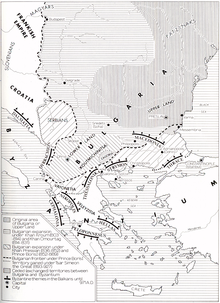
Fig. 2. Ethnic and political changes
in the Balkans from A.D. 800-972.
In addition one may confirm the subdivision of Bulgarian land into three parts in the Middle Ages by the List of Bulgarian Archbishops of the twelfth century (also known to scholars as the Catalogue of Du Cange). In it there is a report that Prince Boris I dispatched Clement of Ochrida as a bishop of Tiberiople (modern Stroumitsa, Yugoslavia) and Velikia, [28] charging him to supervise also the third part of the Bulgarian Kingdom, i.e. from Thessalonica to Herissos and Canina or Tassipiyat. [29] Herissos is located – the Chalkidike Peninsula, and the latter, on the coast of the Adriatic Sea. If this report uses the popular division into 'Upper' and 'Lower' land, then obviously the third part is the 'Lower land’, called thus in other script monuments.
It is feasible to assume that the shaping of the three parts was linked chronologically with the great expansion of the Bulgari empire. The first was 'Upper Bulgaria', the initial territory of the state with the capital at Pliska, and later Preslav. It incorporated Moesia with the part of Thrace already conquered. The second part was 'Trans-Danubian Bulgaria', a large portion of which, far as the middle reaches of the Danube, was annexed by the khan Kroum and Omourtag early in the ninth century, after the downfall of the Avar Khaganate and the division of its territory between Bulgaria and the Frankish Empire. The third, greater enlargement of Bulgaria came with the unification of the kindred population of ancient Macedonia and the greater part of modern Albania. This took place towards the middle of the ninth century.
It is known from I.egenda Bulgarica by Theophylakt of Ochrida Bulgaria's Archbishop, that during the reign of Prince Boris I (852-889) the south-eastern part of the Bulgarian Empire called Koutmichinitsa, the Byzantine transcription of a Proto-Bulgarian word, meaning 'newly-acquired' or 'newly-annexed’ land. In view of the rapid expansion of the Bulgarian Empire, that name soon lost its meaning and was replaced by the names of the main towns of the new arrivals, i.e. Devol, Stroumitsa, etc. [30]
The traditional and popu1ar division of Bulgarian lands was retained even after mediaeval Bulgaria ceased to exist. The tradition was preserved also in the coat of arms in its last dynasty, that of the Shishmans: three lions, placed one above the other, as symbols of every part of Bulgaria's domains. Subsequently, in designing the coats of arms of the three main Bulgarian regions: Moesia or Bulgaria, Thrace and Macedonia, the three lions were separated, each forming a basic element, in accordance with the common practices of heraldry. Again three similar symbols – greyhounds – also appeared in the coat of arms of Bulgaria in a heraldic inventory of Hungary in 1766. [31]
In A.D. 1018 Bulgaria fell under Byzantine domination. With the downfall of the First Bulgarian Empire, the barrier which checked the raids by the Turkic peoples, such as the Patzinaks, Uses, etc. at Europe's eastern gate, also disappeared. The military and administrative structure of Bulgaria's territories, conquered by Byzantium, was evolved in view of the new tasks: to make secure the north-eastern realm of the Empire. The themes of the Danubian towns Paristrion and Sirmium were created from the two ancient Moesias in the Upper Land. The Western part of Trans-Danubian Bulgaria fell under the rule of the Magyars, while Byzantium held a part of the eastern territory for a short while. Thus, in present-day Bessarabia, between the rivers Proutul and Dnjestre, the theme Mesopotamia of the West, was set up. It disintegrated, however, in the first decades of the eleventh century under the blows of the invaders from the East. [32] The Lower Land, where towards the end of its existance after the capture of the capital city Preslav in A.D. 972, the centre of the Bulgarian state was transferred to Ochrida, a new Byzantine theme was established with Skopije as its centre (Fig. 3). It alone retained the name of the conquered state – Bulgaria. The seat of the Bulgarian Patriarchate, transformed by the conqueror Basil II Bulgaroktonus into an autocephalous Bulgarian Archbishopric, remained in Ochrid.
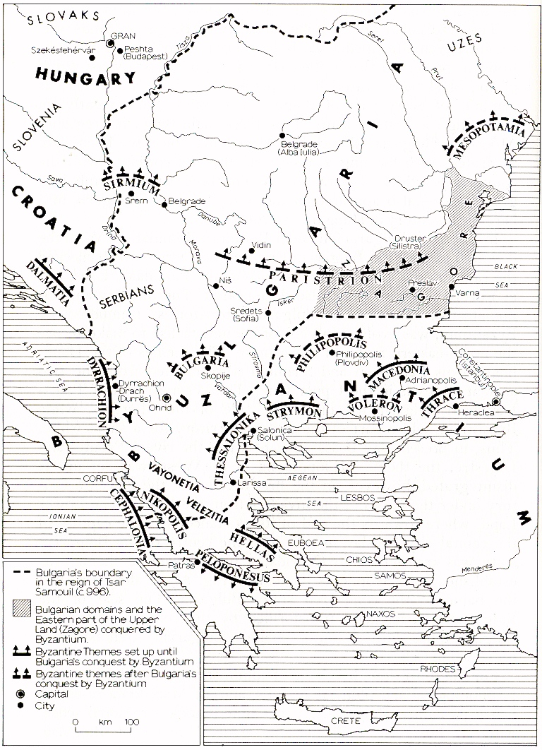
Fig. 3. Political changes in the Balkans,
A.D. 972-1185.
For the third time, by virtue of administrative decisions and for terminological and political reasons, ancient Macedonia re-established its name – Bulgaria. At that time it took a regional sense, without, however, replacing the general name of Bulgaria, existing simultaneously with it, or the archaized Byzantine term of Moesia, in the sense of the lands, inhabited by a Bulgarian population. The Bulgarians, however, stuck to the division of their homeland into the customary three parts.
There was a change with the restoration of the Bulgarian Empire in 1185. Its centre again returned to the Upper Land, and Turnovo became the capital city. From the viewpoint of the population of the Lower Land (i.e. ancient Macedonia), as well as that of the Byzantine themes Macedonia and Thrace the Upper Land was called Zagore. (Note that the regional name Zagore was given to land which was inhabited by a homogenous population, which, however, was separated by a mountain, serving as a frontier.) This was possible, after its fall under Byzantine rule in 972. At that time, mountain massifs, serving as frontier areas with the Byzantine Empire, separated it from Bulgarian lands, with a state centre in Ochrida, which remained free and independent until A.D. 1018. Being a shorter term, Zagore was the preferred form and a synonym of the Upper Land or Upper Bulgaria for the inhabitants of the Lower Land.
After Turnovo was proclaimed capital and the seat of its Archbishop
(and later Patriarch), the rulers and the head of the Bulgarian Church
acquired the name Zagorski or Zagorian. This name would have been widely
used in the spoken language, by the people and for this reason it was adopted
by the authorities as well. [33] The name Zagore, given
to the heart and centre of the Second Bulgarian Empire by the inhabitants
of the Lower Land, was taken up also by the neighbouring peoples. As early
as the thirteenth and fourteenth centuries it was adopted by Serbians,
Italians, Byzantines, and later also by the Ottoman Turks during their
invasion of the Balkans. Thus Zagore became the synonym of Bulgaria in
general and acquired a secondary meaning. [34] In the
Late Middle Ages, the term passed into Italian cartographic images of the
Balkans and then was used in some German and other maps. [35]
The Ottoman conquest of the Balkans found regional names, well established among the local population, which had formed as a result of ethnic changes and the political state of affairs in the Middle Ages (Fig. 4). The name Bulgaria was retained along with that of Lower Land, Lower Bulgaria or Lower Moesia, respectively, chiefly for the western territories, [36] ancient Macedonia, populated by Bulgarians. The north-eastern parts were called Zagore or Upper Land (Upper Bulgaria), [37] while the basin of the River Maritsa in ancient Thrace, in accordance with the Byzantine theme structure, was called Macedonia. Owing to the long duration of Bulgarian rule over its northern and western parts, it was known as Bulgarian Macedonia. [38] South-eastern Thrace (which was the only one to retain the name of the ancient province, Thrace, thanks to the Byzantine theme of the same name), as well as the Adrianople area were also called Romania, because of their prolonged affliation to the Empire. In fact, the Ottoman Turks, on reaching the Balkans, clashed with the Byzantines and for this reason they called the territories conquered by them, Rum-ili or Roman Land; later this was a general name for their other European domains. It is from this term that the later west European one, 'Rumelia', was derived. By a religious criterion that name was given to all lands inhabited by Eastern Orthodox Christians in the central and eastern parts of the Balkans belonging to the sultan's realm. The Ottoman Sultan placed them under the Greek Patriarchate of Constantinople, which had abolished the Turnovo Bulgarian Patriarchate towards the end of the fourteenth century.
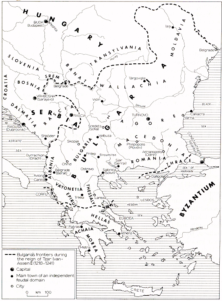
Fig. 4. Names of regions and countries,
established during the Second Bulgarian Empire.
Some of the small independent states, set up after the decline of the central power in Byzantium and in Bulgaria introduced new names to countries, such as Wallachia, Albania, etc. The former came into being as a state in the fourteenth century in a part of Bulgaria's territories across the Danube, when its Second Empire was in the period of feudal dismemberment.
The rule of the sultan could not impose new names on regions and areas by its imperial organization, and to a large degree, the latter conformed with the territories of the separate feudal possessions, and not with the nations inhabiting the Balkans. Fortresses, near which decisive battles were fought during the conquest of the peninsula, were selected for centres of the sanjaks. The fortresses lent names to the administrative unit, e.g. Nicopolis Sanjak, in which the territories of the Turnovo Tsardome to the north of the Balkan Mountains at its subjugation were incorporated; the land of the Dobroudja Principality was included in the Silistra Sanjak; the domains of Tsar John Sratsimir – in the Vidin Sanjak; those of the Dragash despots – in the Kyustendil Sanjak, etc. [39] As in the Middle Ages administrative units that were named after their town-capitals, without taking into account thg ethnical composition of the population, could not form durable toponyms. It is for this reason, that, even after both Bulgarian and Byzantine administrative organizations were destroyed, the traditions of mediaeval regional, geographical nomenclature were not impaired in the concepts and consciousness of the indigenous population.
Both monuments in local script and a number of foreign observer-travellers in the fifteenth to eighteenth centuries bear testimony to the preservation of the names of regions and areas, established during the Middle Ages. The majority of travellers passed along the old military highway from Vienna via Belgrade and Sofia to Constantinople. Those that had closer contact with population report that after crossing the Rivers Morava and Nish, they entered 'Bulgaria', and after the mountain pass 'Trajan's Gates into 'Macedonia' with its main towns Philippople and Adrianople. [40]
These local traditions of the Middle Ages, however, clashed with the concepts in theWest concerning the names of countries and of the population in south-eastern Europe. These concepts were formed under the influence of Renaissance ideas, and as result of the respect held by cartographers for the traditions of the Roman provincial structure. Also, the names of the Roman ministrative nomenclature were not fully effaced from mediaeval maps of the world, where the Roman provinces continued to be marked, along with certain new facts and changes that had taken place after the downfall of the World Empire. [41]
Christians in Western Europe had incomplete and sparse information on the Balkan Peninsula, and on its interior regions in particular, owing to its almost entire isolation. They believed that the descendants of Greeks, Thracians, Dacians, Macedonians and Illyrians still lived there, but that their religion was 'Greek', i.e. Eastern Orthodox. Thus, they continued to call by their ancient names those inhabitants of the Balkans who were oppressed and stereotyped under the Ottoman yoke. For people who were imbued by humanistic ideas, these countries were veiled in mystery and were adorned in the imagination with the beauty of Antiquity and the attractiveness of Eastern exotics. In Western Europe, the classical geographers enjoyed an irrefutable prestige. Thus, more modern times, the traditional Roman geographical nomenclature was not only retained, but found fresh arguments in Claudius Ptolemy's Cosmography. For a long time, it remained the main source of information on the state of affairs in that part of the old World. As a consequence, the names Thrace and Macedonia covered areas, both in the literature and the cartography of western Europe, they had in Antiquity. In the Balkans, there had been little progress since the second century A.D., when they were described by the Alexandrian cartographer. [42]
'Moesia', which was not related to an ancient ethicon, was replaced by 'Bulgaria' in the mediaeval tradition, as there was information about the existence of such a country and people. However, only the space between the Balkan Mountains and the Danube was left and allotted to them, after the map had been divided into the countries of the glory-covered Macedonians of Alexander the Great and of the Thracians of Orpheus. Thus, in the maps of more modern times, three provinces, actually non-existent in the Ottoman administrative structure, are formed in the central and eastern parts of the Peninsula. In fact the inhabitants of these regions held totally different concepts of the locations and scope covered by these names. [43]
Towards the middle of the nineteenth contury, modern geographical science
undertook a systematic study of the unknown hinterland of the Balkans.
These investigations helped in the gradual dissipation of stratified delusions
that they formed a 'Hellenic world' and a 'Greek Peninsula', both ethnically
and culturally. The discoveries, however had no effect on the widespread
use of an ancient regional nomenclature in free Europe. [44]
In spite of everything, it remained valid and unaltered. Moreover, step
by step, after relations with Western Europe and the penetration of its
civilization became brisker, the peoples, subjugated to the Sultan, began
to hear of this nomenclature and it was adopted by the indigenous population
although the mediaeval names and meanings were lost.
9. Notes1. Since the reign of Emperor Aurelianus (A.D. 270 – 275) Dacia has been situated to the south of the Danube, where a considerable part of the population of Trajan's Dacia fled after the invasion of the Carps in A.D. 245. A similar instance of shifts of names of countries is the case of Moesia in Asia Minor, where a part of the Thracian tribe of the Moesians resettled from the Balkan Peninsula. As a rule, countries' names are in a definitive relationship with those of their inhabitants and follow their settling in domiciles.
2. The barbarian invasions and the settlement of the Slavs is abundanty elucidated in the general course of Byzantine and Balkan history.
For greater detail on the penetration of the southern Slavs into modern Greece and Albania see:
А. М. Селищев, Славянское население в Албании. София (1931);
L. Niederle, Manuel de l'antiquite slave. Paris (1939);
M. Vasmer, Die Slaven in Griechenland. Berlin. APAW, Philos.-hist. Klass. No. 12 (1941);
P. Lemerle, 'Invasions et migrations dans les Balkans depuis la fin de l'epoque romaine jusqu'au VIIIe siecle'. Revue Historique CCLI (April-June, 1954), 270 et seq.;
Д. Ангелов, Образуване на българската народност. София (1971), pp. 141 et seq.3. See Д. Ангелов, op. cit. (1971), pp. 108 et seq.
4. For the areas of settlement of the two South-Slavonic groups (the Serbo-Croatian and the Bulgarian) see
L. Niederle, La Race Slave. Statistique, antropologie, demographie, Paris (1916), and especially the map supplied by him, giving the state of settlements in the seventh to eighth centuries. The distribution of the ethnical groups on the Balkan Peninsula is given at the time of their establishment and the formation of Slav nationalities and the boundaries of the spread of South-Slavonic languages are indicated there.5. In addition to references in note 9, see also:
Ив. Д. Шишманов, ‘Славянски селища в Крит и другите острови’, Български преглед, 4 (1897), 97 et seq.;
P. Charanis, 'The chronicle of Monemvasia and the question of the Slavonic settlements in Greece'. Dumbarton Oaks Papers 5 (1950), 89-166;
A. Bon, Le Pelopondse byzantin jusqu'en 1204. Paris (1951).6. Miracula Sancti Demetrii, II, V, 197.
7. L. Niederle Manuel, op. cit. I, 104-105.
8. One can judge the status of Slavonic territories, after they were reconquered by Byzantium from the report of Emperor Constantine VII Porphyrogenit in De administrando imperio ed. by Gy. Moravcsik and R. J. H. Jenkins, Budapest (1949 ), 50, 1-180, p .232. The Morean Sclavinians were described as 'independent' and 'autonomous and self-ruling'.
9. В. Н. Златарски, История на българската държава през средните векове, Vol. I (1), (1918), pp. 17 et seq., 136, 160 etc.;
П. Мутафчиев, История на българския народ, Vol. I, (1918), pp. 82, 144, 160 etc.;
F. Dvornik, Les Slaves, Byzance et Rome au IXe siecle. Paris (1926), pp. 12 et seq.;
Idem. Le legende de Constantin et de Methode vue de Byzance. Prague (1933), pp. 15 et seq.10. Ив. Дуйчев, ‘Славяни и първобългари’, Известия на Института за българска история, Vols 1, 2 (1951), pp. 197 et seq.
11. See Fr. Doelger, Ein Fall slavischer Einsiedlung im Hinterland von Thessalonike im 10. Jahrhundert, Sitzungsberichte der Bayerische Akademie der Wissenschaften, Philosoph.-historiche Abteilung I (1952), 25 et seq.
12. Theophani Chronographia, rec. C. de Boor, vol. I, Leipzig (1883), pp. 364, 480, 486 etc.
13. Ив. Дуйчев, ‘Нови житейни данни за похода на Никифор I в България през 811 г.’ Списание на БАН, LIV (1936), 149-150;
Scriptor Incertus de Leone Armenio, Leonis Grammatici Chronographia, rec. J. Bekkeri. Bonn (1958), p. 847.14. For the use of the names 'Moesians' and 'Moesia', meaning 'Bulgarians' and 'Bulgaria' see Gy. Moravcsik, Byzantinoturcica, II, Berlin (1958), 907-908.
15. Nicephori i archiepiscopi Constantinopolitani Opuscula Historica, ed. by C. de Boor, pp. 66, 56;
Theophani Chronographia, p. 430 etc.
The first to attract attention on that report was G. Cankova-Petkova, 'Bulgaria and Byzantium during the First Decades after the Foundation of the Bulgarian State', Byzantinoslavica, XXIV (1), Prague (1969), 41-58.16. In accordance with the explicit mention of Constantine Porhyrogenitus in his work De thematibus ed. by A. Pertusi, Studii e testi, No. 160. Citta del Vaticano, No. 86 (1959).
D. Obolensky, The Byzantine Commonwealth, Eastern Europe, 500-1453. London (1971), pp. 76 et seq.;
N. Oikonomides, Les listes de preseance byzantine de IXe et Xe siecles. Paris (1972), pp. 76 et seq.17. Г. Острогорский, ‘Постанак тема Хелада и Пелопонес’, Зборник радова САН, I, (1959), 64-76.
18. П. Коледаров, ‘Образуване на тема Македония в Тракия’, Известия на Института за история, 2l (1970), 222 et seq.
20. P. Koledarov, On the initial hearth of Bogomilism, in Materiaux du symposium international ‘Tirnovo et l’Etat bulgare meyengeux - centre de mouvements heretiques’ (XII-XIV s.), V. Tirnovo (1973).
21. Georgii Hamartoli Chronicon (ed. by E. de Muralt, Petropoli (1859), pp. 724-725.
22. In the Old-Bulgarian translation of Legenda Ochridica by Demetrius Chomatianus, Archbishop of Ochrida, written early in the thirteen century, 'Thessaly' is translated as the 'Thessalonica area'. Obviously, in the minds of mediaeval Bulgarians Thessalonica was the centre of Thessaly and not of Macedonia. The theme 'Macedonia' of that time had its centre in Adrianople.
23. The ancient meaning of the name 'Macedonia' was preserved only in parchment manuscripts and maps in the Middle Ages, to reappear again from time to time as a parachronism. Only the more conservative-minded ecclesiastic circles, and occasionally single members of the Byzantine literary circle used it for a couple of centuries after the setting up of the themr 'Macedonia' in Thrace. These are mostly cases when they were forced to use the term at times of ultimate danger for their homeland, Byzantium, in order to produce arguments in support of their claims on ancient Macedonia and to draw on its grandeur and might. They took the ancient Kingdom from oblivion with the aim of stimulating the patriotic feelings of the population of the Empire, but even in such cases, the name 'Macedonia' had only a regional and geographic content, and not an ethnic one.
Many of these writers, when they archaize, deem it necessary to explain what they have in mind, namely the ancient Macedonia, and not the contemporary one. This is the case for instance with Anastasius the Librarian (in Vita Hadriani II, 636), and Theophylact of Ochrid, Archbishop of Bulgaria (in the Vita of the Tiberiople martyrs – J. P. Migne, PGr, Vol. 126, col. 151). The theme 'Macedonia' imposed its name to such a degree on Byzantine everyday life that, in certain cases, it became the cause for retrospective actualization: in its mediaeval scope and location the name 'Macedonia' was transposed to the events that took place prior to the formation of the theme, and in fact in the'confines of Thrace in Antiquity.
24. P. Koledarov, 'More about the Name "Zagore". Bulgarian Historical Review, 4, (1978 ), 100, 106.
26. Thus, for instance, in the Turkmenian language the word ‘okari’ denotes, 'East', i.e. the point where the sun rises, and 'oshag' denotes 'West', i.e., where the sun sets. See Е. М. Мурзаев, ‘Основные направления топономастических исследований’ in Принципы топонимики, Москва (1964), p. 81.
Even today in Bulgarian dialects the East Wind is called Gornyak i.e. coming from the Upper Land (Gorna zemya), while the West Wind is the opposite, ‘Dolnyak’, coming from the Lower Land (Dolna zemya).27. It is found, for instance, in the deed of King Constantine Asen (1251-1277), granted to the monastery of Virginsko Burdo near Skopije, in the Old-Bulgarian translation of Manasses' Chronicle and other Bulgarian documents of the Middle Ages.
28. According to reports by Theophylact of Ochrida in Legenda Bulgarica, as 'First Bishop in the Bulgarian language of the Dragouvites and of Velikia'. See quotations in П. Коледаров, ‘Климент Охридски, "Първи епископ на български език" на драгувитите в Солунско и на Великия в Западните Родопи’ in Константин-Кирил Философ, София (1969), pp. 160-161.
31. Francisco Carolo Palma, Heraldicae regni Hungariae spesimen, Vienna (1766). The Proto-Bulgarians held the lion and the dog as sacred animals.
32. For the Byzantine theme across the Danube see Ив. Божилов, ‘Към въпроса за византийското господство на Долни Дунав в края на X в.’, Studia Balcanica, 2 Sofia (1970), 81-95;
Oikonomides, op. cit., pp. 268, 269, 363.33. P. Koledarov, op. cit. (1973a), pp. 100-102.
35. Ibid. pp. 104-105. Idem. 'The Bulgarian State in Medieval Cartography' in Etudes historiques, Vol. IV (a 1'occasion du VIIe Congres international des etudes slaves – Varsovie), Sofia (1973), p. 48.
36. For the use of the terms by Bulgarian men-of-letters in Macedonia in the nineteenth century see P. Koledarov, op. cit. (1969), pp. 161-162.
37. P. Koledarov op. cit. (1978a), pp. 100 et seq.
38. See, for instance, the Dechani Synodikon of the twelfth century in В. А. Мошин, ‘Сербская редакция Синодика в Неделю православия’, Византийский Временник XVII (1960), 347-348.
39. See П. Коледаров, ‘Към въпроса за развитието на селишната мрежа и на нейните елементи в средищната и източната част на Балканите от VII до XVIII век’, Известия на Института за история, 18 (1967 ), 108.
40. Certain instances for such testimony and findings are given in P. Koledarov op. cit. (1970), p. 239, footnote No. 18.
41. See P. Koledarov, op. cit. (1973a), pp. 37-51.
42. For greater detail see P. Koledarov (1973). 'Traditions of antiquity and the Middle Ages in the regional nomenclature in the modern map of the Balkans', Byzantinobulgarica, IV, 171-174.