30. The ethnological map by the Bulgarians Professors (1912)
31. The Bulgarian Exarchate (1870-1912)
32. Bulgaria according to the European Conference (1876-1877)
33. „ „ „ „ Prince Tscherkasky (1877)
34. „ „ „ „ the Treaty of St. Stefano (1878)
35. „ „ „ „ Berlin Treaty (1878)
36. The Union of the two Bulgarias (1885)
37. The map of the “Disputed Territory” (1912)
38. The Balkan map after the War against Turkey (1912-1913)
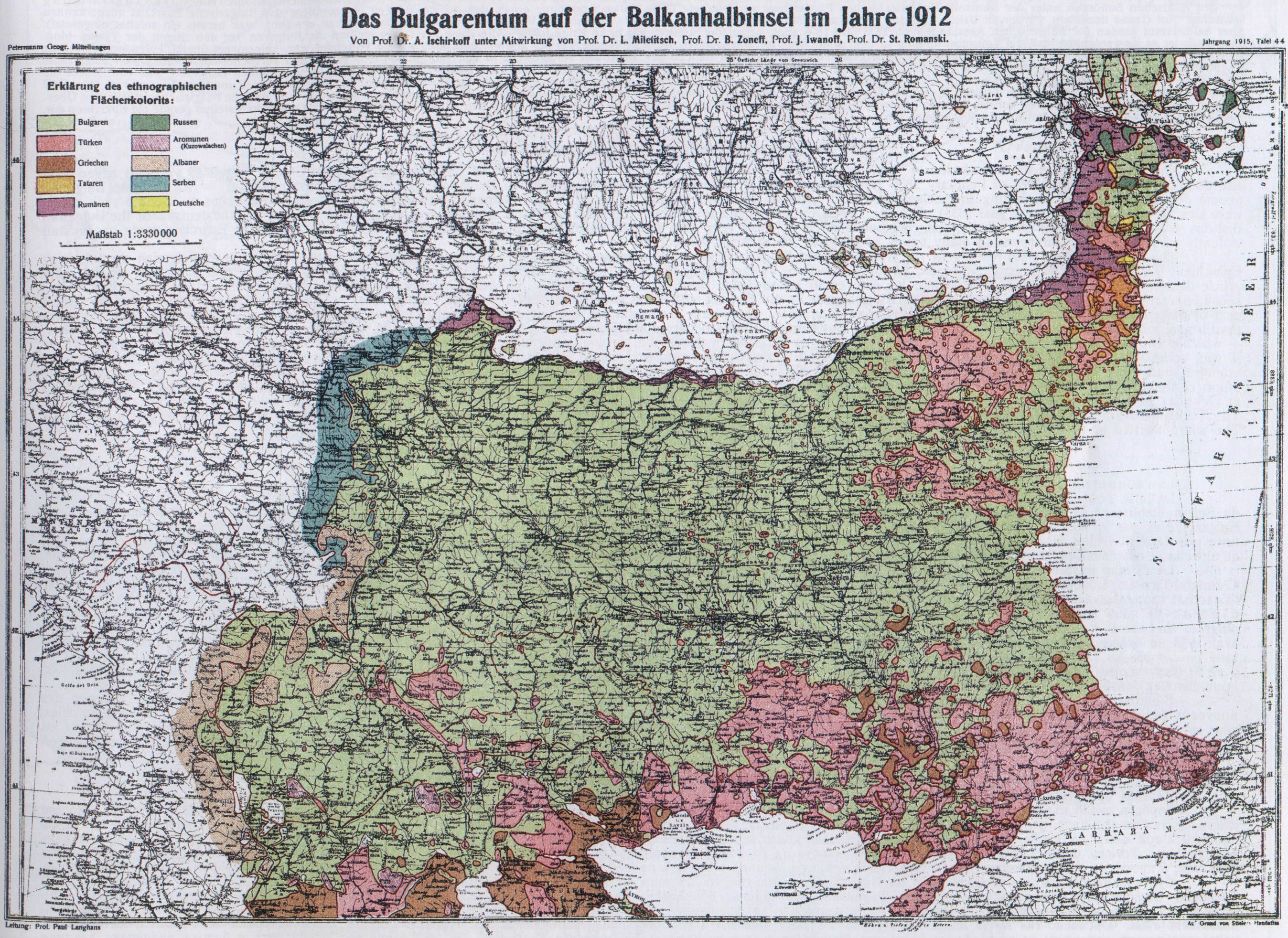
30. — The Ethnological Map by the Bulgarian Professors (1915).
This map too is a Bulgarian one. It shows the extension of the Bulgarian people on the peninsula before the Balkan-war of 1912. During this war and afterwards, certain ethnological changes have taken place in Macedonia and Thracia. This map is elaborated by Dr. A. Ischirkoff, Professor of Geography at the Sofia University, with the assistance of four other professors. Ischirkoff himself, drew the ethnological map of the Bulgarian Kingdom in its old boundaries (until the year 1913) according to official statistics; Professor Dr. Miletitsch — that of Thracia; Professor Jordan Ivanoff — that of Macedonia; Professor Dr. S. Romansky — that of the Dobrudja; and Professor Dr. B. Zoneff has represented the expansion of the Bulgarian people in the river-basins of the Bulgarian Morawa and the Timok relying chiefly on linguistic argumentation; he added to the map an explanatory note determining the boundary between Servians and Bulgarians by the spoken longue. The map has been published in „Petermanns geographischen Mitteilungen” 1915, table 44.
We cannot sufficiently regret that want of space in the atlas necessitates such a diminution of the map as will make its use without a magnifying glass scarcely possible; but as for the maps by Hahn and Kantschoff, we hope that the reader will take the trouble to find himself aright on this map too. These three maps are worth this trouble.
53
![]()
( 30. — The Ethnological Map by the Bulgarian Professors (1915) )
54
![]()
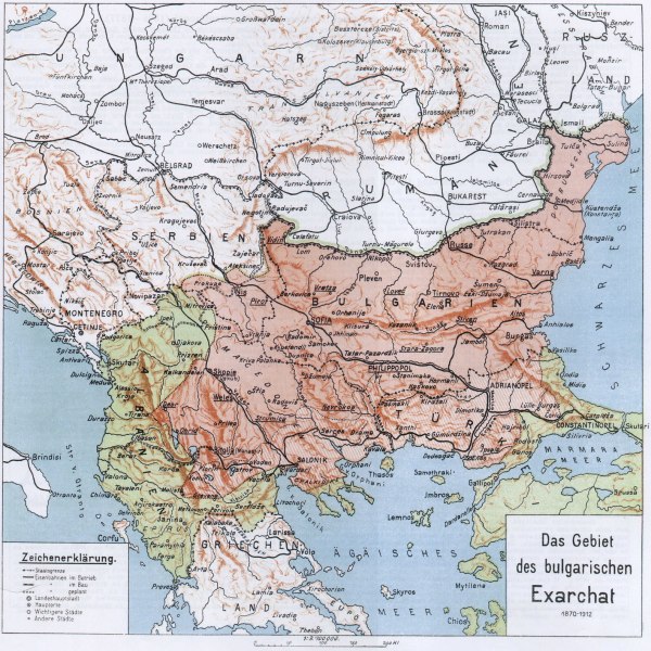
31. — The Bulgarian Exarchate (1870—1912).
This map represents the boundaries of the Bulgarian Exarchate. — The quarrel about the erection of the Bulgarian National-Church lasted 40 years; it began 1830 and found an end on the 28th of February 1870 (ancient style) by a Turkish Firman which erected the Bulgarian Exarchate at Constantinople. — At first the Bulgarian people demanded the right of electing themselves their own bishops, who should have to belong to the Bulgarian nationality too. — The first towns to declare such desire were Uescub and Samokov (in the year 1833). But the Greek Patriarchate was decidedly opposed to it and the controversy took two new forms: the demand of the Bulgarian Bishops was increased with the desire for religious service of their own and schools of their own, — the Greek Bishops in the Bulgarian Eparchies were openly and violently persecuted. This happened in many towns of Bulgaria, Thracia and Macedonia.
The Firman of the Sultan relating to the erection of the Bulgarian Exarchate, expressly denominated in the first paragraph of the 10th article as Bulgarian the following Eparchies: Rustschuk, Silistra, Varna, Schumen, Tirnovo, Lovetsch, Vratza, Vidin, Sofia, Kiustendil, Samokoff, Nisch, Pirot and Veless; the second paragraph of the same article decides that other Eparchies too should be allowed to acknowledge the Exarchie if at least 2/3 of their Christian inhabitants should demand this. According to this second paragraph of the Firman a „people's-vote” was made by the Turkish authorities under control of the Greek Patriarchate. — This „people's-vote” proved that the largest part of Macedonia wanted to acknowledge the Bulgarian Exarchate, whereupon bishops were appointed for Uescub, Ochrida and Monastir; (for Veless, expressly named in the Firman, such appointment had already taken place). But soon after this occurred the Bulgarian insurrections of 1875—76, which were followed by the Russo-turkish war, — which events exposed the Bulgarians in the eyes of the Turks. Thanks to these, the „people's-vote” could not be completed in the southern part of Macedonia and, where it was completed, Bulgarian Bishops were not appointed in all of these Eparchies; and where such had tried to go, they were thence driven away by the authorities. The attempts made 1884/1885 to send Bulgarian Bishops in Macedonia failed on account of the protest of the Greek Patriarchate, of Servia and of Greece. Soon after came the union of the two Bulgarias which newly compromised the Bulgarians in the eyes of the Turks. Only in the year 1890, new Bulgarian Bishops were appointed at Ueskub and at Ochrida; in the year 1894 bishops came to Veless and Nevrokop, and 1897 to Monastir, Debar and Strumitza. The other Eparchies never had any Bulgarian Bishops. The Turkish Government only allowed the bulgarian clergy of these Eparchies to represent the Bulgarians before the local authorities and to manage their own school-matters. The white-hatched places on the map denote those Eparchies that did not get Bulgarian Bishops.
55
![]()
( 31. — The Bulgarian Exarchate (1870—1912) )
56
![]()
32. — Bulgaria according to the European Conference at Constantinople (1876—1877).
In consequence of the Servian insurrection of 1875 in Bosnia and Herzegovina, of the insurrections which the Bulgarians made 1875 and 1876 in Thracia, and the war following between Servia, Montenegro, and Turkey in Dezember 1876, — a conference was held at Constantinople in order to discuss the conditions of peace and to grant independent administration to Bosnia, Herzegovina, and Bulgaria.
Concerning Bulgaria the Conference decided to divide it vertically into two provinces: — an east-province with Tirnowo as capital, and a west-province with Sofia as capital, granting them self-administration and placing them under control of a general international commission. The idea of dividing Bulgaria perpendicularly was promoved by England who beleived that the Turkish and Greek elements would gain the upperhand over the Bulgarian elements in the Bulgarian east-province, and that by this means Russia's road to Constantinople would be intercepted.
A special attention is deserved by the following declaration made by the Marquis of Salisbury at the session of January 8th 1877: „It was not possible to submit to the consideration of the Conference, under the name of Bulgaria, the districts where the Bulgarian population did not predominate, nor those districts which have not been exposed to the bad government which gave rise to the excesses committed in the course of last summer.” (See: the English Blue-Book № 2 (1877) entitled: Correspondence respecting the Conference at Constantinople and the affairs of Turkey: 1876—1877, Page 340). That means: Inside the boundaries of both these independent provinces was not included the whole ethnological Bulgaria but only those parts of it where the Bulgarians had the majority, and which were the objects of the well-known Turkish excesses of the summer 1876. In spite of all this, both independent Bulgarias created in this way comprise — as a glance at the map shows — the whole Dobrudja, the whole district (Sandjak) of Nisch with the cities Vranja and Pirot (the latter city is not denoted on the map but it is notorious that it lies east of Nisch), the whole Sandjak of Uescub (even the small town Katschanik, the gate to the Schar-Planina included), and the towns Kostour (Kastoria), and Lerin (Fiorina) with their districts (Kaaza).
We take this fac-simile map, from the English Blue-Book № 13 (1878) entitled: „Further Correspondence respecting the affairs of Turkey. (With Maps of proposed Bulgarian Vilayets)” — To judge by the negligence with which this map has been drawn it is not difficult to see that it is the work of diplomats whose strong side is not the art of map-drawing.
57
![]()
( 32. — Bulgaria according to the European Conference at Constantinople (1876—1877) )

58
![]()
33. — Bulgaria according to Prince Tscherkasky (1877).
This map does not exist in original; it was drawn by Professor Ishirkoff on data and informations given by Prince Tscherkassky (Civil-Governor of Bulgaria at the time of the Russian occupation) to the Russian Minister of war. In his report Tscherkassky asserts that the Bulgarian frontiers run as follows: „West — along the line approved by the Russian Emperor, Alexander II (this line — as declares the Russian Major-General Owssjani in his book: „The Russian Administration of Bulgaria in the Years 1877-78-79. St. Petersburgh, 1906, vol. 1”, — included the towns Nisch, Kurschumliе, Lesskovetz, Pristina and Prisren); South: from Mount Pind along the river Bistritza (Indje-Karassu) down to the Bay of Salonica, from there through the peninsula of Salonica (Halkidika) in the direction of the Agean-Sea, leaving the city of Salonica and the Beschik-Sea inside of the Bulgarian frontiers; further on, along the coast towards the mouth of the river Maritza, and thence along the course of this river to that point, where the river Ergene flows in it; the frontier goes further along the course of the Ergene and its afflux, Tschorlu-Dere, to the ridge of the Strandja Pianina and along its crest to Anasstasieffs-wall, called Constantinople-Territory; East: along the shores of the Black-Sea; North: along the Danube”.
We publish this map as a proof that Russia originally thought of giving to Bulgaria those frontiers which were approved by the emperor himself (at least those in the west), whereas the treaty of St. Stefano reduced them considerably. Servia received the towns Nisch, Kurschumlie, and Lesskovetz that had been already occupied by her, as a territorial indemnification for her partaking at the Russo-Turkish war; in this way Servia got at that time these Bulgarian towns and their surrounding districts, not because she had any ethnological or historical right upon them, but only on purely political considerations: — because Russia had to indemnify Servia for her partaking at the war, and because such compensations could not be given by Russia on the Kossovo-Pole without arming Austro-Hungaria against herself. As we shall see further down in our work, Servia succeeded at the Berlin Congress of 1878, with the aid of Austria-Hungary, to acquire also the Bulgarian towns Vranja and Pirot as well as the surrounding country.
59
![]()
( 33. — Bulgaria according to Prince Tscherkasky (1877) )

60
![]()
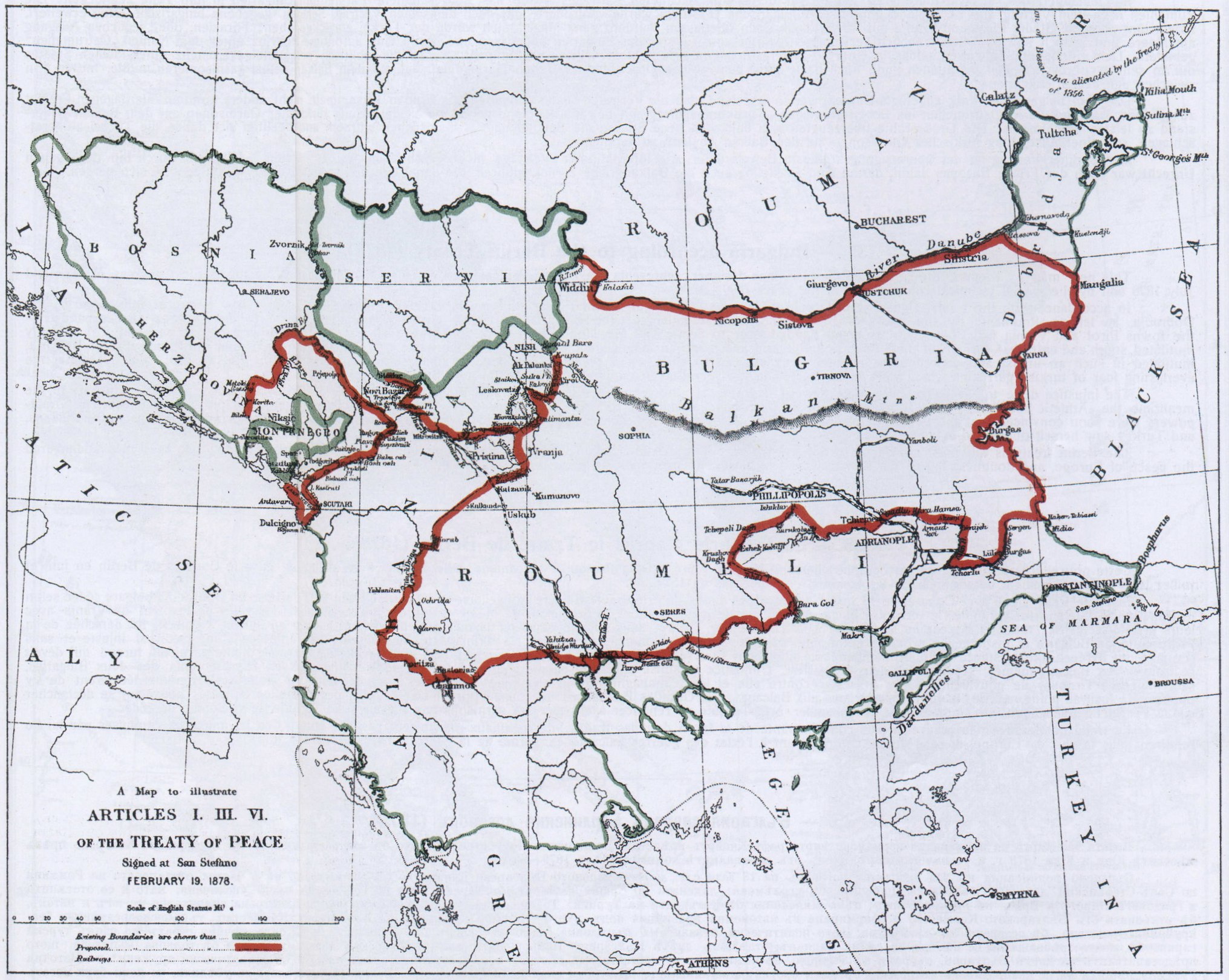
34. — Bulgaria according to the Treaty of St. Stefano (1878).
This map depicts the boundaries of the Bulgarian Principality according to the treaty closed between Turkey and Russia at St. Stefano on February 19. 1878 (a.s.) These boundaries do not by any means comprise the whole ethnological expansion of the Bulgarian people. Thus: the largest part of the Dobrudja was at that time ceded by Russia to her ally Roumania as territorial indemnification for Bessarabia that had been taken from Roumania, whereas the cities Nisch and Lesskovetz had been given with their country districts to Servia for the latter's participation in the war against Turkey. But all the same, to the dominion of the newly created Bulgarian Principality belonged nearly all North-Bulgaria and the largest part of Thracia and Macedonia, with a western frontier including the towns Pirot, Vranja, Katschanik, Debr, Struga, Ochrida, and Kortscha; in the south, to the new principality belonged the towns Kostur, Voden, Enidje-Vardar, ihe mouth of the river Vardar in the very port of Salonica, Seress, Drama, Kavala, Mustafa-Pascha, Losen-Grad (Kirklisse), and Liule-Burgas; the south-eastern boundary touched the sea immediatly above the townlet Midia.
It can be easily understood that the liberation of Bulgaria made all the Bulgarians of that time so grateful to Russia that nobody thought of uttering a protest against her for the cession of Bulgarian territories to Servia and Roumania, but an open wound remained in all Bulgarian hearts for this loss, which wound was only healed in the years 1915 and 1916.
We copy this map from the English Blue-Book, entitled: „Turkey № 23 (1878). Maps showing the New Boundaries under the Preliminary Treaty of Peace between Russia and Turkey, signed at San Stefano, 19th February — 3rd March 1878.” The Bulgarian territories ceded to Roumania and Servia are very easely to be distinguished on this map.
61
![]()
( 34. — Bulgaria according to the Treaty of St. Stefano (1878) )
62
![]()
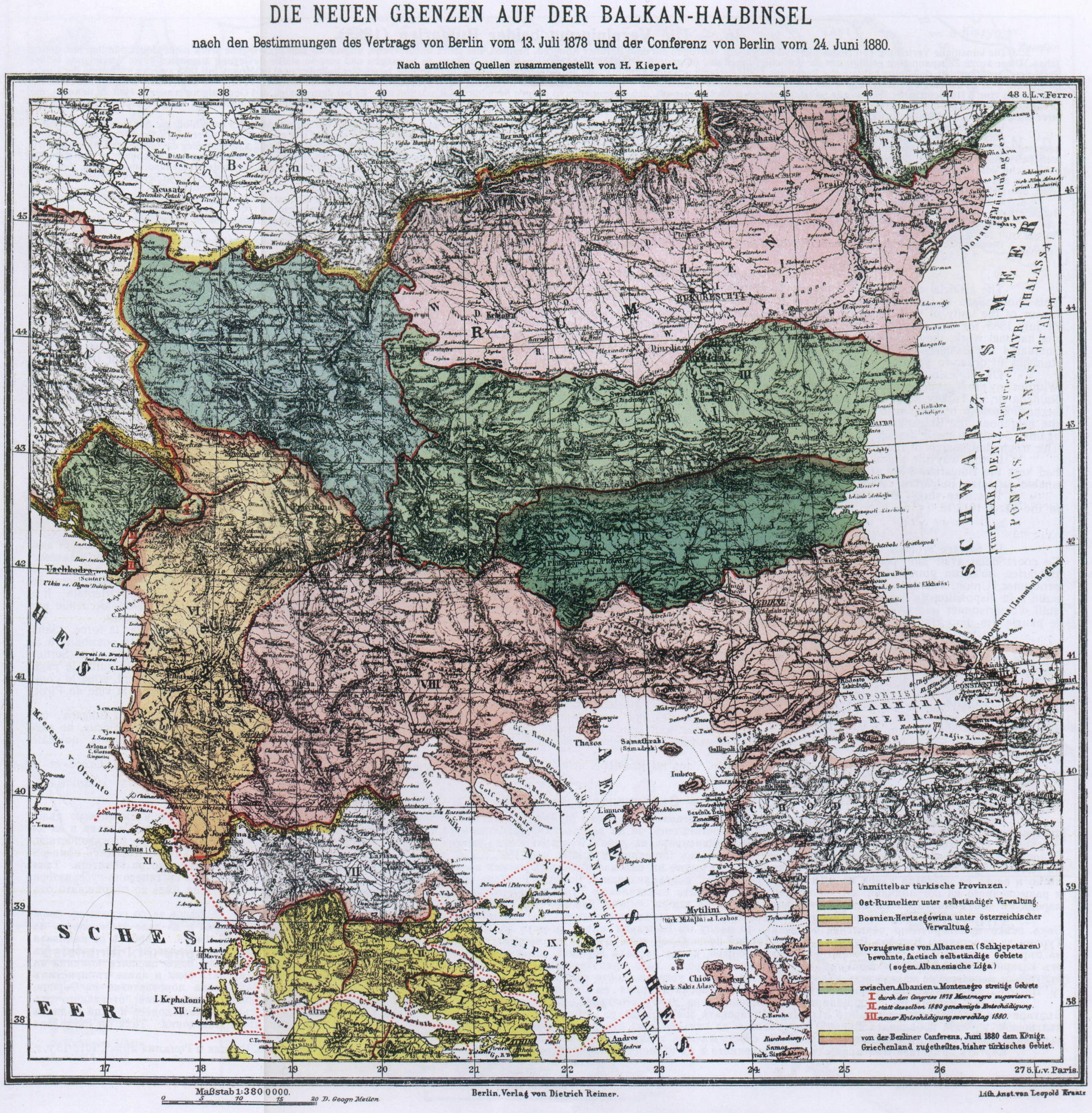
35. — Bulgaria according to the Berlin Treaty (1878).
This new map by Kiepert, the celebrated German map-designer, represents the Balkan Peninsula as fixed in her boundaries by the Berlin Congress of June and July 1878 and by the special technical commissions of the years 1879—80.
In accordance with the treaty, signed at this congress on the 13th of July of that year, the newly created Principality Bulgaria has been cut into 5 parts: the Dobrudja, as left to Roumania by the treaty of St. Stefano, became enlarged; the Bulgarian territory, given by the same treaty to Servia, was also expanded — the towns Pirot and Vranja with their districts being handed over to Servia; all Macedonia went back to Turkey; Thracia, being depriwed of any sea and, considerably mutilated south and east, was torn from the Principality Bulgaria and made an independent province under the name of „Eastern Rumelia”; and the Principality of Bulgaria, mutilated in such an unjust and unscrupulous manner, was allowed to exist, as a politically independent small state, only north of the Balkan Mts., and this under the everlasting fear of turkish garrisons which were to be located in the very Balkan mountains between the two Bulgarias.
The injustice done to the Bulgarian people was so flagrant that the representatives of the two Bulgarias, assembled at Tirnovo, had to protest against it; in the meantime the „Athletic batallions”, quickly called to life in East-Rumelia, decided to resist with arms to the settlement of Turkish garrisons on the Balkans. The Great-powers were soon convinced that the Balkan-Peninsula would be again visited by storms, and hurried to advise Turkey to abandon the dispatch of garrisons to the Balkans, and Turkey saw herself obliged to submit.
The Berlin treaty is the most convincing proof for the way in which international treaties should not be written. The wrong committed by it has endangered the peace of Europe, and doubtless led to the Balkan-wars which were the germ of the present Universal War.
63
![]()
( 35. — Bulgaria according to the Berlin Treaty (1878) )
64
![]()
36. — The Union of the two Bulgarias (1885).
The artificial division in North- and South-Bulgaria, accomplished at the Berlin Congress, like every unnatural, unjust and enforced work, lasted only seven years. This short space of time had been sufficient to strengthen the moral unity of the Bulgarian people on both sides of the Balkan and to develope such a strong movement in favour of the unity of both Bulgarias that no Bulgarian government could possibly stop it. And, when a secret committee of revolution, founded at Philippople in the month of July 1885 for the purpose of declaring the union of both Bulgarias, called upon the bulgarian officiers of the militia of East-Rumelia to take part with their troops in the national work, they at once put themselves at the disposal of the committee. Thus, easely and quickly, the blow of 6/18th September 1885 was prepared and struck, and liquidated the Eastern Rumelia in a few hours time. It was sufficient to arrest the Governor-General and to destroy the frontier-railwaybridge that joined Turkey to East-Rumelia, in order to proclaim the union which was greeted by the population of the two Bulgarias with an enthusiasm ready for every sacrifice necessary for its sanction.
Of all jealous neighbours of Bulgaria, who did not look upon the union of the two Bulgarias with pleased eyes, only Servia resolved to frustrate it by force. Without any previous declaration of war, Servia broke into Bulgaria in the night of the 1/13th November 1885 for the purpose of seizing Sofia and to enable Turkey to re-establish East-Rumelia or, if Turkey should not want that, to look after territorial indemnities for herself in Bulgaria. The Servians hoped to carry off an easy and quick victory, chiefly because Russian officers, who had been in charge of the high command in the Bulgarian army, had already left Bulgaria. But, outraged by the treacherous invasion of the neighbour, the Bulgarian people rose like a single man before his ennemy, and the Bulgarian army, under the high command of young Bulgarian officers threw itself against Servia in such assault that the Servian army, taken by surprise, was flung out of Bulgarian territory in 13 days, and the town Pirot was stormed and taken. The triumphal march of the Bulgarian army was checked by Austria, at that time the effective protector of Servia.
In this way the union of both Bulgarias was sanctioned and besides, brought an unexpectet benefit to the Bulgarian people: the recall of the Russian officers, who had kept the Bulgarian army at the disposal of Russia. As it happens with every extraordinary gain the union, too, was followed by mischief: — the vanquished Servia, unable to seize Bulgarian territory, cast her eyes upon Macedonia. Therefore the propagation of Servian ideas in Macedonia began in 1885.
This map shows Bulgaria after the union, and with her boundaries, as they remained up to the wars against Turkey, Servia, Montenegro, Greece, and Roumania in the years 1912/13.
65
![]()
( 36. — The Union of the two Bulgarias (1885) )

66
![]()
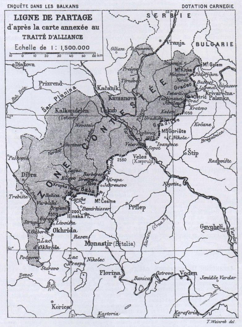
37. — The Map of the „Disputed Territory” (1912).
We borrow this map from the report of the well-known Carnegie-Commission of 1913 that made an inquiry into the outrages committed during the Balkan wars. Our reasons for publishing it are twofold: a) to make evident the boundaries of the so-called „disputed tentory” of Macedonia that should have been divided between Bulgaria and Servia according to the arbitration of the Russian Emperor, and b) in order to put an end to the Servian legend that all Macedonia is „disputed territory”. But we consider ourselves obliged to remark, that the map is not quite accurate concerning the western frontier, because the „disputed territory” ended behind the townlet Struga and comprised no territory west of the Ochrida-lake.
It must be known that according to Art. 2 of the „secret supplement” to the treaty of alliance between Servia and Bulgaria of the 29th of February 1912 (a. st.) Servia acknowledged Bulgaria's undisputed right i. e. “the territory east of the Rhodopies and the river Struma, whereas Bulgaria conceded to Servia the same right to the territory north and west of the Schar-Pianina. Concerning Macedonia, i. e. „the territory between Schar-Planina and the Rhodopies, the Archipelagus and Ochrida-lake” (quoting word by word from the „secret supplement”) Servia engaged herself, to attempt nothing this side of a line which separated the „disputed territory” from the rest of Macedonia. — The reader may convince himself of this, if he re-reads this treaty of alliance and its „secret supplement” in the French paper „Le Matin” of the 24th of November 1913. Besides, even the ideologist of the Servian aspirations in Macedonia, Professor Zwiitsch, confirms this in an article published by him in the English paper „Review of Reviews” of October 1912. — An authoritativ dementi of the above-mentioned legend followed, too, on the part of the Servian Government of Mr. Paschitsch himself in as much as he demanded a „revision” of the treaty of alliance with Bulgaria, which would have been perfectly superfluous if all Macedonia had been „disputed territory”.
The thought of dividing Bulgarian Macedonia with whomsoever appeared always sacrilegeous to every Bulgarian and, therefore, it is absolutely necessary to explain at this place why Bulgarian statesmen agreed finally to such a division, when they consented, that the northwestern part of Macedonia should be counted as „disputed territory” between Servia and Macedonia.
The motives for this sacrilege on the part of Bulgarian statesmen, who assisted at the conclusion of the treaty of alliance between Servia and Bulgaria of 1912 were as follows: 1. These statesmen were fully convinced that the Pan-lslamitic policy of the Young-Turks would not only impede the free national developement and that of Bulgarian culture, but that it would systematically force the Bulgarians to leave Macedonia and emigrate to Bulgaria, — a circumstance that would have changed the ethnological character of Macedonia in the very nearest future. 2. The same statesmen were just as deeply convinced that Bulgaria would not have been in a position to warrant the free national existence and the free developement of the Bulgarians of Macedonia without their liberation from Turkish lordship,— to attain which was impossible without an alliance at least with Servia, — as otherwise Bulgaria, in case of a war with Turkey, would have run the danger to have all her Balkan-neighbours against her as, indeed, has been the case in 1913. — 3. These statesmen believed sincerely that, in order to maintain an alliance between Servia an Bulgaria, which was very necessary for Russia, this latter — as creator of the Bulgaria of St. Stefano — would only give to Servia the Uescupland out of the „disputed territory”, this was declared by Hartwig, the Russian Minister at Belgrad, to all Bulgarians whom he met at that time.— 4. These statesmen knew positively well that Servia soon would try to annex Montenegro — even Bosnia and Herzegowina. Such attempt would have raised a conflict between Servia and Austria-Hungary, and Servia would have been forced to cede of her own accord the Uescub district to Bulgaria for her neutrality. — Taking into consideration that the foreign policy of any state would be impossible without certain concessions, the above mentioned motives for this case justify the „crime” of Bulgarian states men, the more so because Servia had acknowledged in the treaty of alliance the right of Bulgaria to nearly all Macedonia. Looked at in this light there remains of all the „crime” only a political opportuness justified by the events.
67
![]()
( 37. — The Map of the „Disputed Territory” (1912) )
68
![]()
38. — The Balkan Map after the War against Turkey in 1912—1913.
This map shows the Balkan-Peninsula after the close of the war between Turkey and the four Balkan-States: Bulgaria, Greece, Servia, and Montenegro. As it is known, this war ended with the treaty concluded in London on the 30th of May 1913. This treaty fixed only the east-boundary of Bulgaria by a straight line running from the townlet Enos (on the Agean-Sea) to the townlet Midia (on the Black-Sea). The conference of the ambassadors, held later on at London, drew also the boundaries of Albania. — All the other territory, torn from Turkey in this war, formed a „Condominium” of Bulgaria, Greece, Servia, and Montenegro. The division of this territory common to all, had to take place between Bulgaria and Servia according to the treaty of alliance agreed upon; between Bulgaria and Greece — according to agreement. But Servia refused to comply with the treaty of alliance and demanded of Bulgaria new extraordinary compensations in Macedonia. Greece, who in the spring of 1913 had herself proposed to Bulgaria (through Venizelos, and Genadios then Greek Minister in London), in exchange only of Saloniki, a Greco-Bulgarian frontier „along the line of the Chalkidika-lakes” and conceded all the rest of Macedonia to Bulgaria, made an alliance with Servia when it became evident, that this country was preparing to rob Bulgaria, in order to partake at this robbery. Thus began the second Balkan-War between the four allies, which war ended, thanks to the interference of Roumania, with the peace of Bucarest of 28th July — 10th August 1913.
The whole territory of which. Turkey had been deprived and which formed a „Condominium” of the allies, has been marked white on the map.
69
![]()
( 38. — The Balkan Map after the War against Turkey in 1912—1913 )

70
![]()
39. — Bulgaria after the Treaty of Bucarest (1913).
This treaty sanctioned the second Balkan-War in which Servia, Montenegro, Greece, Roumania, and Turkey threw themselves on Bulgaria in order to take from her nearly all that she had conquered with her own blood in the war of 1912/13 against Turkey, and even a part of her own territory. In the history of international intercourse, there is scarcely an action more unworthy of the present age, and calling forth more indignation, than the treaty of Bucarest; one may add that politically this treaty was most shortsighted, for Bulgaria was robbed by this treaty in such an unscrupulous and merciless a manner, that an action of revenge for this robbery was soon to be expected. And, as all of us know, the reaction began sooner than the boldest intellect could have foreseen.
In connection with this treatv two memorable facts deserve to be made conspicuous; first: contrary to all rights the violation on the part of Russia of the military convention with Bulgaria of the 31th May 1902 (a. st.) in which, art. 3 obliged the Russian Empire „to defend with all her power the unity and the inviolability of the Bulgarian territory.” Instead of doing this, Russia not only did not prevent the Roumanian invasion of Bulgaria in the year 1913, but even encouraged Roumania to act as she did, and the Russian Czar, Nicholas II, went to Kiustendje after the conclusion of the Bucarest peace, to visit the victorious Roumanian King and accepted to be appointed chief of the very regiment that first stepped on Bulgarian ground.
The second fact is: Bulgaria would have gained the victory in this second Balkan-War, too, if she had had stronger nerves and had not listened to the deceitful counsels of Russia to withdraw the two armies that had forced their way into Servia.
71
![]()
( 39. — Bulgaria after the Treaty of Bucarest (1913) )
72
![]()
40. — Bulgaria in the year 1915.
This map represents the rectification of the Turkish-Bulgarian boundary according to the „Convention concerning the rectification of the Turkish-Bulgarian boundary of the 24th of August —6th of September 1915”. — The territory conceded by Turkey to Bulgaria has been white-hatched.
This concession by Turkey has been an act of true statesman-like prudence and far-sightedness. The Turkish history shows few examples of territorial cessions that had not been enforced bv the sword. If in past-times Turkey had understood to make of her own free-will concessions that had become necessary, it can be scarcely doubted, that a large part of the Balkan-Peninsula would have remained, even to this day, embodied in the Ottoman-Empire. The present Turkish statesmen, clever as they are, have recognised this; they have recognised that Turkey and Bulgaria have a common interest to preven Russia from getting a footing in Constantinople and at the Dardanellies, in consequence of which the preliminaries of complete harmony between these two neighbour-states had to be set by putting aside all that might separate them and by attending to all that could keep up the union. After the settlement of the Macedonian question, the only obstacle to this harmony was the unnatural Turkish-Bulgarian frontier; this difficulty was overcome by the above-mentioned convention. Now, definite boundaries are erected between Turkey and Bulgaria. The success of this concession made by Turkey is evident as daylight: for two years Turkish and Bulgarian armies defend side by side their countries on the battle field .and fight for the right of free and undisturbed developement. If the policy of Turkey in the future should be led as wisely as to-day, and avoid to raise territorial questions that might prejudice the sincere friendship between Turkey and Bulgaria, it cannot be doubted that this friendship will be of long duration.
73
![]()
( 40. — Bulgaria in the year 1915 )
