20. The ethnological map by Hahn and Zach (1861)
21. The Russian ethnological map (1867)
22. The ethnological map by Mackensie and Irby (1867)
23. „ „ „ „ Prof. Erben (1868)
24. „ „ „ „ Elisée Reclus (1876)
20. — The Ethnological Map by Hahn and Zach (1861).
This very interesting map, re-printed in fac-simile, is added to the book „Reise von Belgrad nach Saloniki.” Von J. G. von Hahn, K. K. Konsul für das östliche Griechenland. Wien 1861, mit 2 Karten.”
On this map the places inhabited by Bulgarians are marked by the letters В and Bu behind their names, the Servian places are marked by the letter S, and the Albanian places by A. Want of space demanded the diminution of this map to one half its size; it is, therefore, somewhat difficult to decipher it without using a magnifying-glass. An attentive glance, howerver, will be sufficient to recognise that the Servian dwellings begin North of the Pussta-River, that the Bulgarian dwelling-places predominate in the Morawa-Basin up to the source of the stream, that such also appear in the basins of the rivers Sitnitza and Neredimka in Kossovo-Pole, and that not a single Servian dwelling-place is marked South of the Morawa.
This map is of particular value to us, because it has been perfected by the joint-assitance of F. Zach, at that time director of the Servian Military-Academy, who thereby rendered the Servian point of view most prominent; it can, therefore, be looked upon as an entirely Servian map, the more so because Servian scientists and politicians of that epoch were fully satisfied by it. This appears from a letter, written by Jowan Gawrilowitsch and addressed to the well-known folklorist and ethnographer Wuk Karadjitsch, the creator of the Servian written language and orthography (see „Correspondence of Wuk Karadjitsch”. Belgrad 1907—1912, 6 Vols.).
Von Hahn himself is known as an authority on Albania and the western part of the Balkan-Peninsula. His work „Albanesische Studien” (3 Bände), his above mentioned book, as well as his work „Reise durch das Gebiet Drin und Wardar. Wien 1869” are studies of the highest value for the knowledge of the peninsula. Von Hahn has accomplished his travels partly by order of the Vienna-Government, partly by order of the Vienna Academy of Science. He knew the ethnological conditions of the Balkan-Peninsula thoroughly well and, therefore, he could give very positive information as to the extension of the Bulgarians.
33
![]()
( 20. — The Ethnological Map by Hahn and Zach (1861) )

34
![]()
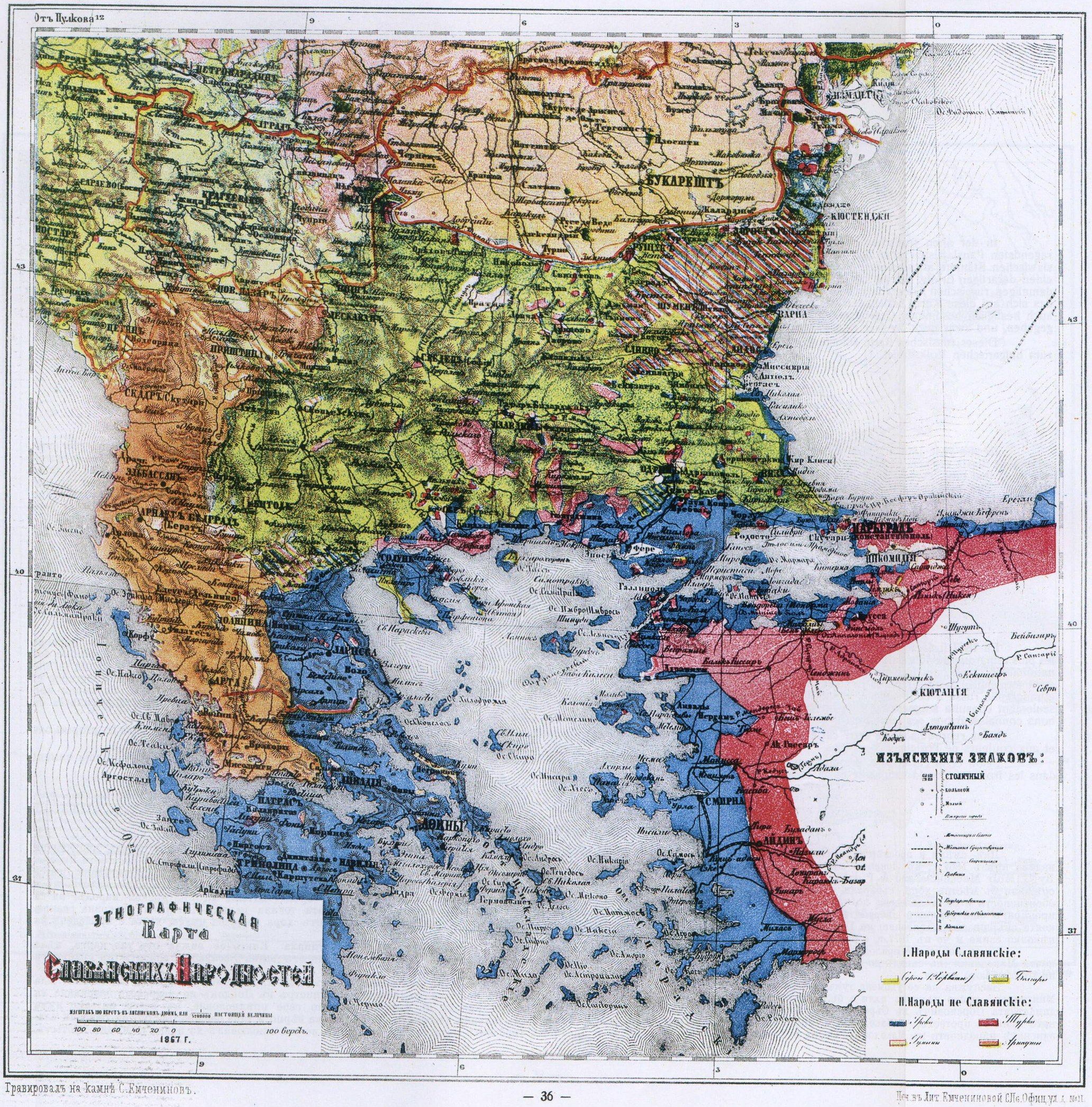
21. — The Russian Ethnological Map (1867).
In the year 1867 a „Slavic Exhibition” had been arranged at the instigation of the Russian Slavenofiles in the ancient Russian capital, Moscow, at which the most prominent Slavic workers of that time participated. For this celebrated exhibition, single of its kind up to this time, an ethnological map of all the Slavic races had been prepared which, at that time, made a great impression and which was approved by all delegates present. The map had such a success in its time, that up to 1877 it appeared in three editions. This map, become historical because of its importance, was drawn by M. F. Mirkowitsch, the Russian geographer and ethnographer, and it received the title „Ethnological Map of the Slavic Peoples”. — From a printed leaf relating to this map it appears that its author not only carefully consulted the ethnological literature of the Balkan-Peninsula, but that he also collected information concerning certain districts of the Balkan-Countries from the best authorities on these territories. We reproduce here in fac-simile, that part of this map which relates to the peninsula according to our method used thus far: dimensions and colours being the same as those of the original.
According to this Russian map nearly all Macedonia, the region of Nisch, even the townlet Kniajewatz (Grgussowatz) included, and the Dobrudja belonged to the dominion of the Bulgarian people.
35
![]()
( 21. — The Russian Ethnological Map (1867) )
36
![]()
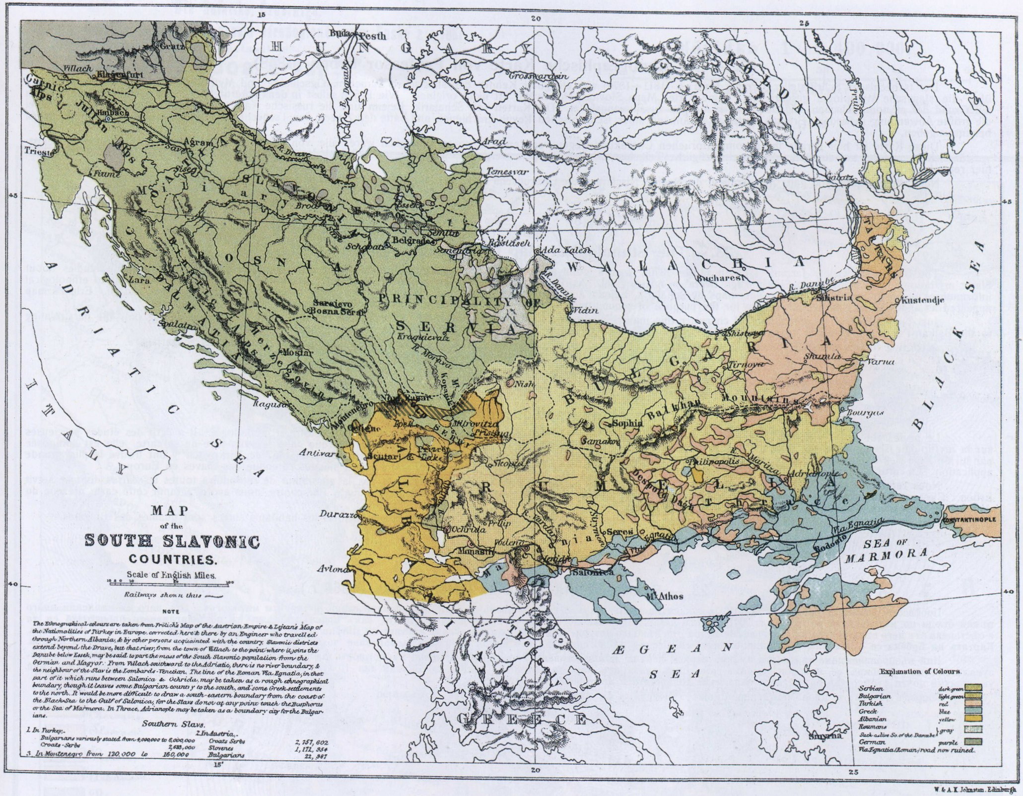
22. — The ethnological map by Mackensie and Irby (1867).
[[ Two courageous and enlightened British ladies, Mackensie and Irby, travelled through a large part of the Balkan peninsula in the years 1862 and 1863. They published their studies in 1867 in London in the book „The Turks, the Greeks and the Slavons. Travels in the Slavonic Provinces of Turkey-in-Europe. By G. Muir Mackenzie and A. P. Irby, London, 1867. With Maps etc.” The authors approached their subject very seriously. Everywhere they went they met the local people and collected information from them. The information was later checked with the consuls and missionaries. Their conscientiousness and objectivity was so high that when in Constantinople, they met with representatives of both the Greek Patriarchate and the Bulgarian people in order to verify once more the collected by them data. Simultaneously, they also investigated the ongoing at that time Greko-Bulgarian church dispute which ended with the creation of the Bulgarian Exarchate in 1870. How much their book was appreciated by the people versed in these matters is seen by the fact that it was translated into several languages and that a second edition appeared in 1877, with a foreword by the great Gladstone.
The book is supplemented with an ethnographical map which we reproduce in facsimile in the size of the original. As it can be seen from this map almost the whole of Macedonia (to the west reaching the river Cherni Drim and to the south-west – the mountain Gramos), the whole district of Nish, Dobrudzha and a part of southern Bessarabia are included in the boundaries of the Bulgarian people.
It is worth mentioning the interesting detail that this book was translated into Serbian by the well-known Serbian statesman and academician Cheda Mijatovich who also served several times as Serbian minister and who was for several years the Serbian ambassador in London until the brutal murder of the dynasty of Obretenovich in Serbia. Mr. Mijatovich presented this book to the Serbian people with one foreword, full with admiration, in which not only there is not a single word of objection that Macedonia and the district of Nish are shown as Bulgarian lands but he even praises Mackensie and Irby for their objective depiction of the Slavic peoples in Macedonia, Bosnia and Hertzegovina. And the Serbian readers of this book did not object either. ]]
37
![]()
( 22. — The ethnological map by Mackensie and Irby (1867) )
38
![]()
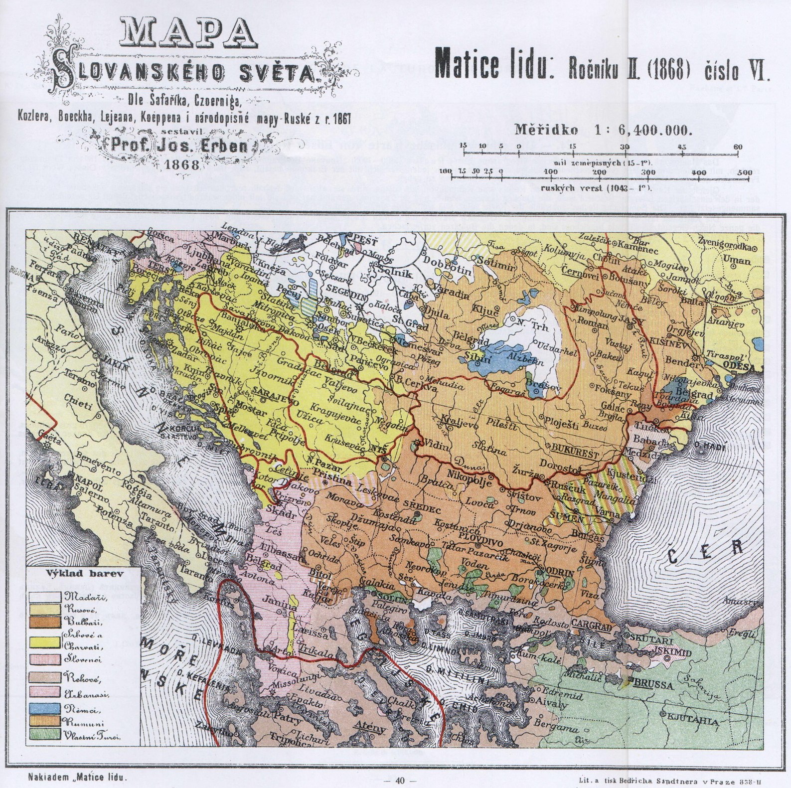
23. — The Ethnological Map by Professor Erben (1868).
The Bohemian writer, Jaromir Erben (1811—1870), was a good authority on Slavic language, history and mythology. He has written valuable studies about Slavic mythology. His map „Мара Slovanskègo Svèta” is not original. As Erben himself remarks in the under-title it has been drawn by him according to ethnological informations given by several authors. The maps by Schafarik, Lejean and the Russian map by Mirkowitsch (1867) have been most frequently made use of. Erben's map appeared as appendix to a bohemian review for the purpose of acquainting the Bohemians with the expansion of the Slavs in Europe.
Just on account of its compilatorical character this map is publisched here, as it is impossible to reprint all maps used by Erben. Of course only the part relating to the Balkan-Peninsula, enlarged nearly to double the size, has been reproduced here, accuracy and colours beeing as in the original.
According to this map, all Macedonia, the region of Nisch, and the Dobrudja are territories whose Slavic inhabitants are denoted as Bulgarians.
39
![]()
( 23. — The Ethnological Map by Professor Erben (1868) )
40
![]()
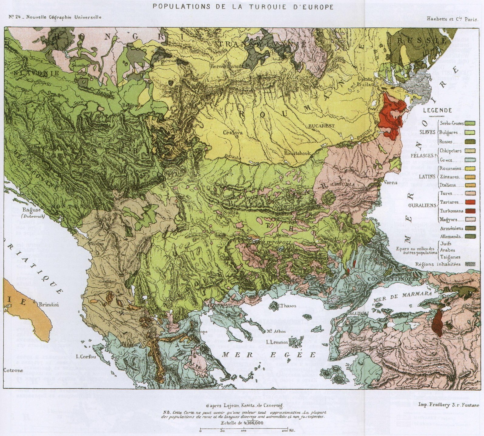
24. — The Ethnological Map by Elisée Reclus (1876).
The principal work of the renowned French geographer Elisée Reclus (1830—1905): „Nouvelle Géographie Universelle” which appeared in Paris from 1875 till 1894 in 18 large volumes, richly furnished with maps and pictures, has become a text-book for everybody interested in geographical matters. In France this work has been the first attempt to put geography on a scientific footing.
Like Erben's map, that by Reclus is also a compilation and as such reproduced here because an universally known geographer and well versed in the respective literatures has selected and compiled the sources (Lejean, Kanitz and de Czoernik) with truly scientific impartiality. The footnote by Reclus at the bottom of the map shows how far his impartialily went.
This fac-simile map is nearly the size of the original. Though the large towns, only, have been denoted, it is not difficult to find out that nearly all Macedonia and the whole Nisch-District are shown as territories in which the Bulgarians predominate.
41
![]()
( 24. — The Ethnological Map by Elisée Reclus (1876) )
42
![]()
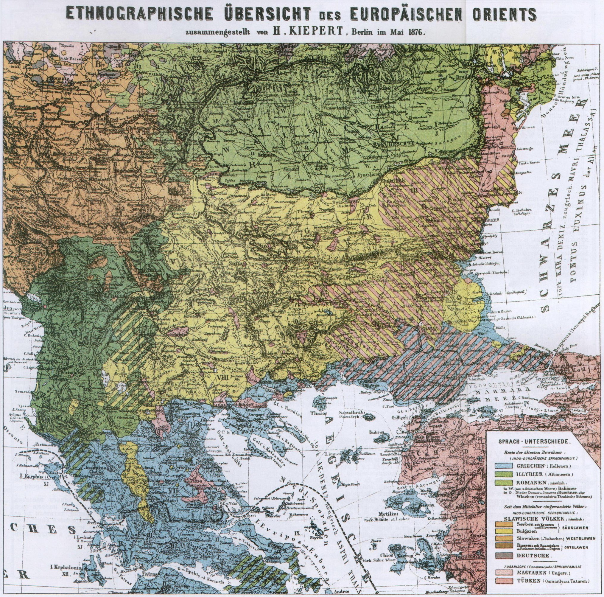
25. — The Ethnological Map by Kiepert (1876).
The fame attached to the name of the renowned German geographer and designer of maps, Heinrich Kiepert (1818—1899), dates from the appearance of his distinguished „Atlas von Hellas” (1846); he afterwards published the excellent maps of Asia Minor and Palestine which he had worked out on the spot; these were followed by the wellknown „Bibel-Atlas”, of which three editions were issued in the course of eight years. The numerous maps drawn by Kiepert are all distinguished by scientific value and by previously unknown accuracy. For his rare merits as a map-designer he received the „Grand Prix” at the Paris International Exhibition of 1867.
Kiepert undertook the exploration of the Ottoman-Empire first in Asia Minor and then in Europe. During these scientific explorations he necessarily visited also the countries inhabited by the Bulgarians where he questioned the local inhabitants, and also many such living in Constantinople, about the expansion of their race, in the meantime diligently studying the ethnological literature of the Balkan-Peninsula. The result of these researches and explorations is the map reproduced here in facsimile, but somewhat smaller for want of space. Although it indicates more Turkish and Albanese dwelling-places as had in reality existed there, it corrects many mistakes of former ethnological maps. It will be seen at a glance that Kiepert too looks upon all Macedonia (in the west with Albanian, in the south with Greek patches), and the whole district of Nisch as districts chiefly inhabited by Bulgarians.
This map by Kiepert had the happy lot to gain a certain historical importance: it served to the European Conference, held 1876—1877 at Constantinople, as a foundation for drawing the frontiers of both Bulgarian provinces. At the Berlin Congress of 1878 the frontiers of the Balkan-Peninsula were also fixed according to this map. It is also well known, what high value Bismarck has attributed to it.
43
![]()
( 25. — The Ethnological Map by Kiepert (1876) )
44
![]()
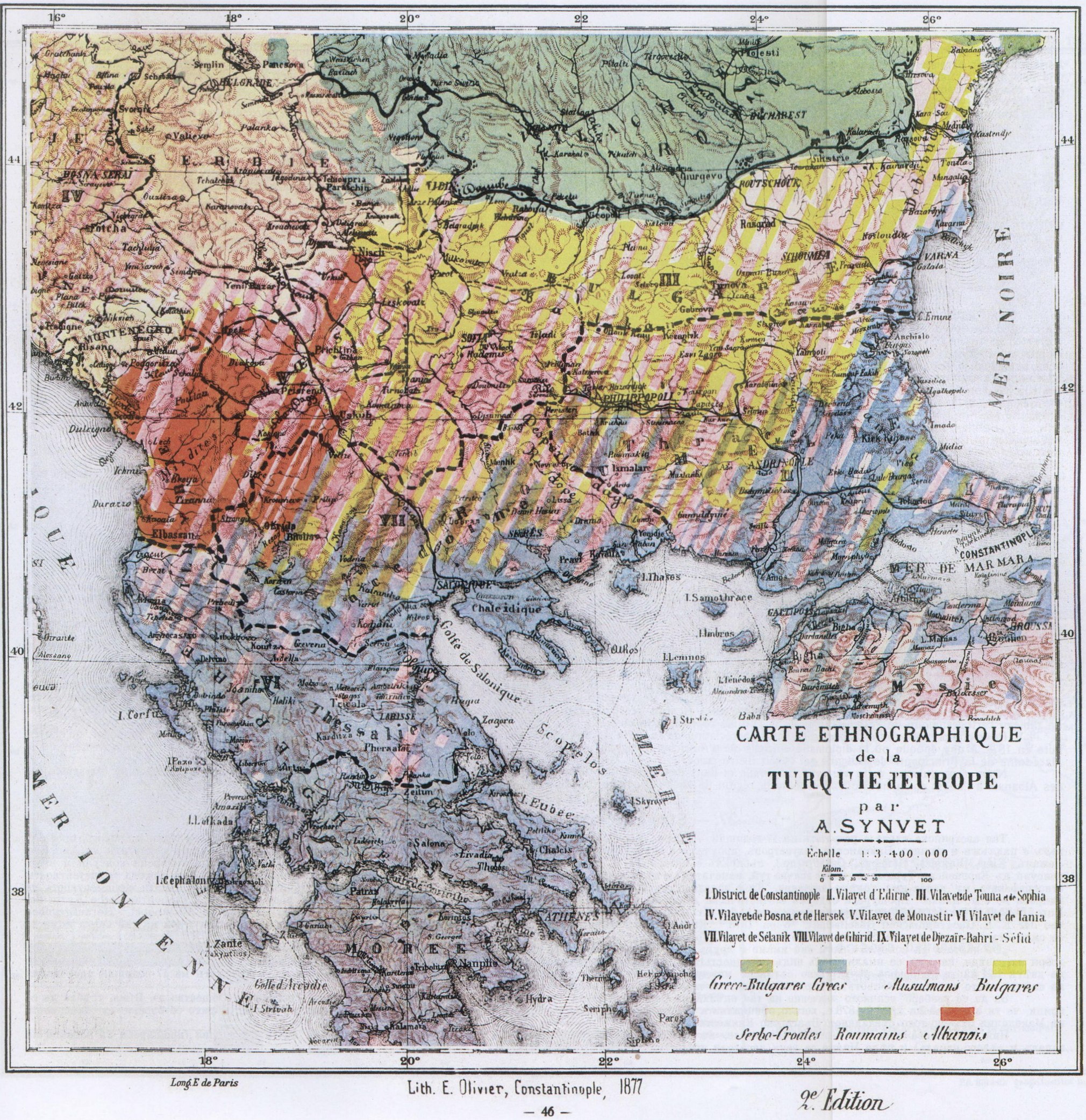
26. — The Ethnological Map by Synvet (1877).
This map is a Greek one. It is drawn by the Frenchman A. Synvet, Professor of Geography at the Ottoman-Lyceum in Constantinople; it is, however, put together according to information given by the Greek Patriarchate. And the Greeks have always considered it as a map of their own.
This map (fac-similated on a smaller scale) has been reproduced here upon three considerations: 1) to prove once more our total impartiality towards the other pretendents for Macedonia; 2) to show that the Greeks — Servia's allies of to day — did not recognise in 1877 the existence of Servians in Macedonia; and 3) to make it clearly prominent that the Greeks themselves look upon the christian majority of Macedonia as Greeks speaking bulgarian. Synvet calls them on his map Grecco-Bulgarians, and the greek newspapers have always spoken of them as Greeks of Bulgarian tongue („Vulgarophoni Hellini”). The explanation given by the Greeks for their theory of Bulgarian-speaking Greeks, is very odd: They claim that Macedonia had always been inhabited by Greeks but that hords of Bulgarian barbarians, after invading the country, have enforced their language upon them. Is it possible, we ask, that an uncultivated people can impose its barbarian language upon a cultured nation speaking the language of Socrates and Demosthenes? We leave it to our foreign intelligent readers to express their opinion as to how far this Greek theory has any foundation. We only call attention to the historical fact that in the course of five centuries the Turks have not succeeded to enforce their language on those nations that have been subjugated by them in Europe, not even on those Christians that have gone over to the Mohamedan faith; and all the world knows that the Mohamedan Greeks of Epirus speak Greek, the Mohamedan Servians of Bosnia and Herzegovina speak Servian, and that the Mohamedan Bulgarians of Macedonia and of the Rhodope speak the Bulgarian language.
45
![]()
( 26. — The Ethnological Map by Synvet (1877) )
46
![]()
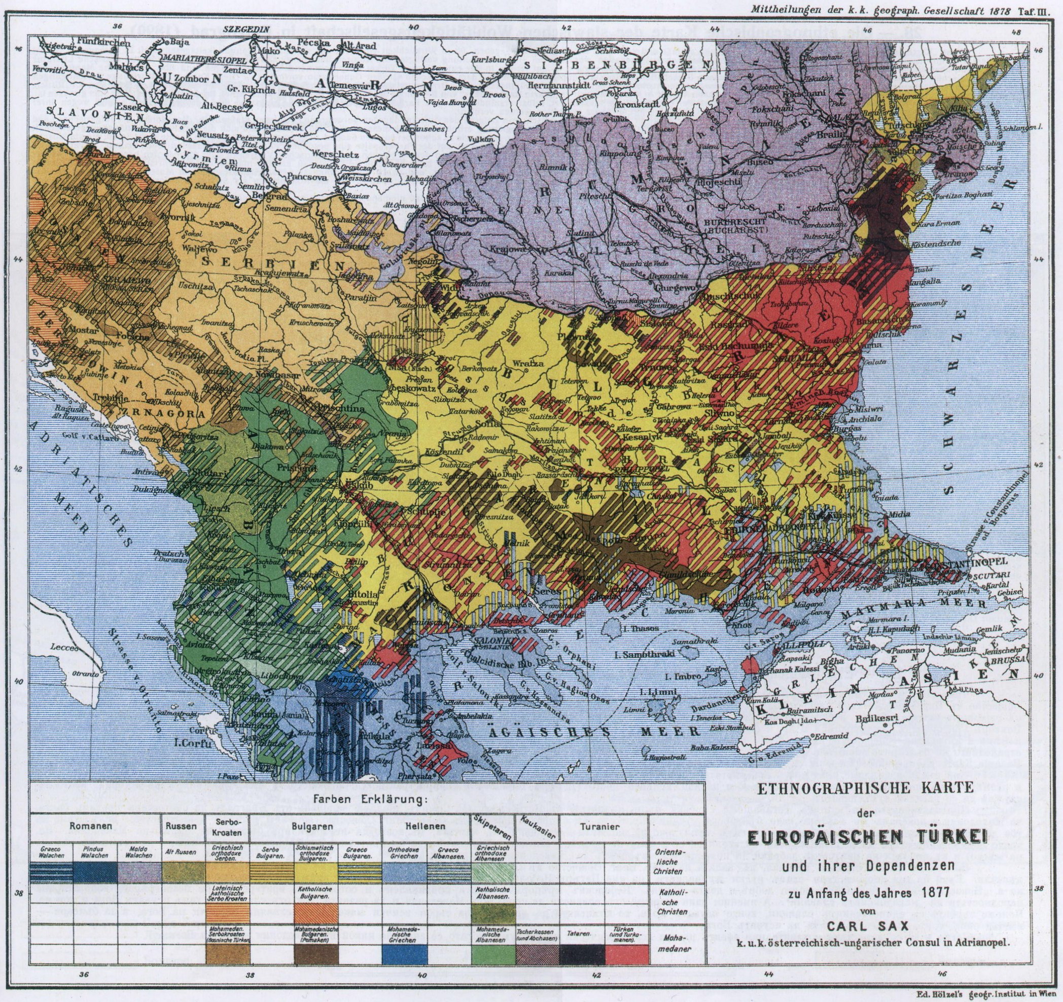
27. — The Ethnological Map by Sax (1877).
This Austrian map is the result of a seventeen-years labour. Karl Sax has been a long time Austro-Hungarian Consul at Sarajewo, at Rustschuk and at Adrianople. He crossed European Turkey from end to end (he knew the works and maps by Boue, Lejean, von Hahn, Kanitz, Kiepert, Syvet, and others), gathering material which he corrected according to the informations received from almost all Austro-Hungarian Consuls and Vice-Consuls of European Turkey; and after all this he published a long series of important researches about the populations of these countries. On account Sax's authoritative knowledge of the subject his map is of great importance. It has been published in 1878 by the Imperial and Royal Geographical Society of Vienna, whose competency on this question is well known. The pamphlet contains statistical information about the different peoples of European Turkey under the title „Ethnographische Karte der europäischen Türkei und ihrer Dependenzen zur Zeit des Beginns des Krieges von 1877 von Karl Sax, K. und K. Österreich-ungarischer Konsul in Adrianopel”. („Ethnological Map of European Turkey and her Dependencies at the Time of the Beginning of the War of 1877, by Karl Sax, I. and R. Austro-Hungarian Consul at Adrianople. Publisched by the Imperial and Royal Geographical Society, Vienna 1878.”) From the following remark contained in the pamphlet one can judge how the Austrian geographical Society appreciated the scientific value of this map:
„Besides the map by Consul Sax. we also posses the sketch of an ethnological map designed by Baron Karl von Kraus according to best sources, in which the nationalities of the inhabitants of Turkey and their confessions are taken into consideration, as Sax has done it too on his map. A close comparison of both maps shows their nearly complete conformity and convinces us that the map by Consul Sax, the result of seventen-years labour on the spot, offers a map-designed-view of the ethnology of Turkey which is nearest to the facts.”
In order to understand the full importance of this estimate of Sax's map by the Imperial and Royal Geographical Society one has to keep in mind that the map was designed 1878 and that at that time the official diplomacy of Austria, being afraid of Russia's expansive policy, fought openly for a separation of Macedonia from the newly created Principality of Bulgaria.
This fac-simile map is reproduced here with imperceptible alterations in its dimensions. According to it, nearly all Macedonia (with Albanian patches west and northwest), and the whole district of Nisch are chiefly inhabited by Bulgarians.
47
![]()
( 27. — The Ethnological Map by Sax (1877) )
48
![]()
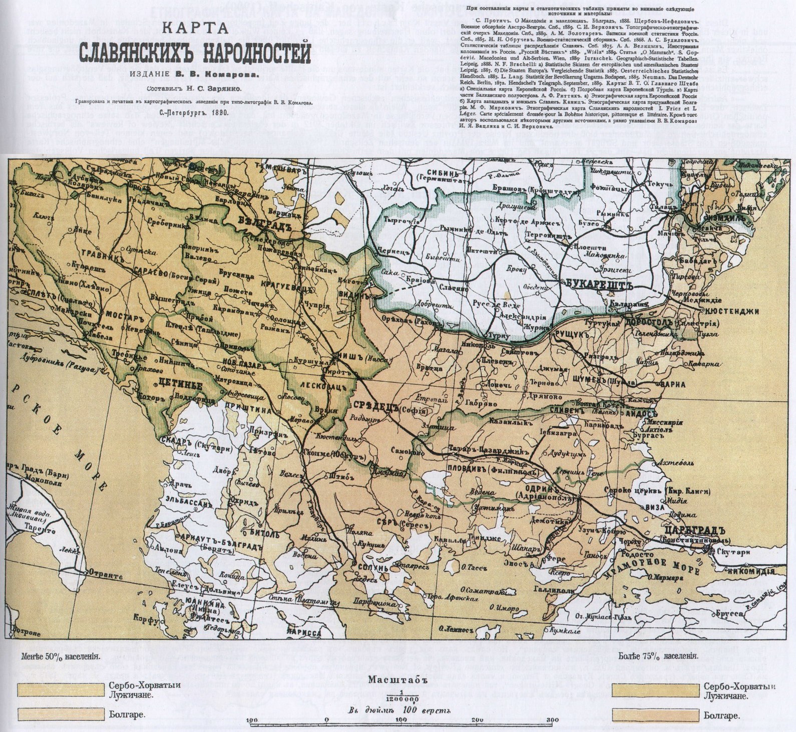
28. — The Ethnological Map by the Slavic beneficent Society of Petrograd (1890).
This Map of the „Slavic Peoples” edited by N. C. Zarjanko and published by V. V. Komaroff, is in reali y the work of the Slavic beneficent Society of Petrograd. It was designed under the control of the professors of slavistic who were members of the society. The authors had at their disposal an uncommonly rich literature on the matter, foreign as well as Russian, consisting in the researches made in European Turkey by well-known Russian explorers like Viktor Grigorowitsch, Hilferding and others; they also disposed of the rich material found in the Russian Foreign Office, in the Russian Embassies at Constantinople and at Vienna, and at the Russian General-Staff. This map contains important corrections of that published on page 35—36 Russian map of 1867, chiefly relating to the expansion of the Bulgarians in South-Thracia, Deli-Orman, and in the Dobrudja; it approches the Russian map by A. F. Rittich „Map of the West- and Southern Slavs. Petrograd. Published by the cartographic Institute A. Ilin”, as well as the „Map of Macedonia” by B. Teplow, who for a long time was an official of the Russian Embassy at Constantinople.
The part relating to the Balkan-Peninsula is rendered here in fac-simile, according to the first edition, colour and size being as in the original. It is published on account of its authenticity, accuracy, and impartiality, and because it has a history of its own which deserves to be shortly told: —
On the appearance of the map, G. Simitsch, at that time Servian Ambassador at Petroarad, received the order from Belgrad to protest against the designation of Macedonia as a Bulgarian country on the map. The protest was made before the Slavic beneficent Society and belore the Russian Government. In consequence of this double protest, the Slavic beneficent Society was forced to publish a second edition on which the Bulgarian colouring of Macedonia had been removed. But — as usual on such occasions — the editor did not think of changing the statistical index of the Bulgarians in Macedonia (which for want of space is not reproduced heie), and he forgot to indicate with a special colour the „Macedonic-Slavs”.
In the saloons of the Slavic beneficent Society this odd story provoked long disputes about Macedonia between the Servian and the Bulgarian representatives. A Russian journalist by the name of Peter Nebolssin, who had lived for a long time in Bulgaria and Servia as correspondent of the „Nowoje Wremia” and to whom both the peoples were well-known, put an end to this controversy: Nebolssin recommended a most original and very ingenious critérium to settle once for all the nationality of the „Macedonic-Slavs”, viz: a commission of Slavs were to travel about in Macedonia to find out who of the Slavs are blasphemers and who are not. Since Servians are the only Slavs that utter imprecations against God, the commission should have to declare as Servians all those Macedonic-Slavs that blaspheme, and as Bulgarians all those that look upon blasphemy as a sin.
Everyone can imagine the knock-out effect of this psychological critérium when he bears in mind that in Macedonia nobody is blaspheming God.
49
![]()
( 28. — The Ethnological Map by the Slavic beneficent Society of Petrograd (1890) )
50
![]()
29. — The Ethnological Map by Kantschoff (1900).
This map of Macedonia is a Bulgarian one. Its author is Vassil Kantschoff who for a long time was Inspector of the Bulgarian Schools in Macedonia and crossed, in this capacity, the country in all directions. It can be said without exaggeration that there is not a single spot in Macedonia that he has not visited and investigated. He was particularly suited for such studies because he possessed thoroughly the whole ethnological literature of the Balkan Peninsula, and because he was an incredibly objectiv man, even in national and political questions. Moreover, all Bulgarian teachers in Macedonia were for this purpose at Kantschoffs disposal, and they knew their districts as they did their own pockets.
It is to be deplored that want of space enforced the diminution of this facsimile map to at least one half, so that it will be difficult to decipher it without a magnifying glass. But the readers are already so familiar with the ethnological map of the peninsula that they will be able to read this ethnological map of Macedonia, even if it is considerably smaller.
We regret sincerely that we cannot adjoin to this map that one composed by the contemporary Servian geologist professor Zwiitch who is the ideologist of the chauvinisme panserbism and also the inventor of the „Macedonian-Slavs”. But as this Servian scientist has uttered in the space of only 5 months, out of purely political reasons, two different opinions about the ethnology of Macedonia, it may be assumed that his ethnological map has no scientific value whatever. It is known that in the English magazine „Review of Reviews” of October 1912 Professor Zwiitch admitted as Servian ethnological sphere in Macedonia only the northern burroughs of the Uescub district (the towns Uescub, Kumanovo and Tetowo) with a small part of Northwest-Macedonia (the towns Debr and Struga), whereas in March 1913 he publisched an ethnological map in the German journal „Pelermanns geographische Mitteilungen” in which nearly one half of Macedonia had the blue Servian colour; the rest of the Bulgarians (excepting the inhabitants of the east-frontier) he proclaimed as „Macedonian Slavs”.
51
![]()
( 29. — The Ethnological Map by Kantschoff (1900) )
