10. Bulgaria at the time of Samuel
11. The Patriarchate of Ochrida
12. Bulgaria at the time of Assen I and Kalojan
15. The ethnological map by Schafarik (1842)
17. The ethnological map by Davidovitsch (1848)
10. — Bulgaria at the time of Samuel.
After the Byzantinic Emperor John Zimiskes had conquered the eastern part of the Bulgarian Empire in the year 972, the Bulgarians not only maintained their independence in the western part, but they even succeeded to deliver the eastern part they had lost (with the exception of the Bulgarian part of Thracia), and to seize Servia, nearly the whole of Albania, and a part of Thessaly. This happened under the warlike Czar Samuel (980—1014), who, during the whole of his reign fought against the Byzantinic Emperor Basilius II without interruption. The Bulgarian Empire in its greatest expansion (996) under Samuel, when he stood in the height of power, has been delineated on the map. But under the weak successors of Samuel the Bulgarians could not hold out the many-years wars against the mighty and energetical Emperor Basilius II, who at length succeeded in the year 1018 to subject the Bulgarians under his rule. By no means, however, this subjection bore the stamp of servitude, for it took place „by virtue of treaty”. This matter of fact Basilius II himself renders prominent in his edict, according to which the Bulgarians maintained their right of autonomous government, their ecclesiastical independence, and the name of their country. Want of space, unfortunately, does not permit the reproduction of the „Military and Administrative Regulation for Bulgaria” edicted by Basilius II at the time of its subjugation. According to it Bulgaria in spite of the division into 4 provinces, maintained its unity which found expression in the person of the „Stratigos of the Bulgarian Province”; he bore the title „Duke” or „Satrap of all Bulgaria”, was looked upon as Vice-Emperor and Skopie (Ueskub) was his residence. This unity of the Bulgarian territory had also been ensured through the acknowledgment of the Bulgarian National Church in such boundaries as it had during the time of the Bulgarian Czar Peter, — by means of the treaty of 927.
13
![]()
( 10. — Bulgaria at the time of Samuel )

14
![]()
11. — The Patriarchate of Ochrida.
As mentioned, Emperor Basiiius II had acknowledged the full independence of the Bulgarian National Church inside its old boundaries by special edicts. The representativ of this church bore furthermore the adjective „Autocephal” and the title „Archbishop of all Bulgaria”, and had his seat at Ochrida. On this account the Archbishopric of Ochrida is recognised as a continuation of the former Patriarchate of Drister and of Preslaw (at the time of the Czars Simeon and Peter) which had been abolished in so arbitrary a manner by the Byzantinic Emperor John Zimiskes. After the subjection, Basilius II recognised the rights of the Bulgarian National Church in three edicts, directed to the first Archbishop of Ochrida, the Bulgarian monk Iwan; this one (who was born at Debr) was elected by the bishops and sanctioned by Basilius in the year 1020. According to the text of these edicts the following eparchates belonged to the Patriarchate of Ochrida:
1. Ochrida, 2. Kostur, 3. Glawinitza, 4. Moglen, 5. Pelagoni (Bitolia, Monastir), 6. Strumitza, 7. Morowisd (Bregalnitza), 8. Welbuschd (Küstendil), 9. Triaditza (Sofia), 10. Nisch, 11. Branitschewo, 12. Belgrad, 13. Trap (Srem), 14. Skopie (Ueskub), 15. Prisren, 16. Liplian, 17. Raschka, 18. Orey, 19. Bdin (Widin), 20. Kosil, 21. Tschernitza, 22. Drinopol (Argyrokastro), 23. Botruit, 24. Chimara, 25. Janina, 26. Staj, 27. Petrska, 28. Servia (Selfidsche), 29. Wereja (Karaferija), and 30. Dristar (under this, all eparchies of North-Bulgaria were known).
This numbering finds itself on the map too. The note of interrogation behind the several numbers means that the position of the eparchate concerned is not as yet, fixed accurately.
15
![]()
( 11. — The Patriarchate of Ochrida )

16
![]()
12. — Bulgaria at the time of Assen I and Kalojan.
The first heavy armed blow against the rulership of Byzanz was the revolution raised 1186 by the brothers Assen and Peter in north Bulgaria. After a two-years struggle, powerfully led against the Byzantinic yoke, they established 1187 the political and ecclesiastical independence of Bulgaria, and Assen's election to the throne laid the foundation of the second Bulgarian Empire, with Tirnowo as capital. During his nine-years reign (1187—1196), Assen I who also took up the fight against Byzanz, this time with the aim of delivering and uniting all Bulgarian territories, succeeded to deliver nearly the whole north Bulgaria, and the district of Sofia as well as all provinces south of the Balkan Mountains, and the Sredna Gora (the northern Thracia). At the end of his reign he directed the liberation - movement along the Struma valley, to Macedonia, but, falling victim to assassination, he could not confirm his power there.
His work, however, was taken up again by his brother and successor to the throne, Kalojan (1197—1207). This czar understood to benefit of the tragic events, happening to the Byzantinic Empire — the conquest of Constantinople by the crusaders, the fourth crusade, and the establishment of the Latin-Empire on the Balkan-Peninsula. The crusaders being still engaged in the siege of Constantinople, Kalojan in a short space of time, could annex nearly all the Bulgarian Balkan districts: the Morawaland in the West (the Branitschewo district and Belgrad), and Macedonia down to the Bistritza river in the south-west. The uninterrupted wars that soon after began against the Latins and the Greeks, enabled him also to occupy all south-Bulgarian territories, including the city of Ser (Serres). Kalojan, however, could not follow up his plan to reject the Latins from the Balkan-Peninsula and conquer Constantinople. Like his brother, he was assassinated 1207 during the siege of Salonica.
This map shows Bulgaria, delivered by czar Assen I, and enlarged by his brother Kalojan.
17
![]()
( 12. — Bulgaria at the time of Assen I and Kalojan )

18
![]()
13. — Bulgaria at the time of Assen II.
The Bulgarian people gained its full political and national unity under the reign of Iwan Assen II (1216—1240), son of Assen I. Thanks to his foresight and political fitness, this czar prepared in a very apt manner the downfall of his rival, Theodore Angel Komnin, the despot of Epirus, who, at the time of the weak czar Boril, had subjected the Bulgarian territories in the south-west, and who even brought about the conquest of Salonica. Theodore proclaimed himself Emperor of Salonica 1223, and made preparations to rescue Constantinople from the rulership of the Latins in order to ascend the Byzantinic throne himself. But as Theodore Komnin first had to get rid of his rival, the Bulgarian czar, he, above all, resolved to make an end of Iwan Assen, so he maliciously declared war against him. This war ended 1230 with the celebrated battle of Klokotnitza (the present village Semidje, northeast of Haskowo) where Theodore and his followers were taken prisoners by the Bulgarian czar.
After this event all his territories, including Albania, were incorporated in the Bulgarian State. Thessaly and Salonica, and their districts, formed a „Despotia” under the protectorate of the Bulgarian czar; the administration was entrusted to Manuel, Theodore Komnin's brother, who was the son-in-law of Iwan Assen.
This map shows the enlargement of the Bulgarian State after the victory of Klokotnitza.
19
![]()
( 13. — Bulgaria at the time of Assen II. )

20
![]()
14. —Bulgaria after 1355.
After Iwan Assen's death the rapid downbreak of the Bulgarian State set in.
Torn by interior disputes and riots that often assumed the character of civil-war, and permanently attacked by foreign ennemies (Niceans, Tatars, and the Byzantinians after the restoration of the Byzantinic Empire), Bulgaria was not able to counteract the rapid growth of Servia, which became conspicuous at the end of the XIII. century. The Servian kings of that time succeeded to enlarge their state by winning Bulgarian territories in the Pomorava district and in Macedonia, so that Servia gained its greatest expansion at the time of Stefan Duschan (1331—1355). But after Duchan's death his extensive empire broke up into a number of smaller states, each of which hastened to proclaim its own independence. Thus two small independent states formed themselves out of the Bulgarian territory in Macedonia: the Kingdom of Prilep whose ruler was Volkaschin and, after his death, his son, Krai Marco, the latter being the wonderfully praised hero of the nationalpoetry of Bulgaria, and the Principality of Welbuschd which was reigned over by Iwan Dragasch and his mother, afterwards by his brother Constantine, a son-in-law of the Bulgarian czar Iwan Alexander.
Internal political reasons soon after forced the czar Iwan Alexander (1331—1371), in the year 1355, to discharge himself of the city of Bdin (Widin) and the whole surroundings, and to give them to his eldest son, Iwan Stratzimir, who ruled over this land as independent czar.
In a similar manner he also cut off the province of the east-coast (Dobrudja, Silistra, and Warna) which became half-independent principality (at first) under the administration of Balik, later under Dobrotitsch; this latter becoming independent ruler after Iwan Alexander's death.
Thus fell to pieces the old, great Empire of Iwan Assen II in the year 1355, hereafter forming several small states: the Kingdoms Tirnowo and Widin, nearly constantly in war with each other, the Kingdom Prilep, the Principality Welbuschd and the coast-district (Primorie). The Morawa district, however, remained in foreign hands. The Bulgarian Empire, cut down in such a manner, was not able to withstand the terrible pressure of the Turks, the new conquerors of the Balkan-Peninsula. It was easy for the latter to subject the small states one after the other, and by the end of the XIV. century they established their supremacy on the Balkan-Peninsula more and more.
This map shows the decay of the second Bulgarian Empire before the subjugation under the rule of the Turks.
21
![]()
( 14. —Bulgaria after 1355 )

22
![]()
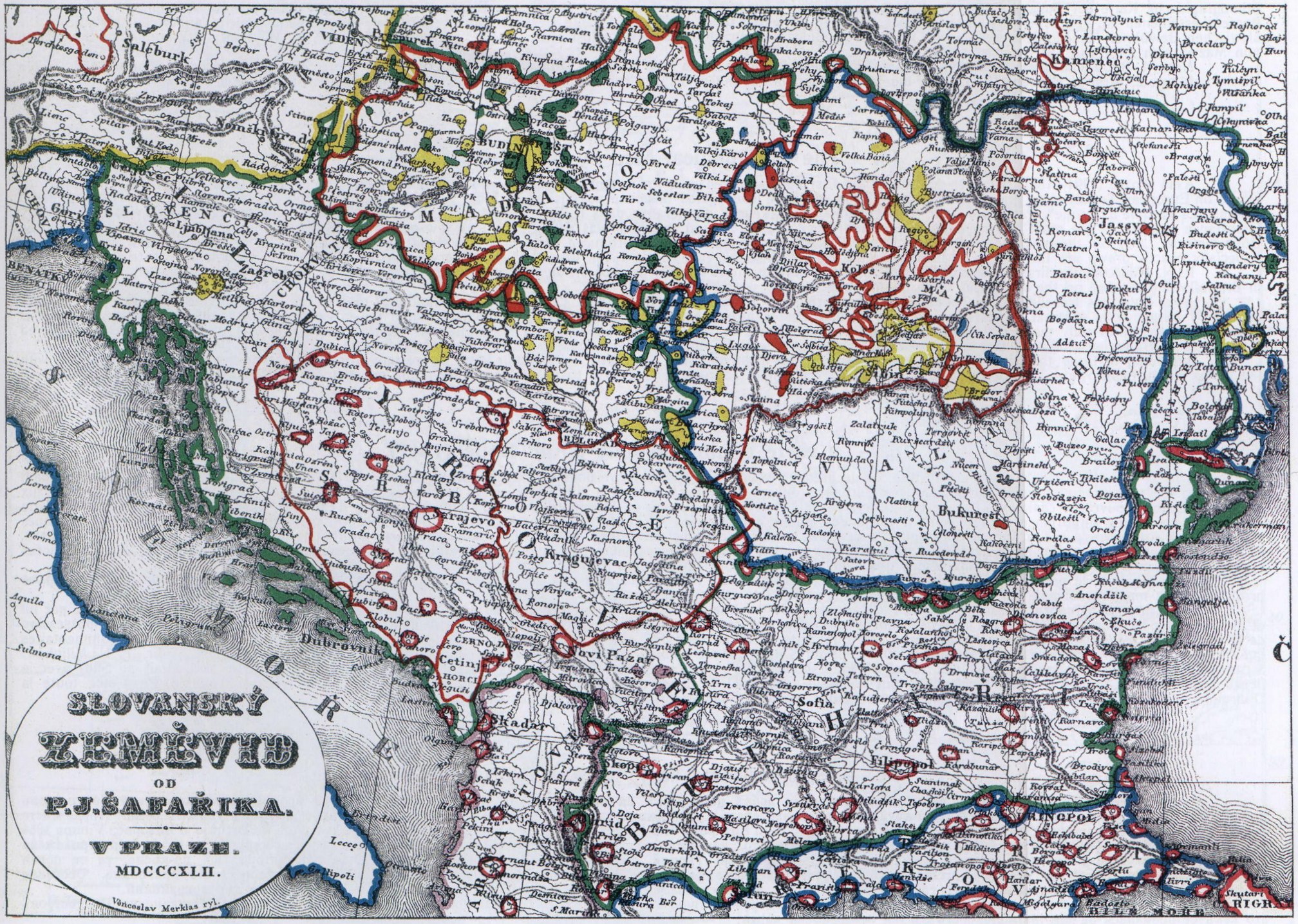
15. — Schafarik's Ethnological Map (1842).
Paul Josef Schafarik, (1795—1861) of Bohemian nationality, is the first Slavic scientist who designed a map of the ethnographical frontiers of the Slavic nations. The map reproduced here in fac-simile has been taken from his ethnographical map „Slovansky Zemevid” published at Prague 1842. We print here only that part concerning the Balkan-Peninsula — exactly on the same scale as the original.
Schafarik has not travelled in the Balkan-Peninsula, but he was always in connection with the inhabitants of the Balkan-countries, he knew well the history, the language, the literature, and the antiquities of the Slavic peoples, and — which here is of the utmost importance — he knew thoroughly the Servian language and the boundaries of the Servian race, for he was professor at the Servian Lyceum of Nowi-Sad (Hungary) for a period of 14 years.
He left the Lyceum 1835 and settled down at Prague. There he devoted himself to the study of the Slavs and the slavic antiquities, which studies he had already commenced, according to his biographer, at the Lyceum. (La Grande Encyclopédie, vol. 29.)
Schafarik's map does not go into details; his merit, however, consists in his being the first who very exactly delimitated the Bulgarians from their neigbours — the Servians, Rumanians, Greeks, and Albanians. According to Schafarik nearly the whole of Macedonia, the region of Nisch, the whole of Dobrudja, and even a part of to-day's russian Bessarabia are territories inhabited by Bulgarians.
23
![]()
( 15. — Schafarik's Ethnological Map (1842) )
24
![]()
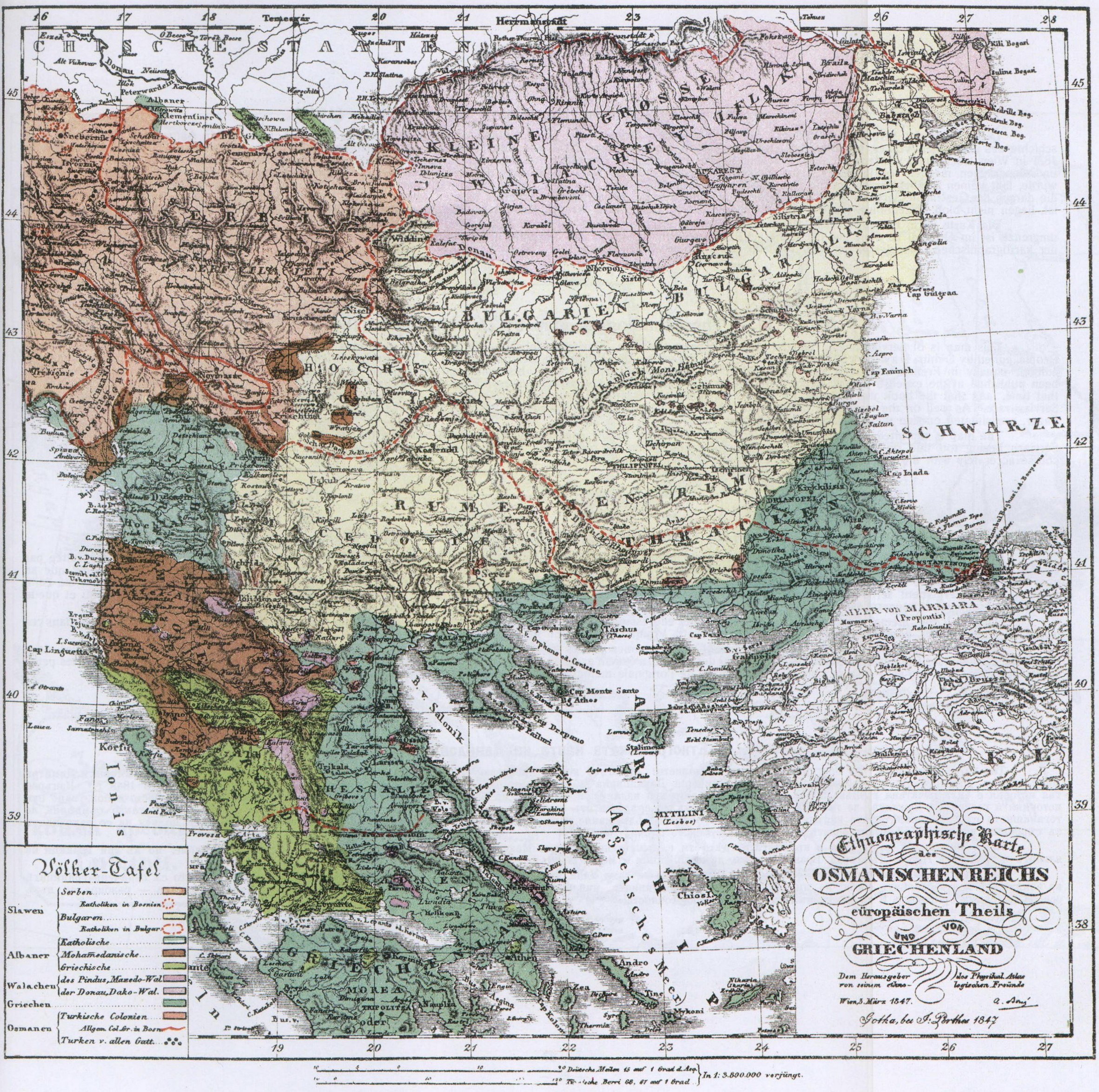
16. — The Ethnological Map by Ami Boué (1847).
Ami Boué (1794—1881) of French descent, is the first duly prepared man for scientific research who explored the Balkan Peninsula from 1836—1838. His numerous works on European Turkey show evidently the careful way in which he investigated the countries visited by him. Among these books the first place is due to his two principal works: „La Turquie d'Europe”, Paris 1840 (four thick volumes) and „Recueil d'Itinéraires dans la Turquie d'Europe”, Vienna 1854 (two volumes). His map is of extraordinary importance because of the most fundamental studies made every-where. At first this map was added only to a few copies of the works; these were originals, coloured by Boue himself. Later on, the map appeared in the „Physical Atlas” by Berghaus; it is reproduced here on a somewhat smaller scale but in fac-simile-colours of the original. Especially exactly drawn are the western boundaries of the Bulgarian people just because Ami Boue had made very extensive studies in these boundary-districts.
P. N. Miljukoff, the first Minister of Foreign Affairs in revolutionised Russia, one of the best contemporary authorities on Balkan-Peninsula matters, utters himself in the following manner on the scientifical worth of this map:
„Ami Boué has travelled in the Turkish Provinces during the Third Decade of the XIX. Century. The ethnological map of the Balkan-Peninsula drawn by him, and printed by Berghaus, is of great interest because it is the first that appeared before the national tendency-quarrels about the possession of Macedonia had begun. For this reason the map shows only that which the author had seen and heard on the spot, without whatever interpretations. The Slavic inhabitants of Macedonia are considered by A. Boué as Bulgarians, because they call themselves „Bugari”. (see P. N. Miljukoff: „Five Ethnographical Maps of Macedonia with Text. St. Petersburgh 1900”).
According to Boué the whole of Macedonia (excluding the most southern part) with Czerni-Drin-River as western frontier, the whole southern Morava-Basin with the towns Nisch, Lesskowetz, Wranja, Prokupie, Pirot a. s. o., the whole. Dobrudja, and even a part of Russian-Bessarabia are districts inhabited principally by Bulgarians.
25
![]()
( 16. — The Ethnological Map by Ami Boué (1847) )
26
![]()
17. — The Ethnological Map by Dawidowitsch (1848).
This map is of Servian origin. On the original it bears the title „Territories inhabited by Servians” and forms a supplement to the book: „History of the Servian People, edited by Dimitri Dawidowitsch, and translated into French by Alfred Vigneron, Belgrad 1848.” This history has originally appeared in Vienna in 1828, whereas the new edition, equally in French translation, was published at the cost of the Servian State; historians and geographers frequently make use of it. The fact that this work has been published at the expense of the Servian State and that it was translated in french leaves no doubt as to the full approval of its contents by the Servian Government of that time, and that the book was intended for use by foreigners in order that they should learn from it as well the history of Servia as the ethnological boundaries of the Servian race. As well on the map, as in the book to which it is added not only Macedonia, but also the towns Nisch, Lesskowetz, Wranja, Pirot, even Prischtina and Novi-Pazar, are situated outside the boundaries of the Servian race.
The map is reprinted in fac-simile. Some colouring, however, having appeared indispensable because of the small-dotted line that bounds the districts inhabited by Servians beeing too thin on the original and not prominent enough on the reprint, we had to make more prominent by red colour the line of the southeast-boundary, of course accurately with the original and with the exactness of scientific map-drawing.
27
![]()
( 17. — The Ethnological Map by Dawidowitsch (1848) )
28
![]()
18. — The Ethnological Map by Professor Dejardin (1853).
This map is also of Servian origin. It bears the title „Servia and the districts in which Servian language is spoken a.s.o. by Professor K. Dejardin. Belgrad, 1853.” Although its author bears a French name, he was one of the best-versed professors in the Servia of his time. Modestly the author states that his map had been put together according to „Dawidowitsch and other Servian authors.” As a matter of fact it represents the realm of the Servian language just as the scientists of that time, who had not been influenced by chauvinistical Pan-Servianism, did. For this reason this map is a valuable document against the Servian pretensions of to-day.
It is easy to see that on this map as well, neiiher Macedonia nor the towns Bela-Palanka, Pirot, Lesskowetz, and Wranja are included in the „districts in which Servian language is spoken.” There is no doubt that if this map, as well as that by Dawidowitsch, had been published before 1833, the Timok river-basin would not have been added to the „by Servians inhabited districts” and „in which the Servian language is spoken”, because Turkey left this basin to the Servian Principality only in 1833. From the history of Servia it becomes evident that the valleys of the rivers Timok and Nischawa as far up as Mount-Kunowitza never belonged to Servia — not even, at Duschan's time when Servia had reached the height of her power, nor even when the Servian Patriarchate of Ipek existed. These facts are substantiated by Professor St. Stanojewitsch on the maps of his work „History of the Servian People.” His history is the best Servian compendium on this subject and as such it is used in all Servian grammar-schools.
29
![]()
( 18. — The Ethnological Map by Professor Dejardin (1853) )

30
![]()
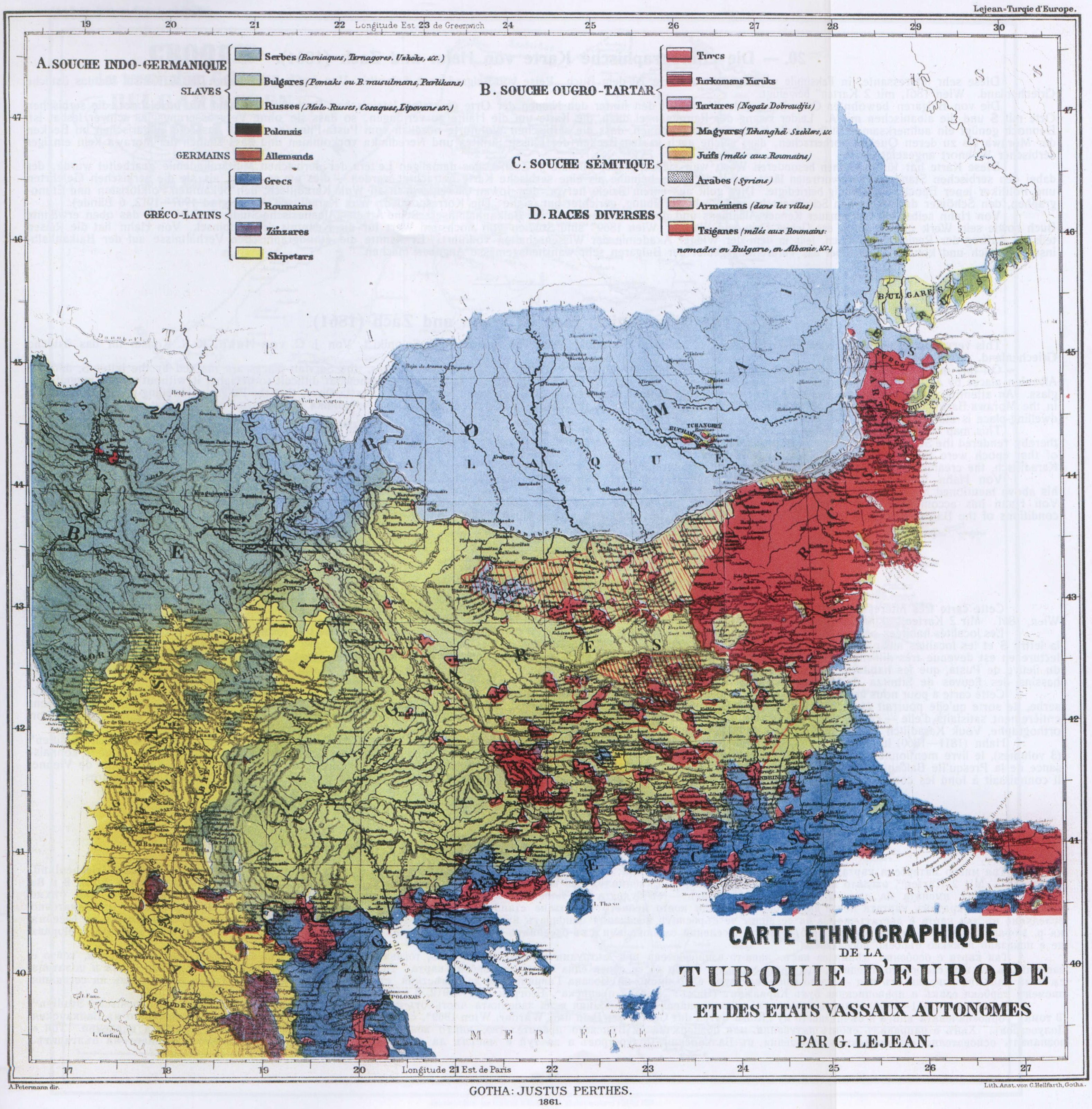
19. — The Ethnological Map by Lejean (1861).
Guillaume Lejean (1828—1871) was one of the most studious and pluckiest French explorers. Twice he travelled in European Turkey (1857—1858 and 1867—1869), the last time in the quality of French Vice-Consul. The purpose of his enterprise, undertaken by order of the French Government, was to prepare a map of European Turkey; Lejean's early death prevented the completion of this work; he succeeded, however, to publish very important geographical and ethnological essays, of which a respectable place is due to his work „Ethnographie de la Turquie d'Europe par G. Lejean. Gotha, Justus Perthes 1861”, publisched in German and French languages.
The map reproduced here has been taken from this work. It contains several mistakes, for instance: it shows too many Turks in East-Bulgaria and it mentions Servian settlements in the Ochrida-District, and Roumanian colonies in the Wratza-District that have never existed. On the other hand, Lejean frequently corrected certain mistakes made by his predecessors concerning the extent of the Bulgarian population in the districts of Nisch and in the Dobrudja.
According to Lejean nearly all Macedonia (with the exception of Salonica and a frontier-stretch in Southeast-Macedonia), the whole district of Nish, the coast-district of Dobrudja, and a part of Russian-Bessarabia are chiefly Bulgarian territories.
31
![]()
( 19. — The Ethnological Map by Lejean (1861) )